
|
|
Route |
|---|---|
|
|
42.47995°N / 13.55885°E |
|
|
Mountaineering |
|
|
Spring, Summer, Fall, Winter |
|
|
Most of a day |
|
|
F+ 40° on snow - II UIAA |
|
|
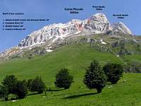
Overview: the winter normal route
 Click to enlarge
Abbate-Acitelli couloir is the normal route from north and it's the easiest route to climb (or descend) Corno Piccolo during winter season. The couloir is the less steep of the Corno Piccolo's north side and the approaching is quite short (2/3 hours from Prati di Tivo) even if could be dangerous for avalanches. It reaches the wide bowl under Corno Piccolo summit: from there, you can easily reach the west ridge, leading to the top.
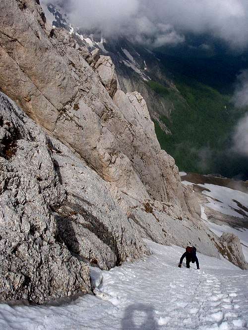
In summer, when the mountain is dry (without snow) the climb consists of a walk on steep scree-slopes with some passages up to II UIAA: it could be a fast route to descend from Corno Piccolo north side, after the climb of harder routes.
The normal route from north was climbed by Enrico Abbate and Giovanni Acitelli, during the first ascent of Corno Piccolo (18th of september 1887): they descended from normal route from south, so they did at the same time the first climb and the first traverse of the mountain.
The coluoir can be skied, but only by very good skiers! Ask for info to Sp member as.
Best season to climb: winter and spring, when Corno Piccolo's north side is covered in snow. Watch out to the avalanche danger!
Approach
 Click to enlarge
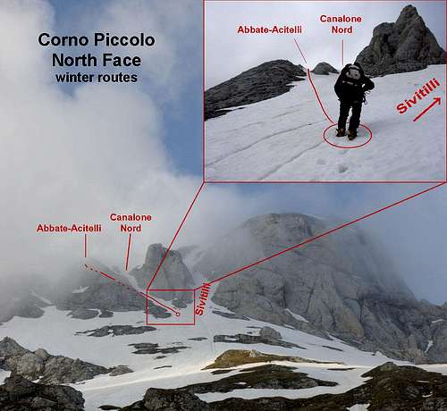
The Abbate-Acitelli couloir (Normal route from north) is a fork of the left branch of the evident “V” formed by the beautiful and evident Sivitilli couloir on the right, and Canalone Nord on the left. So the start is shared with Sivitilli and Canalone Nord couloirs.
- Directly from Prati di Tivo
From Prati di Tivo, you have to reach the start of these couloirs walking up the meadows on the right (west) of the chairlifts. You can climb through a couloir usually filled by snow until may, that leads to the clearly visible Sivitilli couloir, on the left of Prima Spalla. It takes about 2h 30min and 900m of elevation gain from Prati di Tivo parking.
- With Prati di Tivo Chairlift
As an alternative, from Prati di Tivo you can take the Arapietra chairlift: it leads you to Arapietra (1950m). From there, climb up the trail nr. 3 towards Passo delle Scalette and Franchetti Hut. When you meet a junction (about 2070m), take the trail on the right (Sentiero Ventricini) and follow it, passing under the base of north-east ridge of Corno Piccolo. The path traverses the meadows under Corno Piccolo north face, then arrives to the mouth of Sivitilli couloir, a wide couloir separating north face from Prima Spalla (about 45min from the chairlift arrival). From there, leave the trail and rise on the steep slopes, to the point where the couloirs start (about 2350m, 45min from the Sentiero Ventricini trail, 1h 30min from the chairlift arrival).
When the chairlift is closed, from Prati di Tivo main square you can drive until Sella di Cima Alta, following a route on the left (3,5Km from the square): from there (1650m), walk the trail rising up the wide and scenic Arapietra ridge, until you reach the chairlift arrival (about 1h).
Note: currently the chairlift is closed. It will be replaced by a new plant not before the autumn 2009.
I advise the climb directly from Prati di Tivo: it gives more gratification and permits an earlier start in the morning. The traverse from the chairlift arrival to the start of the couloir, along Ventricini trail, could be tricky and dangerous with many snow or ice.
Route Description
 Click to enlarge
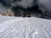
When you are under Sivitilli couloir, you can see, at the left of the rocky spurs defining the couloir, another evident gully: start climbing this couloir, on moderate slopes (35°/40°). After few dozens of meters the couloir splits in two: on the right, wider, there's Canalone Nord, on the left there's the narrower and not so deep Abbate-Acitelli (Normal route from north). Climb this couloir, that keeps a constant inclination of about 40°, for about 100/150m until you exit on the wide bowl below the Corno Piccolo summit (about 2500m). From there, bear on your right toward the ridge joining the Corno Piccolo summit with Prima Spalla, then follow the ridge to the top (2655m, about 1h from the start of the couloir).
Since many climbers can use this route to descend from Corno Piccolo main summit or from Prima Spalla summit, I’ll describe also the descent:
From the summit of Corno Piccolo, walk down the west ridge, toward Prima Spalla; before you reach Prima Spalla bear on your right (north) toward the rocky spur defining the left border (climbing) of Sivitilli couloir. Don't take the first wide couloir descending on the right of the rocky spur (this is Canalone Nord couloir), but take the little couloir, similar to a ramp, placed on the right. Descend it to the base of the couloir (reaching the start of the couloir takes about 15min from Corno Piccolo summit, 5min from Prima Spalla summit). Identify the start of the couloir from the top is not so easy if you haven't climbed it first: you could miss it, entering in the near Canalone Nord, that is steeper (45°)...
 From above From above |
 The start from above The start from above |
|---|
Essential Gear
In winter conditions (usually since november to early july):- crampons
- classic ice axe
- rope is usually not needed.
In summer conditions (usually since late july to october):
- A pair of good mountain shoes
- Rope could be useful if you take with you unexperienced hikers
In every season an helmet is heartily advised!
Guides, Map, External Links
Best guides:
L. Grazzini, P. Abbate, “Gran Sasso d’Italia”, Cai-Tci, 1992
S. Ardito, “A piedi sul Gran Sasso”, Iter, 1992
S. Ardito, “A Piedi in Abruzzo” vol. 1, Iter, 1996
A. Alesi, M. Calibani, A. Palermi, “Gran Sasso – Le più belle escursioni”, SER, 1996
Best map:
"Gran Sasso: Atlante dei sentieri - hiking atlas", edited by SER (scale 1:25.000) - very useful and convenient: advisable! -
“Gran Sasso d’Italia. La carta dei sentieri”, edited by Cai-L’Aquila (scale 1:25.000)
Weather conditions:
Meteo bulletin Meteomont: Abruzian Apennines
Weather in Pietracamela (by 3BMeteo)
Webcam:
Corno Piccolo north side from Prati di Tivo (on the right, Prima Spalla NE face)
More info and useful links in the Gran Sasso range page