
-
 34092 Hits
-
 80.48% Score
-
 12 Votes
|
|
Route |
|---|---|
|
|
46.20280°N / 121.4894°W |
|
|
Mountaineering |
|
|
Spring, Summer |
|
|
One to two days |
|
|
Moderate |
|
|
III |
|
|
Adams Glacier - Mt Adams' North Face
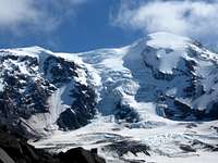
Adams Glacier
The Adams Glacier is Mt Adams' North Face. More of an icefall tumbling down between two rock ridges than a true face, it offers moderately steep ice climbing on an accessible part of the mountain. The proximity of the Northside to the population centers of Puget Sound makes for a much shorter drive than the South Side if you are coming from the Seattle area.
For those with the appropriate skills and equipment, the Adams Glacier boasts a greater technical challenge and more solitude than the south side routes. The approach passes quickly through pleasant, dry pine forests. Campsites can be situated among beautiful meadows with plenty of running water. This is my favorite side of the mountain.

Camp sites below Adams Glacier
Steeper and more technical than the more popular South Spur route, it is still doable by most competent mountaineers with ice climbing experience. Climbers can expect a lot of moderately steep terrain punctuated by shorter, steeper sections that may require a belay.
The best time to attempt this route is late spring (after the road to the trailhead melts out) through early summer. Usually June - early July. Later in season will mean a more broken up glacier and more rockfall on the descent.
Although doable car to car in a long day, the camping is so pleasant it makes up for carrying a heavier pack. Two days allows for a leisurely approach hike and time to admire the alpine meadows.
Getting There
From Randle, Washington on US 12, east of I-5, drive 32 miles on road 23. Turn left on road 2329, past Taklakh Lake in 2 miles, reaching the trailhead in 5.7 miles.
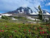
Meadows below Adams Glacier
Hike the Killen Creek trail 5.5 miles to the first campsites in the meadows. Campsites can be located close to the glacier, next to a small lake, allowing you to sleep in a bit longer in the morning.
Route Description
The nature of the route, a giant icefall, means that the route may change considerably from year to year and throughout the season. The route one chooses to follow will largely be dictated by crevasses and seracs.
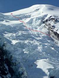
Upper part of route
The route ascends more than 5,000 vertical feet so get an early start. You want to be off of the Adams Glacier before the heat of the day starts causing icefall. It is easier to start in the dark than finish in the dark.
Begin climbing on low angle glacier at 7,000 feet. As the angle steepens the glacier will become more broken up and short, steep sections will be encountered. A good stategy is to stick to the right hand side until able to cut back left, high on the glacier to gain the summit plateau. The summit is reached after a long (1/2 mile) trudge across the high glacial plateau.
Descend via the North Ridge back to your campsite. The North Ridge is not technical, but is relatively exposed in places and has steep snow and loose rock. Take your time.
Essential Gear
Helmet
Ice axe
Ice hammer
Crampons
Rope
4-5 long ice screws
2 pickets
Rope
Harness
Crevasse rescue gear
Appropriate clothing
Camping gear
External Links
Link to a trip report by Loren and Hannah. The photos nicely depict some of the challenges one can expect on the route. Adams Glacier Trip Report
Another nice trip report: Adams Glacier Trip Report
Additional resources
Good descriptions of the approach and route can be found in the following guidebooks:
Selected Climbs in the Cascades, Volume I Jim Nelson and Peter Potterfield.
Cascade Alpine Guide, Climbing and High Routes. 1: Columbia River to Stevens Pass. Fred Beckey. Published by the Mountaineers.
onerichards - Aug 13, 2014 7:26 pm - Hasn't voted
pickets vs screwsDepending on the season and snow conditions, I'd say 3 long screws and 4 pickets (distributed) would be ideal. Also, we camped at 7400, above the high camp which provided more time in the morning to get to the foot of the climb as the sun was coming up and off the glacier before it got too sloppy and warm.
chrisc - Jul 9, 2022 5:55 pm - Hasn't voted
July 2022 Trip Report + BetaWe used 5 pickets and zero screws (but I would still carry screws). We left 1 picket behind when rapping into a crevasse.

Full July 2022 trip report and beta here