History
I had just finished my junior year of high school. On June 24, 1976, my dad dropped me off at Adirondack Loj for a solo day trip to the summit of Mt. Marcy, the highest point in New York. It would have been more memorable as a father-son hike. I guess he just wasn’t up to the challenge. I recall it being a warm and somewhat hazy day. I enjoyed the adventure. It was the first time in my life I had hiked above the tree line.
Shortly after graduating high school, I returned to the high peaks with my friend Mike. Our objective was to “bag” as many of the peaks as possible in a 5-day backpacking trip. We succeeded in capturing 12 summits in the five days, primarily in the McIntyre and Great Ranges. In those days, it was still legal to camp at Lake Tear of the Clouds, and there was a great lean-to that we called home for a night. The Lake Tear lean-to has been gone at least 30 years.
I returned to the high peaks fairly frequently during 1977-1979. My friend Paul and I summited Marcy on New Year’s Eve, 1978. There were a couple of failed attempts of Redfield and Santanoni on the way. The trailless peaks were really trailless back then, and apparently my navigational skills weren’t as good as they could have been. On July 14, 1979 I recorded completing my 25th high peak at Sawteeth. Little did I know that I wouldn’t climb a new ADK high peak summit for another 29 years.
We moved to Idaho, Wisconsin, Maine, and then Florida. Though we occasionally returned to vacation in the Adirondacks, the drive to complete the 46er list had escaped me.
In 2006, we moved to Delaware. Now only 7 hours away instead of a plane ride, we started venturing back to the Adirondacks more frequently. In 2008, I said to myself, “you aren’t getting any younger”. Time to get back to exploring the high peaks!
I climbed Dial for No. 26 on May 29, 2008. It felt good to be back at it. The opportunities only presented themselves once or twice a year, but I kept plugging away at the list. My good hiking buddy Jim accompanied me for several of these climbs. At the end of 2014 I realized I had only four more left to complete the journey. Which brings us to the present day.
Redfield and Cliff – May 24
Jim and I departed the Upper Works parking lot at 6:30 AM via the Calamity Brook Trail. It was a beautiful clear day with the temperature in the upper 40s. We leap frogged up the trail with Jillian and her dog Madison, who had the same two objectives today. The trails were mercifully quiet for Memorial Day weekend. We eventually reached scenic Lake Colden and followed the Opalescent River to the Uphill Lean-to.
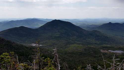
At the lean-to site the “trailless” route for Redfield and Cliff turns right at a large rock cairn. I put trailless in quotation marks. The 46ers have done an excellent job standardizing a single herd path to the summit of each trailless peak. One needs some trail sense, but generally these are well constructed and fairly easy to follow. After a few minutes, we took the left fork and started ascending Mt. Redfield (4606 ft.). The trail follows a stream and is frequently in and out of the stream bed. Eventually we left the stream and climbed more steeply to the wooded summit. It took about 1h15m from the marked trail junction to the top. Views from the top were nice and included Allen Mtn., which I would be visiting later in the week. It clouded up and spat a few drops of rain, but was still clear underneath the clouds. We descended the stream bed. At my advanced age, I was happy I had invested in trekking poles for the descent. A single pole definitely helped my stability!
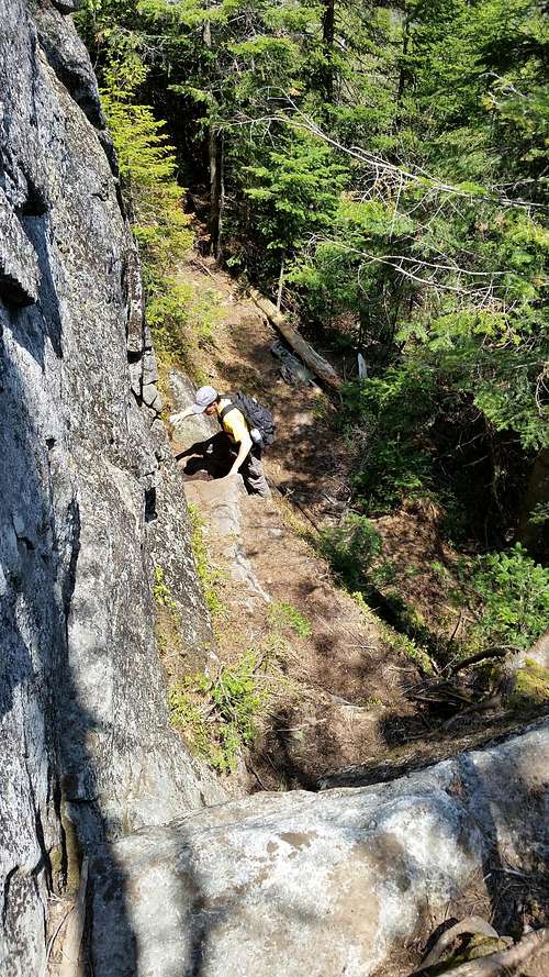
We saved Cliff (3960 ft.) for second because we thought that would be the easier climb! Wrong! After a short, very muddy section, we reached the base of Cliff. The mountain is aptly named. The route ascends for about 500 ft. up the face. Luckily it was dry and this made for some fun Class 3 scrambling. It would have been very challenging if the rock was wet. Upon reaching the top of the cliff, we knew we were only at a false summit. It required another half mile of ridge walking to get to the true summit. There were decent views and the sun was back out. It took about an hour from the trail junction to this point.
You may be curious how a 3960 foot mountain made it onto a list of 4000 ft. plus peaks. The tradition keeps the summit elevations that were known in 1925, when Marshall Brothers and Herbert Clark were the first to ascend all of the mountains. A 1953 survey lowered the heights of four of the peaks slightly below 4000 feet, but the tradition remains.
We gradually made our way back down the mountain, back to Lake Colden, and returned to Upper Works via the same route. Arriving at the car at 7 PM, it took 12.5 hours for a bit over 19 miles. No bugs the entire day until the mosquitoes got to us in the parking lot. Peaks 43 and 44 in the record book!
![Climbing Cliff Mtn.]() Climbing Cliff Mtn.
Climbing Cliff Mtn.Allen – May 26
Jim headed home on Monday. I took the day to recover from our exploit. On Tuesday I was up at 4 am again for the 75-minute trek from camp to Upper Works. Today’s destination was the East River Trailhead for a solo attempt on Allen Mtn. (4340 ft.) Allen is arguably the most remote and perhaps most feared of all Adirondack peaks. More on that later. There was only one other vehicle in the parking lot. By 6 AM I had my pack hoisted and was headed down the trail. The early part of the route is much improved relative to what others have had to recently endure. A new foot bridge has been constructed across the Hudson River, avoiding a serious ford. A nice trail route around Lake Jimmy has turned the prior swamp wading exercise into an enjoyable lakeside romp. The approach was long, mostly flat, and enjoyable. It drizzled intermittently during the early part of the journey. The forecast for later in the day was quite good.
At about 4 miles I encountered my first obstacle, fording the Opalescent River. Though only mid-calf deep, I was glad I brought a pair of old running shoes for the ford. I didn’t want to choose between slipping barefoot on river rock or soaking my boots for the rest of the trip. After the ford I stashed my running shoes in the woods for the return, donned my boots again, and continued.
A sign at a little over the 5 mile mark indicates “Allen”. Easy enough to find. The recently improved herd path was a pleasant walk through upland forests. It gained a bit of elevation over a col, then dropped again. Eventually I made my way to Skylight Brook. I had no difficulty crossing the stream. At this point I was four hours and about 8 miles into my journey.
Now the fun began. The route started by climbing gradually, and then gained with increasing steepness. It’s said that the last mile gains 1700 feet. That would make an interesting scramble, except for the fact that much of it is on or near the same rock slide occupied by Allen Brook.
Much has been written about the red slime of Allen. I am here to tell you it is real. Wet, steep, algae-covered rocks do not instill confidence in solo climbers. Luckily I was prepared and brought out my trusty Yaktrax. Without some sort of traction device I would have had to turn around. Progress with my Yaktrax and trekking pole was slow but steady. Eventually I was grateful to leave the slide completely and head steeply to the left up to the summit ridge. It took about 2 hours to reach the summit from Skylight Brook.
The weather had cleared and the views were tremendous. I had clear views of the Great Range, the Dix Range, Upper Ausable Lake, and all the way over to Giant and Rocky Peak Ridge. I hadn’t seen anyone else so far the whole day. After a brief respite it was time to cautiously descend, back into the slime zone. I went slowly but safe. Towards the bottom of the slide I came upon two other climbers headed up. They were the other car at the parking lot, having broken camp after I left. I cautioned them on the slime and continued down.
I gradually made my way back to the trailhead via the same route. The river ford felt a bit more refreshing and less bone-chilling than it had in the morning. After a total 12.5-hour journey I was back at my car. Mileage estimates are between 18 and 20 miles. I’ll lean towards the higher number for the effort required to get up and down the slide. This may have been my most difficult high peak. On the plus side, it was again a pleasure to hike in May in upstate NY with essentially no biting insects the entire day. It’s something to hike for over 12 hours and only encounter two other people. No. 45 in the books!
![Allen Mtn. from Mt. Redfield]() Allen Mtn. from Mt. Redfield
Allen Mtn. from Mt. RedfieldMarshall – May 29
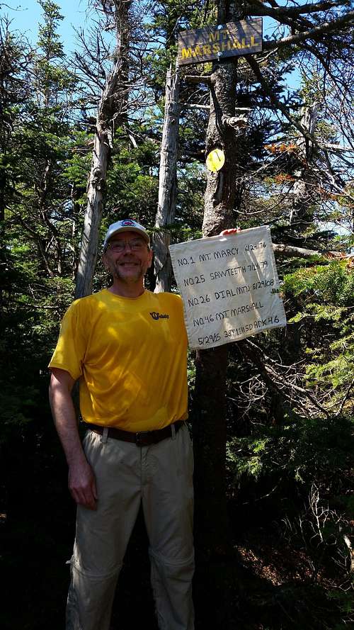
I had two reasons for saving Mt. Marshall (4360 ft.) to last. One, it wasn’t the most difficult of the trailless peaks. I wanted some time to relax and reflect on the summit. Secondly, it is named to honor Bob and George Marshall. The Marshall Brothers, along with their guide Herbert Clark, were the original 46ers, completing their quest in 1925. Now thousands have followed. It seemed fitting to honor the pioneers with this as my final peak.
After another early rise, I was back to Upper Works and the Calamity Brook trail for another solo hike. I was on the trail at 6:10 AM. I knew exactly where the Marshall route began, since we had passed it on the way to Redfield and Cliff five days prior. The route follows Herbert Brook up the mountain. This ravine looks more like a Pacific Northwest rain forest than Northeastern Spruce/Fir. It was a delightful and not difficult climb. The route crosses the brook several times, but these were mostly adequately marked with rock cairns. At one brook crossing I caught up to and passed another solo climber, making Marshall his 42nd peak. The trail continues to trace the brook until its source in a depression, almost on the ridge. The route then turns left and climbs through the woods to the summit. It was never very steep and I made good time. I was on the summit about 1.5 hours after leaving the trail junction, at 10:25 AM.
Time for celebration. A journey of nearly 39 years was complete. Well, of course I still had to safely get back down the mountain. Shortly thereafter, George from Syracuse made the summit. In addition to the other fellah, this was also his 42nd peak. We took photos for each other and exchanged stories. We had limited views of Iroquois Peak and could see Lake Placid in the distance. This was the only time the whole week that the bugs became bothersome. All of a sudden the black flies were swarming and quite hungry. This limited my desire to spend a lot of time on top to about 40 minutes. Before I left, the third climber had joined us as well.
I made it safely back down to the marked trail. It was warm, breezy, sunny, and once again bug free. I decided to relax at the “beach” at Flowed Lands for a while and contemplate my journey. In time I decided to get moving again. At about 9.5 hours and 13 miles total, I was back at the trailhead.
Three great days in the high peaks, four mountains climbed, a long-held desire realized, and I can list all forty-six of the Adirondack high peaks in my record book. At 38 years, 11 months, and 5 days, I expect I am more than a few standard deviations away from the norm on start to finish completion time!
![Mt. Marshall Summit]() Mt. Marshall Summit
Mt. Marshall Summit


Comments
Post a Comment