
Comments
No comments posted yet.
|
|
Trip Report |
|---|---|
|
|
44.11313°N / 73.9235°W |
|
|
Oct 12, 2013 |
|
|
Hiking |
|
|
Fall |
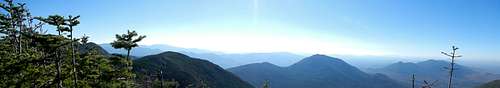
Drove down to the Adirondacks from Ottawa on Friday night to meet up with a buddy of mine at the accMontreal camping area in Keene. Beautiful night. Star were out as we discussed our route for the next morning. With the fall colours out in full force, we both agreed we had to do a hike with a view. Like two idiots, we couldn't make up our minds so we only decided to head to the Loj for 6am and go from there. At 6h20, we hit the trail with our headlamp on and headed toward Marcy dam. Within 20 min., our lamps were off and back in our packs. On the way to the dam, we decided to head for Cliff and Redfield, I had read in the Adirondack 46er book that Redfield had some nice views on the way up. Once at Marcy dam, we headed toward lake Arnold and through the swamps on our way the Uphill lean-to. It was about 10 o'clock now as we were making our way up Redfield and as the book had said, we got some great views once we got onto Uphill brook. Once off the brook, we really didn't get an other view except for the few times where the alpine trees were small enough that we could see over them. Once at the top of Redfield, we to a picture, a 5 minute snack and back down we went to the cairn that connects the two herb paths (1 to Redfield and the other to Cliff).
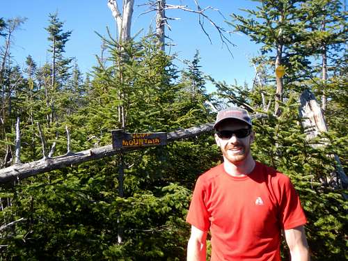
For those who are like me and love slides and scrambles, the way up Cliff was a blast. Full of short but fun little scrambles, that short section up the mountain is my definition of fun mountain climbing. Once we got on top of the ridge an other 15 minutes of flat terrain walking got us on top of Cliffs actual summit. Again, a picture and a snack were in order before we walked back down to Uphill lean-to. At 1h30, we got back at the lean-to and decided we had plenty of time left to go up Marcy before going down the other side to the Loj. We headed up towards lake tear of the clouds which I was seeing for the first time ( the other time, we were in the clouds). At 4300', the lake stands in the valley between Skylight, Grey and Marcy and at this elevation, it was kind of funny to me to think that this much water can accumulate to form a lake. On we went up on Marcy for what would be our last photo / snack break of the day.
On top of Cliff
After soaking up the view for a few minutes, we headed back down and gave ourselves a challenge to be back at the car before darkness. Down the long trail back to Marcy dam, we walked by the junction to Tabletop and then the one to Phelps to finally arrive at the dam at around 6. My partner then decides to get an extra workout out of his day and start jogging his way back to the car. I walked pasted a few groups heading back to the same spot I was going and while I'm singing songs to myself, I start to realize that I might need to pull out my headlamp to finish this hike. I stubbornly decide to walk-on when all of a sudden, I see the parking lot in front of me. At 6:45 I now needed my lamp to sign out the registration book at the Loj. After close to 12 and a half hours in the Adirondack we figured we traveled close to 23 miles and my watch said we had a total ascent of 6100'. What a great hike this was and probably the longest one until April comes around.