We know of this mountain that in very ancient times it was known as "Mons Gales" (see 16th century papers by the Mercator and by the Piedmontese Giacomo Gastaldi "The Great Alps in the cartography of the past centuries 1482 - 1865 with the itineraries of the passes between the Val d'Aosta, the Savoy and the Valais and considerations on the Gran Paradiso area", Priuli and Verlucca Editors, Ivrea, 1974. While the toponym strong>"Galisiaca" appears in Abbone's will of 739 (!) And, later in time, we also find those of "Galise o Galese", but facing the Colle del Carro and not the Passo di Galisia. In all that vast area that was generically known as "Mont Iseran", well before the "Gran Paradiso" was "born". Probably the radical, etymologically speaking, was the same "ise " and addressed a to the Isère Valley in Haute-Savoie. But there are also the toponyms of "Galice and which, among the inhabitants of Ceresole, is known as "la Galesia". To complicate matters more (but instead everything is very simple) appear the terms of Basei and Busson, as early as 1800 (see "GUIDE to the WESTERN ALPS VOL. II Graie and Pennine - PART TWO," , by Giovanni Bobba and Luigi Vaccarone with Publication of the Turin Section of the Italian Alpine Club, 1896, pages 131, 139 and 150 for Basei and pages 139, 151 for Bousson as well as pages 127 and 139 for Galisia ) "revolved" to the two Northern Peaks of Galisia. But in Valsavaranche, as early as 1767, the bull's head was cut more "briskly" calling with the term "Galise" the entire topographical node consisting of the large one wall below and common to the three peaks. And it is from here that we start for the mountaineering history of the South-Eastern Side, which sees the debut on this great wall that unfolds from Col Basei towards the South reaching the Passo della Galisia. Of the Basei by Giovanni Bobba with the local Guide Casimiro Thérisod, while on August 15th the following year the first, together with Luigi Cibrario and Luigi Vaccarone as well as always with Mountain Guide il Thérisod, traced an elegant itinerary on the SE Spur of Punta Bousson (almost not using the rope). To reach the wall below Punta Galisia, B&V also generically refer to a possibility of ascent for the SE side on page 138 "... f) For the south-east side. - ...", following the road to Colle Bousson then, leaving the SE Great Rib, cross to the left through rocks and canals and ... "you can reach the snowy north ridge of Galisia." . So the discours opens towards that great wall that opens to the left towards the Passo di Galisia, imitated on August 15th by the party roped of Ettore Ghiglione, Adolfo Hess, Pierinio Paissa which is nothing more than the repetition (or consists of the first ascent of a ascension only supposed, as often happens in the aforementioned guide june 1896 by B&V) of the previous route generically described, always by excellent Torino mountain writers Giovanni Bobba & Luigi Vaccarone .
Di questa montagna sappiamo che già in tempi molto antichi fosse conosciuta come "Mons Gales" (vedi carte del XVI secole del Mercatore nonché del piemontese Giacomo Gastaldi "Le Grandi Alpi nella cartografia dei secoli passati 1482 - 1865 con gli itinerari dei valichi tra la Val d'Aosta la Savoia e il Vallese e considerazioni sulla zona del Gran Paradiso", Priuli e Verlucca Editori, Ivrea, 1974. Mentre il toponimo "Galisiaca" appare nel testamento di Abbone del 739 (!) e, più in là nel tempo ritroviamo anche quelli di "Galise o Galese", ma rivolti al Colle del Carro e non al Passo di Galisia. In tutta quella vasta area che veniva genericamente conosciuta come "Mont Iseran", ben prima che "nascesse" il "Gran Paradiso". Probabilmente il radicale, etimologicamente parlando, era il medesimo "ise" e si rivolgeva alla Valle dell'Isère nell'Alta Savoia. Ma si riscontrano anche i toponimi di "Galice" e che, tra gli abitanti di Ceresole, viene conosciuta siccome "la Galesia". A complicare maggiormente le cose (ma invece il tutto é molto semplice) appaiono i ermini di Basei e Busson, già dal 1800 (vedi "GUIDA delle ALPI OCCIDENTALI VOL. II Graie e Pennine - PARTE SECONDA, ", di Giovanni Bobba e Luigi Vaccarone con Pubblicazione della Sezione di Torino del Club Alpino Italiano, 1896, pagine 131, 139 e 150 per Basei e pagine 139, 151 per la Bousson nonché pagine 127 e 139 per la Galisia) "affibbiati" alle due Vette a Settentrione della Galisia. Ma a Valsavaranche, già dal 1767, in modo più "spiccio" si tagliava la testa al toro chiamando con il termine di "Galise" l'intero nodo topografico costituito da quella grande muraglia sottostante e comune alle tre cime. Ed é da qui che partiamo per la storia alpinistica del Versante Sudorientale, che vede l'esordio su questa grande parete dispiegantesi dal Col Basei verso Sud raggiungendo il Passo della Galisia. L'esordio avviene l'8 Agosto 1889 con il Versante SE della Basei ad opera di Giovanni Bobba con la guida locale Casimiro Thérisod, mentre a Ferragosto dell'anno successivo il primo, insieme a Luigi Cibrario e Luigi Vaccarone nonchè sempre con Guida il Thérisod, tracciavano un elegante itinerario sullo Sperone SE della Punta Bousson (quasi non utilizzando la corda). Per giungere al muro sottostante la Punta Galisia, sempre B&V riferiscono genericamente di una possibilità di salita per il Versante SE in pagina 138 " ... f) Pel versante sud-est. - ...", seguendo la via per il Colle Bousson per poi, abbandonando la Costola SE, attraversare verso sinistra tramite rocce e canali e ... "si riesce sulla nevosa cresta nord della Punta Galisia." . Dunque si apre la porta verso quella grande parete che si apre verso sinistra in direzione del Passo di Galisia, imitata a Ferragosto dalla cordata di Ettore Ghiglione, Adolfo Hess e Pierinio Paissa che altri non é che la ripetizione (oppure consistente nella prima salita di un'ascensione solamente supposta da B&V, come spesso avviene nella citata guida del giugno 1896) della precedente via genericamente descritta, sempre dall'eccellente accoppiata di scrittori di montagna torinesi Giovanni Bobba & Luigi Vaccarone.
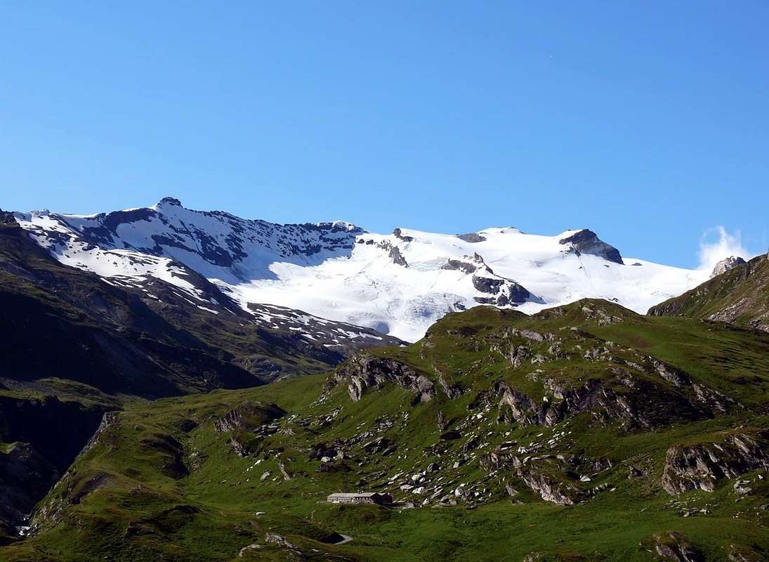
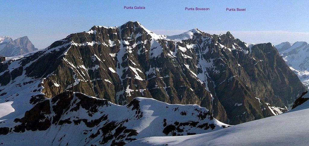
Last and important topographin knot between the valleys of Rhêmes (Valle d'Aosta), Orco's Vallry / Ceresole (Piedmont Region) and Isère (France). On its Northwestern side a wide glacier while its Souteast and South sides comes down with two huge rock walls. Of these three different sectors we will carry out a detailed analysis describing, in a clockwise direction, first the ascent routes along the Northern side starting from the route of September 1886 ( by William Auguste Brevoort Coolidge with Swiss Mountain Guide Christian Almer Junior), then those of the SE Face (starting from the end of the nineteenth century and up to the first twenty years of the twentieth century with the roped Ghiglione-Hess-Paissa of august 1919) and finally concluding with the Southern ones concerning Val d'Isère, as well as consisting of the first ascent route to the mountain of 17 August 1888 (Hoelis-Yeld-Payot-Martin) through the Southwestern side, starting from the Galisia Pass.
L'estremo nodo e punto topografico importante tra le Valli di Rhêmes (Valle d'Aosta), Ceresole (Piemonte) e d'Isère (Francia). Si presenta con un versante glaciale a Nordovest e due pareti rocciose a Sudest ed a Sud. Di questi tre diversi settore effettueremo un'analisi dettagliata descrivendo, in senso orario, dapprime le vie di salita lungo il Versante Settentrionale partendo dalla via del settembre 1886 (Coolidge-Almer Junior), quindi quelle della Parete SE (iniziando dalla fine dell'Ottocento e fino al primo ventennio del Novecento con la cordata Ghiglione-Hess-Paissa dell'agosto 1919) per infine concludere con quelle Meridionali concernenti la Val d'Isère, nonché consistenti nel primo itinerario di salita alla montagna del 17 Agosto 1888 (Hoelis-Yeld-Payot-Martin) per il Versante Sudovest, partendo dal Passo di Galisia.
Getting There
From France: through the Mont Blanc Tunnel or the Col du Petit Saint Bernard: you can drive on SS.26, following directions for Aosta and, before arriving in Villeneuve, turn right towards Introd. Alternatively, you can take Motorway A5 (at Courmayeur or Morgex) and exit at Aosta Ovest.
From all the other directions: get to the Aosta Ovest exit of Motorway A5. Then drive on SS.26 Aosta, in the direction of Courmayeur; just after Villeneuve turn left towards Introd.
BY PLANE:
Aeroporto "Corrado Gex" Saint Christophe (Aosta).
Enter the valley and, at the fork between Valsavarenche and Val di Rhêmes turn to the right (Rhêmes). Cross all the villages to arrive to Rhêmes Notre Dame and follow to Thumel Hamlet (car parking), herefrom, following the dirt road on the right side (ascending) of the valley, or, better with snow, a track on the left that passing throught some fine woods leads you to the Rifugio Federico Benevolo (2.285/7m).
All Routes Various Descriptions
VARIOUS ROUTES
A) - From North Routes As regards the characteristics and the technical difficulties with respect to the various climbs, it should be noted that Punta Galisia does not offer extreme level itineraries neither on rocky field nor on glacial ground ; rather, it offers beautiful ski-mountaineering climbs completely along the Lavassey (below Basei and Bousson Western Sides) or Fond Glaciers, both in their Eastern branch, on the Italian side of Rh & ecirc; mes and the Glacier de Basagne in the upper Val d'Isère, just above the tiny Glacier de Galisia. Despite some accurate recommendations we must make it:
1) - always pay absolute attention to the state of the glaciers that can hide unexpected crevasses, even where you least expect it. The "Valdostano-Rh & ecirc; mense" Glacier Oriental de Fond (the one on which the ascent was made in September 1886) stretches towards the SE starting from the altitude of (about 2.776/2.800 meters), between the NW shoulder of P. Bousson (3.337m; the characteristic one for the two yellowish gendarmes in view also from Benevolo Refuge), Col de Basagne (3.110m) and N-NE Face of Roc de Basagne, from bases at an altitude of 2.800/2.977 meters. Of a "good-natured" aspect, it should not be underestimated (F/F+).
2) - the other possible route climbs up towards South with path n° 13 to Colle Basei (3.176m) leaving the same where it splits for Col Nivoletta (or Nivolettaz; 3.130m) and moving to the adjacent in South Lavassey Glacier at an altitude of approximately 3.000/3.020 meters, just before that the same it presents a steeper ramp towards the ascent to the hill . Here it is worth giving important information: the route in the center of the plateau is really dangerous, especially in the hottest hours (from personal experience on October 4th 1986 at about 2.00' pm on the return from Galisia and on the shoulder of the Punta Bousson we saw the center of the glacier explode with a cannon shot and the relative opening of a rounded hole with a diameter of about twenty meters), right there where we were in doubt whether to pass or redo the archway at the base of Western Face of Punta Basei); It is certainly worth staying more up a good hundred meters. Widening the arc and passing to the bases of West Wall of Basei (3.338m) and North Face of Bousson. To then go up to the West almost at the end of the NW shoulder between the 2.955 heights/3.141 meters and cut diagonally to the Top, aiming at the rounded yellow-orange rock, just below the Summit (from F+ or a little more than Easy to PD-).
3) - Or, climbing the snowy ridge / edge of the Northwestern shoulder (from F+ to PD), anticipating the ascent to the East of the yellowish bifid rocky tooth (one high and the other medium-low as well as such as to make them appear as the article "the" or Cric & Croc), to the nearby Punta Bousson (3.337m) and
4) - then cross the watershed edge with NE Ridge in final part (August of 1888 Route), but bypassing just to the right (South) the adjacent Punta Bousson. But also
5) - in a complete aerial traverse between Punta Basei, Punta Bousson and Punta Galisia, as the Osvaldo Cardellina and Marco Cossard team did, in the South / North direction and therefore "downhill" from the last one, on 30 September 1980, after having climbed the Southeastern Couloir precisely of Punta Galisia above Pian della Ballotta (2.577m) with a beginning an altitude of around 2.756/2.760 meters up to the final part of SW Ridge. All these routes, except the last but included if it occurs exclusively for the crossing, have in common, as their starting point, the Federico Benevolo Refuge (2.285/7m); or, if carried out during the day, the start takes place at the beginning of the path just after Thumel (1.903m; extensive signs and reports on pannel). In any case, this itinerary is certainly the most used, not only on the Italian side, for the ski-mountaineering ascent and no eclusively to Punta Galisia, but also to Punta Bousson, with the ascent through the Glacier de Lavassay, under Punta Basei, and Northwestern shoulder up to the watershed. As far as the complete crossing of the three summits is concerned, there are no other ascents (from PD- to D-, depending on the stretches of route). All of this, logically, refers to an integral and complete path including the great gendarme, which is usually bypassed, together with other bypasses, on the Eastern Slope (as per "CAI Bulletin 1889", p. 53. Otherwise the crossing takes on another evaluation with: (from PD- to PD+, depending on the stretches of routes). It should also be noted that the itinerary for the O-NW border Ridge (see point n° 13), from Col Basagne (3.110m) taking advantage of the the extremity of the homonymous glacier, can also be carried out from the Northern side, albeit with a not very rational choice, but still possible.
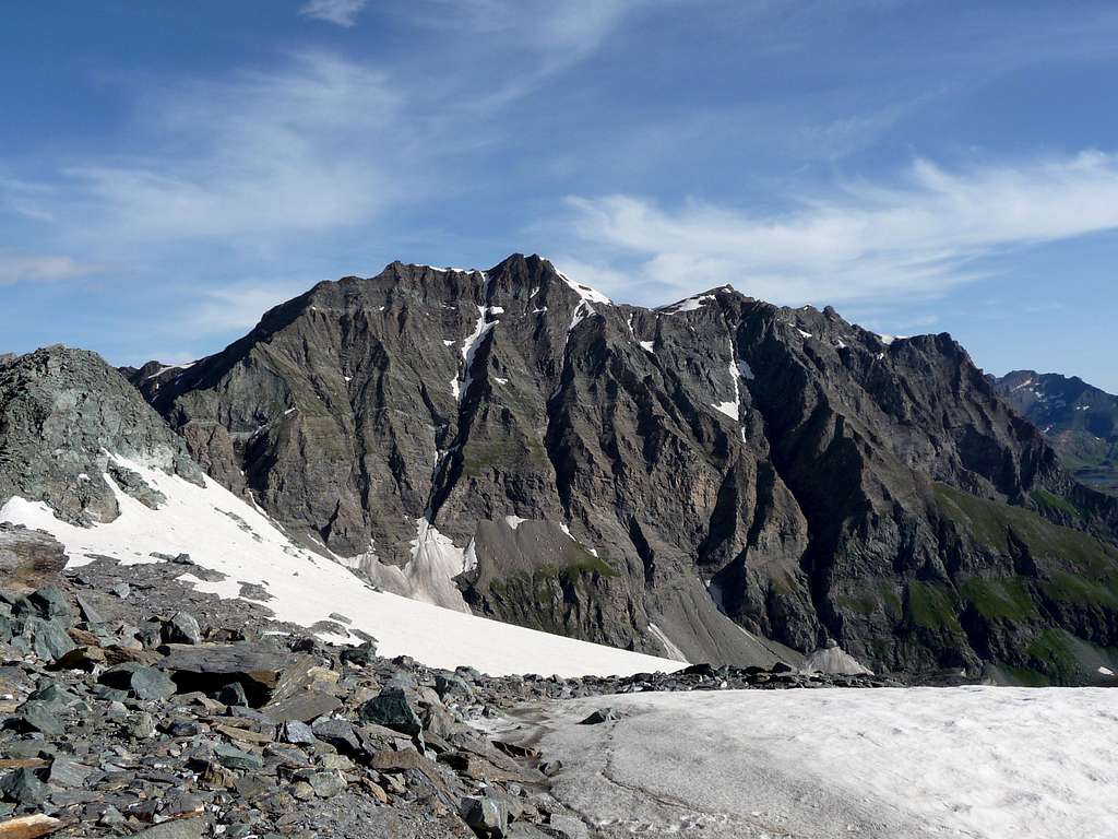
B) - From South Routes Passing on the other or Southeastern side, facing above the terminal part of the Valle dell'Orco (Pian delle Gavite under the Bousson and Pian della Ballotta under the Galisia), it should be emphasized that the routes on this side, either on rock or in snow, they are dangerous.
6) - Both the primitive route on the SE Rib of Punta Bousson and crossing to the hill of the same name (about 3.320 meters in B&V, page 151), to then conclude with the North Crest (described by B&V in "Guide to the Western Alps" , 1986, page 138: "f) For the south-east side.", by unknown ascenders; both the old street
7) - of 15 August 1919 by Ettore Ghiglione, Adolfo Hess and Pierino Paissa (as per "Monthly Magazine of the CAI", 1921, pp. 1-6) with a similar itinerary using the via alla Bousson di Bobba, Cibrario and Vaccarone of 15 August 1890 and then traversing to the left on rocky ribs and snow-covered canals in the last part, are to be considered as "archaic" and never repeated. The difficulties can reach, with a bottom-up and therefore approximate analysis, at most the III °, but what is necessary is to know how to decipher the path (certainly dangerous in the end because possible stones falls). Two more recent routes follow: the first
8) - of 13 August 1970 by Enrico Marta and Giorgio Viale crosses the SE Spur-Crest, formed at the base by a brown-reddish rock trapezoid and then following the line on the vertical of the Vetta with passages from III° to V°, but almost all can be circumvented with less difficulty on very broken rocks, exiting in the final on the right (North) of the Summit (itinerary that is not again repeated, completed in 4h'30 and with the use of 5 pitons, of which 2 left on site). This climb, exclusively in rock, can be roughly evaluated in from AD-/AD/AD + up to D-/D, depending on the passages chosen and performed, because many are avoidable, alternatively on both sides.
9) - The second of 30 September 1980 by a group of mountaineers from Aosta Osvaldo Cardellina and Marco Cossard, which directly passed the rocky-snowy gully immediately to the left of the previous itinerary with a climb completely on ice of almost 650 meters, slopes from 35°/40° to almost 50°/60° (a very dangerous passage in the narrow gully that forms after about 250 meters and one at 60 ° in the very narrow and dangerous gully in the last about 100/20 meters) and exit out just South of the Top along the short final part of SW Ridge. On the occasion, then, they crossed, thus bypassing the Summits of Bousson and Basei, up to Colle Basei (3.176m). The departure for all these itineraries should be made from the Pian della Ballotta Refuge (2.440m), just West of Lake Serrù; but also, if you wish and arriving from Pont Valsavarenche, from the Città di Chivasso (2.600m) or Savoia (2.610m) Refuges at Colle del Nivolé (2.612m) with subsequent short descent towards Agnel Lake (2.297m) and Serrù Lake (2.278m). In any case, climb to be evaluated in AD/AD+, but very dangerous and which results is no longer repeated.
C) - From South or Val d'Isère Routes Ultimately, the border crests with the SW between the Upper Isère Valley (French) and the terminal part of the Orco Valley in Canavese (Piedmont Region), or on the border between Italy and France. This watershed rises from the Galisia Pass (2.987/3.002m) to the Vetta and was traveled
10) - with a partial route more or less along the ridge and then in the upper part crossing to the left (West) towards the Glacier de Basagne and with this to conclude even if the choice of the path is not always easy to identify (presence of treacherous "ollina" grass). In any case ascent to be evaluated in F+/PD-/PD/PD+. However, it is the most popular route from Piedmont side, that is, coming from the Orco Valley in direction of Pont Canavese, Locana, Noasca and Ceresole Reale Municipalities.
11) - Or with a direct variant (to evalue in PD+/AD-) of the consortium of September 1970 which, remaining for the most part on the border, reached the Summit with passages from II°- up to the III°. Beyond the SW flank the first ascenders of August 1878 traveled north up the small Glacier de Galisia (unnamed in Italian cartography, as well as endangered) reaching the rocky wall at the base of Glacier de Basagne; through channels alternating with a series of ledges, on very broken rock and debris, they reached the upper part of Glacier de Basagne and with this the Cima. A path that is not easy to identify and one that requires a lot of attention in the choice of the passages, which the Camusso-Chiarabaglio-Cresto-Maggi roped faced the first tower on the edge of the same (about 8 meters of II°+, crossing to the left on the French side with a III° rocky plate); then it continued, returning almost immediately to the edge of the ridge using a rocky gully formed by a series of natural steps, taking 2h.00 'from the Passo di Galisia to the Summit, for a roped of certainly experienced mountaineers, as well as good connoisseurs of the territory.
12) - A variant was opened on this route in July 1904 - by Emilio C. Biressi and Mario Ambrosio who, through a difficult ledge on the Western Face and traveled from North to South, reached the Ante Summit located right at the junction of the SW and W Crests -NO. Probable difficulties from I°+ up to the III° for an "obsolete" and never repeated path. From an exclusively summary analysis, it is believed that this path could be evaluated in PD-/PD+/AD-.
13) - Good last the W-NW Crest that climbs without any difficulty from Col Basagne (3.110/22m) using the rump that forms the edge of the homonymous glacier, before, in bottom, bypassing the minuscule asperity 3142 meters, after ascending on Quota 3288 meters and through the terminal snowy slope (F).
14) - APPROACHES The logistic support points consist, as for point B, from the two refuges at the end of Pian del Nivolé or, better, from that of Pian della Ballotta (2.577m) for the SW Ridge if climbed from the Italian side; otherwise from the French Réfuge de Prariond (2.440m) starting from the Isère Valley one. All the other itineraries to follow always depend on this last one, sited at the foot of Grande Tête (2.702m). However, on the Italian side, the climbs are long but possible, even starting from Pont Valsavaranche (very wide parking in earth) or from the long parking always in earth along the Rhêmes's Doire just before the Thumel's Hamlet.
VARIE VIE
A) - Vie dal Nord Per quanto concerne le caretteristiche e le difficoltà tecniche rispetto alle varie salite, vi é da annotare come la Punta Galisia non offra itinerari di estremo livello né in campo roccioso né su terreno glaciale; bensì propone piuttosto delle belle salite di stampo sci-alpinistico percorrendo completamente (al di sotto dei lati Occidentali della Punta Basei e della Punta Bousson) i Ghiacciai di Lavassey o di Fond, entrambi nel loro ramo Orientale, sul lato italiano di Rhêmes ed il Glacier de Basagne nell'alta Val d'Isère, appena soprastante il minuscolo Glacier de Galisia. Ciononostante qualche accurata raccomandazione dobbiam effettuarla:
1) - prestare sempre assoluta attenzione allo stato dei ghiacciai che possono celare imprevisti crepacci, anche là dove meno te lo aspetti. Il "Valdostano-Rhêmense" Glacier Oriental de Fond (quello sul quale venne effettuata la salita nel settembre del 1886) si distende verso SE a partire dall'altitudine di (circa 2.776/2.800 metri), compreso tra lo spallone NO della P. Bousson (quello caratteristico per i due gendarmi giallastri in vista anche dal Rifugio Benevolo), il Col de Basagne (3.110/22 m) e la Parete N-NE del Roc de Basagne, dalle basi a quota 2.800/2.977 metri. Di aspetto "bonario", é comunque assolutamente da non sottovalutare (da F o Facile a F+).
2) - l'altra via possibile sale verso Meridione con il sentiero n° 13 per il Colle Basei (3.176 m) abbandonando il medesimo laddove si sdoppia per il Col Nivoletta (o Nivolettaz; 3.130 m) e trasferendosi sull'adiacente a Sud Ghiacciaio di Lavassey a quota 3.000/3.020 metri circa, appena prima che il medesimo presenti una rampa più erta verso la risalita al colle. Qui conviene dare un'informazione importante: il percorso nel centro del plateau é veramente pericoloso, soprattutto nelle ore più calde (per esperienza personale il 4 di ottobre 1986 alle 14.00' circa al rientro dalla Galisia e sullo spallone della Bousson abbiamo visto esplodere il centro del ghiacciaio con una cannonata e relativa apertura di un buco arrotondato dal diametro di circa una ventina di metri, proprio là dove eravamo in dubbio se passare o rifare il giro ad arco alla base della Parete Ovest Punta Basei); conviene sicuramente restare più in alto di un buon centinaio di metri. Allargando il giro ad arco e passando alle basi della Parete Ovest della Basei (3.338 m) e di quella Nord della Bousson. Per poi risalire all'estremità Ovest dello spallone N-O tra le Quote 2.955/3.141 metri (presso i due denti) e tagliare in diagonale alla Vetta, tenendo di mira il roccione giallo-arancione arrotondato, subito sotto la Cima (da F+ a PD-).
3) - Oppure, salendo per il filo di cresta nevoso dello spallone Nordoccidentale, anticipando la salita ad Est del giallognolo dente roccioso con forma bifida (uno alto e l'altro medio-basso nonché tali da farli apparire come l'articolo "il" oppure Cric & Croc), alla vicina Punta Bousson (3.337 m)(da F+ a PD), per poi
4) - attraversare sul filo dello spartiacque con la Cresta NE (Via dell'agosto 1888) (F+), ma oltrepassando subito a destra (Sud) l'adiacente Punta Bousson. Ma anche
5) - in completa nonché aerea traversata tra Punta Basei, Punta Bousson e Punta Galisia, come fece la cordata di Osvaldo Cardellina e Marco Cossard, nel senso Sud / Nord e quindi "in discesa" con partenza dall'ultima, il 30 Settembre 1980, dopo aver risalito il Canalone Sudorientale appunto della Punta Galisia sopra il Pian della Ballotta con inizio a quota 2.756/2.760 metri circa. Tutte queste, tranne l'ultima ma compresa se avviene esclusivamente per la traversata, vie hanno in comune, come punto di partenza, il Rifugio Federico Benevolo (2.285/7 m), oppure, se in giornata, l'avvio avviene all'inizio del sentiero subito dopo il Villaggio di Thumel (1.903 m; ampie segnalazioni su panneaux). In ogni caso questo itinerario é certamente il più utilizzato, non solo sul versante italiano, per la salita sci-alpinistica e no alla Punta Galisia, ma anche alla vicina Punta Bousson, attraversando il Ghiacciaio di Lavassey sotto la Punta Basei nonché tramite lo spallone Nordoccidentale fino al raggiungimento della cresta NE oppure spartiacque. Per quanto concerne la traversata integrale delle tre sommità non ci risultano altre ascensioni (da PD- a D-, a seconda dei tratti di percorrenza). Il tutto, logicamente, riferito ad un percorso integrale e completo compreso il gran gendarme, ch di solito viene aggirato, insieme ad altri aggiramenti, sul Versante Orientale (come da "Bollettino CAI 1889", pag. 53. Altrimenti la traversata assume altra valutazione con: (da PD- a PD+, a seconda dei tratti di percorsi). Inoltre va fatto osservare che l'itinerario per la Cresta di frontiera O-NO (vedi al punto n° 13), dal Col Basagne (3.110/22 m) sulla groppa costituente l'estremità dell'omonimo ghiacciaio, possa essere effettuato anche dal Versante Settentrionale, anche se con una scelta poco razionale, ma pur sempre possibile.
B) - Vie da Sudest Passando sull'altro lato o Sudorientale, rivolto al di sopra della parte terminale della Valle dell'Orco (Pian delle Gavite sotto la Bousson e Pian della Ballotta sotto la Galisia), é da sottolineare che le vie su questo versante, sia su roccia oppure in neve, sono piuttosto pericolose.
6) - Sia la primitiva via sulla Costola SE della Punta Bousson e traversata al colle omonimo (3.320 metri circa in B&V), per poi concludere con la Cresta Nord (descritta da B&V in "Guida delle Alpi Occidentali", 1986, pag. 138: "f) Per versante sud-est.", ad opera di salitori sconosciuti; sia la vecchia via
7) - del 15 agosto 1919 ad opera di Ettore Ghiglione, Adolfo Hess e Pierino Paissa (come da "Riv. Mensile del CAI", 1921, pagg. 1-6) con itinerario similare utilizzando la via alla Bousson di Bobba, Cibrario e Vaccarone del 15 agosto 1890 e poi con traversata non semplice e pericolosa a sinistra su costole rocciose e canali innevati nell'ultima parte, sono da considerare come "arcaiche" e mai più ripetute. Le difficoltà possono raggiungere, con analisi dal basso e dunque approssimativa, al massimo il III°, ma quello che é necessario consiste nel saper decifrare il percorso (sicuramente pericoloso nel finale per possibili cadute di sassi).
8) - Seguono due vie più recenti: la prima del 13 agosto 1970 ad opera di Enrico Marta e Giorgio Viale supera lo Sperone SE, formato alla base da un trapezio di roccia marrone-rossastra e poi seguendo la linea sulla verticale della Vetta con passaggi dal III° al V°, ma quasi tutti aggirabili con minori difficoltà su rocce molto rotte, uscendo nel finale sulla destra (Nord) della Vetta (itinerario che non risulta ripetuto, compiuto in 4h'30 e con l'uso di 5 chiodi, dei quali 2 lasciati in loco). Questa salita, esclusivamente in roccia, all'incirca può essere valutata in da AD-/AD/AD+ fino a D-/D, a seconda dei passaggi scelti ed eseguiti, poiché molti sono evitabili con aggiramenti, alternativamente su entrambi i lati, anche se, a volte, aumentano la pericolosità, soprattutto verso i due canaloni laterali ed in particolare sul destro.
9) - La seconda del 30 settembre 1980 ad opera della cordata di alpinisti aostani Osvaldo Cardellina e Marco Cossard, che superò direttamente il canalone roccioso-nevoso subito alla sinistra del precedente itinerario con salita di quasi 650 metri, pendenze da 35°/40° a quasi/50°/60° (un passaggio molto pericoloso nella strettoia del canale che si forma dopo circa 250 metri ed uno a 60° nello strettissimo ed altresì pericoloso canalino negli ultimi 100/20 metri circa) ed uscita appena a Sud della Cima nella parte terminale della Cresta SO. Nell'occasione, poi, i medesimi attraversarono, scavalcando quindi le Sommità di Bousson e Basei, fino al Colle Basei (3.176 m). La partenza per tutti questi itinerari conviene effettuarla dal Rifugio Pian della Ballotta (2.440 m), appena ad Ovest del Lago Serrù; ma anche, volendo ed arrivando da Pont Valsavarenche, dai Rifugi Città di Chivasso (2.600 m) o Savoia (2.610 m) presso il Colle del Nivolé (2.612 m) con susseguente breve discesa verso il Lago dell'Agnel (2.297 m) ed il Lago Serrù (2.278 m). In ogni caso salita da valutarsi in AD/AD+, ma molto pericolosa e che risulta non più ripetuta.
C) - Vie da Sud o dalla Val d'Isère In ultima analisi le creste di confine con la SO tra l'Alta Valle dell'Isère e la parte terminale della Valle dell'Orco in Canavese, ovvero al confine tra Italia e Francia. Questo spartiacque sale dal Passo della Galisia (2.987/3.002 m) alla Vetta e venne percorso con
10) - un percorso parziale più o meno sul filo di cresta per poi nella parte alta attraversare a sinistra (Ovest) verso il Glacier de Basagne e con questo facilmente concludere, anche se la scelta del percorso non appare sempre facile da individuare (presenza d'erba "ollina", infida). In ogni caso, da valutare in F+/PD-/PD/PD+. Risulta come la via più frequentata dal versante piemontese, ovvero provenendo dalla Valle dell'Orco in direzione di Pont Canavese, Locana, Noasca e Ceresole Reale.
11) - Oppure con una variante diretta (da valutare in PD+/AD-) della cordata del settembre 1970 che, restando per gran parte sul confine, raggiungeva la Sommità con passaggi dal II°- fino al III°. Oltre il Versante SO veniva percorso dai primi salitori dell'agosto 1878, risalendo verso Nord il piccolo Glacier de Galisia (innominato nella cartografia italiana, nonché in via di estinzione) raggiungendo la muraglia rocciosa alla base del Glacier de Basagne; tramite canalini alternati ad una serie di cenge, su roccia molto rotta e detriti, raggiungevano il Glacier de Basagne e con questo la Cima. Una via non semplice da individuare e tale da richiedere molta attenzione nella scelta dei passaggi, che la comitiva Camusso-Chiarabaglio-Cresto-Maggi affrontò, attaccando dal Passo di Galisia, sul filo il primo torrione (8 metri circa di II°+ e traversata a sinistra sul versante francese con placchetta di III°); quindi continuò ritornando quasi subito sul filo di cresta utilizzando un canalino roccioso formato da una serie di gradini naturali, impiegando 2h.00' dal Passo di Galisia alla Cima, per cordata di alpinisti sicuramente rsperti, nonché buoni conoscitori del territorio.
12) - Su questa via nel luglio 1904 venne aperta una più complessa che difficile variante da Emilio C. Biressi e Mario Ambrosio che, tramite una difficile cengia sulla Parete Occidentale e percorso da Nord a Sud, raggiungeva l'Antecima posta proprio alla congiunzione delle Creste SO ed O-NO. Probabili difficoltà dal I°+ fino al III° per un percorso "obsoleto" nonché mai più ripetuto. Da un'analisi esclusivamente sommaria, si ritiene che questo percorso potrebbe essere valutato in PD-/PD+/AD-
13) - Buon ultima la Cresta O-NO che sale senza difficoltà alcuna dal Col Basagne (3.110/22 m) sfruttando il groppone costituente l'orlo dell'omonimo ghiacciaio, dapprima, in basso, bypassando la minuscola asperità 3142 metri, quindi sormontando la Quota 3288 metri e finendo nella parte terminale innevata del pendio (F).
14) - AVVICINAMENTI I punti di appoggio consistono, come per il punto B, dai due rifugi al termine del Pian del Nivolé oppure, meglio, da quello del Pian della Ballotta per la Cresta SO se salita dal versante italiano; altrimenti dal francese Réfuge de Prariond (2.440 m) con partenza dall'Alta Valle dell'Isère. Tutti gli altri itinerari a seguire dipendono da quest'ultimo, collocato alle pendici della Grande Tête (2.702 m). Comunque sul versante italiano sono, lunghe ma possibili, le salite anche partendo da Pont Valsavaranche (larghissimo parcheggio in terra battuta) o dal parcheggio affianco alla Dora di Rhêmes appena prima del Villaggio di Thumel.
Essential Gear
Mountaineering equipment, including rope, iceaxe, and crampons.
Parents refers to a larger category under which an object falls. For example, theAconcagua mountain page has the 'Aconcagua Group' and the 'Seven Summits' asparents and is a parent itself to many routes, photos, and Trip Reports.

 1066 Hits
 79.04% Score
 10 Votes