
-
 953 Hits
-
 79.04% Score
-
 10 Votes
|
|
Route |
|---|---|
|
|
45.67846°N / 7.05061°E |
|
|
Hiking |
|
|
Summer |
|
|
E/F |
|
|
Overview
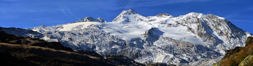
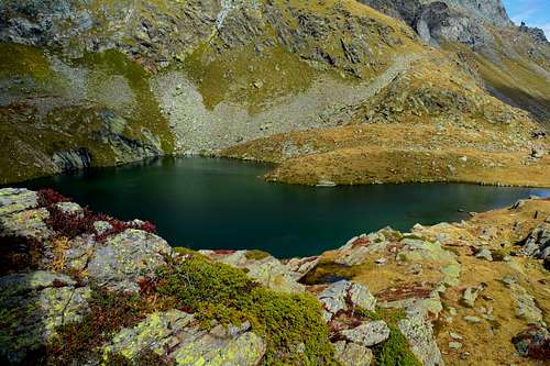
This isolated and trapezoid-shaped lake has two branches to the North-northoverst and East-northeast and one to the Southwest which, when viewed from above, give it the shape of a jellyfish. It is nestled below the watershed that connects Mont Pit (2.814m), to a large shoulder of the long Northeast Crest of Mont Paramont (3.300m), towards Colle delle Molette (2.774m) before the latter reaches the nearby Punta de la Crosatie (2.926m) and Col (2.826m) of the same name, all straddling the Valloni del Fond to the Southeast and d'en Haut to the Northwest. It appears to be the only and perhaps the last lake in the area of glaciers that from the Rutor Chain reach the Mont Paramont Group (3.300m); in fact, to find others we must go up to the two little lakes of Morion (2.883 and 2.909 meters), located at the foot of the Glacier de Morion, or on the slopes of the East Face of the Testa del Rutor or Ruitor (3.486m) from which start the along buttress that reaches Bec Taillà, Torre del Tighet or Tour du Tignet, Torre Tonda, Punte di Faveroy and Monte Colombo just above the Village of Baulin or Baulen. Beautiful hiking tour with splendid views of the Paramont Range and the Rutor Glaciers and Chateau Blanc in the South, while from the opposite side the view sweeps across the Becca di Tos Group (3.300m) to the other watershed of Valgrisenche. This excursion is also suitable for groups with children (but paying attention to the first part of the route), being almost devoid of any danger.
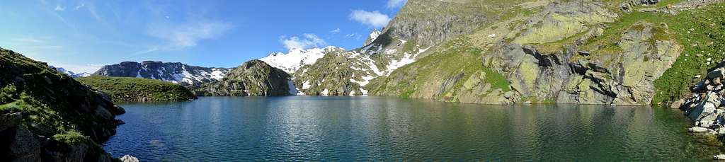
Questo lago isolato e a forma di trapezio presenta due ramificazioni a Nord-nordoverst ed ad Est-nordest ed una a Sudovest che, se osservato dall'alto, gli danno la forma di una medusa. Si trova incastonato al di sotto dello spartiacque che collega il Mont Pit (2.814 m), grosso spallone della Cresta Nordest del Mont Paramont (3.300 m), al Colle delle Molette (2.774 m) prima che quest'ultima raggiunga la vicina Punta de la Crosatie (2.926 m) ed omonimo Colle (2.826 m), tutti posti a cavallo dei Valloni del Fond a Sudest e d'en Haut a Nordovest. Risulta essere l'unico e forse l'ultimo lago del circondario dei ghiacciai che dalla Catena del Rutor raggiungono il Gruppo del Mont Paramont (3.300 m); infatti per trovarne altri dobbiamo risalire fino ai due Laghetti del Morion (2.883 e 2.909 metri), posti alle falde del Glacier de Morion, ovvero alle pendici della Parete Est della Testa del Rutor o Ruitor (3.486 m) dal quale si origina verso Nordest il lungo contrafforte che raggiunge Bec Taillà, Torre del Tighet o Tignet, Torre Tonda, Punte di Faverooy e Monte Colombo appena al di sopra del Villaggio di Baulin o Baulen. Bella gita escursionistica con splendido panorama sulla Catena del Paramont e sui Ghiacciai del Rutor e Chateau Blanc a Meridione, mentre dal lato opposto la vista spazia sul Gruppo della Becca di Tos (3.301 m) sull'altro spartiacque della Valgrisenche. Risulta escursione adatta anche alle comitive con bambini (prestando però attenzione alla prima parte del percorso), essendo quasi priva di ogni pericolo.
Getting There
BY CAR:
From Torino, Milano, etc: Motorway A5. Exit at Aosta Ovest. From Switzerland: through the Grand Saint Bernard Tunnel or the namesake Pass. From France, through the Mont Blanc Tunnel or Petit Saint Bernard Pass: It is not necessary to take Motorway A5: you can drive on SS.26, in the direction of Leverogne.
Road Itinerary
From Aosta Town (583m) follow the SS.26 in the direction of Mont Blanc. Near the Village of Leverogne (780m) turn left on the Regional Road for Valgrisenche. Go past the Villages of Rochefort, La Ravoire, and Chamencon; then turn right for the Village of Planaval (1.557m), about 10 km from Leverogne. You can park here and continue on foot along the paved road in the direction of the Village of La Clusaz (1.628/31m).
Dalla città di Aosta (583 m) si percorre la strada statale n°26 per il Monte Bianco e, giunti nei pressi dell'abitato di Leverogne (780 m), si imbocca sulla sinistra la strada regionale per la Valgrisenche, dopo aver superato le Frazioni di Rochefort, La Ravoire, e percorso una decina di chilometri svoltare a destra verso la Frazione di Planaval (1.580 m). Da Planaval al Villaggio di La Clusaz (1.628/31 m).
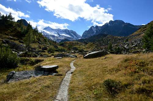
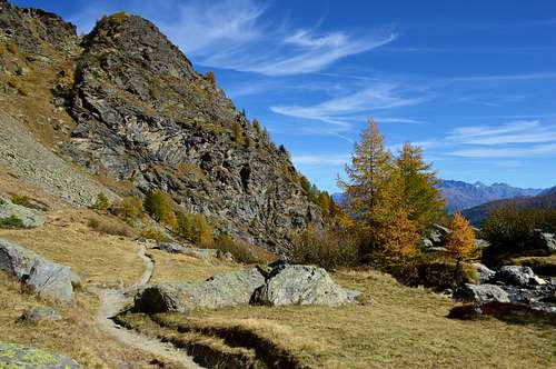
At the first bend in the shape of elbow immediately after the Village of La Clusaz to begin by the path n° 21/Alta Route n° 2 (signs), leaving on the right the road continues towards the Hamlet Baule(i)n (1.769m); proceeding with West-northwest direction with a long diagonal, followed by a series of narrow and small hairpin bends, get near the Torrent of Planaval at an altitude of about 2.150 meters. Walk along its shore hydrographic left (North), leaving on the left the Alpage of Glacier (2.162m) and on the right path n° 20b which goes to the Torre Tonda Hill. Continue in parallel with the torrent and then move away temporarily from the same, when it meets to Torrent de l'Orfeuille. Immediately after crossing it twice before returning to skirt the Northern shore with West-northwest direction first and then definitely in the Southwest towards the Baracche di Fond (2.338m) under the lake of the same name (2.438m). From below the lake of the same name (2.438 m), leaving the path n° 21 on the left for the Planaval Pass (3.016m), instead head towards the Northwest with the Alta Via path n° 2 which with two short hairpin bends leads to the Eastern shore of the Lac di Fond, sited just under the Molette's Pass. (2.774m; 2h'00/2h'30 from the hairpin band nearby the Clusaz Village; 3h'00/3h'15 from Baulen or else Baulin Hamlet).
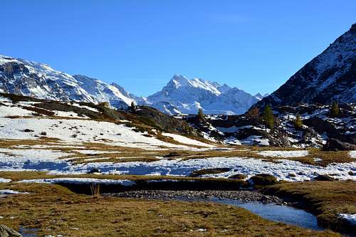
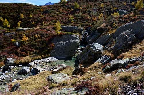
Al primo tornante a forma di gomito subito successivo all'abitato di La Clusaz incominciare con il sentiero n° 21/Alta via n° 2 (segnalazioni), lasciando sulla destra la strada che continua verso il Villaggio di Baule(i)n (1.769 m); procedendo con direzione Ovest-nordovest con un lungo diagonale, seguito da una serie di stretti e piccoli tornanti, arrivare nei pressi del Torrent di Planaval a quota 2.150 m~. Costeggiare la sua sponda idrografica sinistra (Nord), lasciando sulla sinistra l'Alpe di Glacier (2.162 m) e sulla destra il sentiero n° 20b che si dirige verso il Colle della Torre Tonda. Proseguire in parallelo con il torrente per poi allontanarsi momentaneamente dallo stesso, quando questo si riunisce al Torrent de l'Orfeuille. Subito dopo attraversarlo due volte per poi ritornare a fiancheggiare la sponda Settentrionale con direzione prima Ovest-nordovest ed in seguito decisamente a Sudovest verso le Baracche di Fond (2.338 m), sotto il Lago omonimo (2.438 m). Dal di sotto del Lago omonimo (2.438 m), abbandonando sulla sinistra il sentiero n° 21 per il Passo di Planaval (3.016 m), indirizzarsi invece verso Nordovest con il sentierino dell'Alta Via n° 2 che con due brevi tornanti conduce sulla sponda Orientale del Lac di Fond, posizionato proprio al di sotto del Colle delle Molette (2.774 m; 2h'00/2h'30 dal tornante di la Clusaz; 3h'00/3h'15 dal Villaggio di Baulen o Baulin).
Essential Gear
Hiking gear.
Da escursionismo.
 |
 |
 |
 |
 |
|---|
- REGIONE AUTONOMA VALLE D'AOSTA the official site.
- FONDAZIONE MONTAGNA SICURA Villa Cameron, località Villard de la Palud n° 1 Courmayeur (AO) Tel: 39 0165 897602 - Fax: 39 0165 897647.
- SOCIETA' DELLE GUIDE DI VALGRISENCHE
- COMPAGNIE DES GUIDES RUTOR Fraz. Entrèves tel/fax 0039.0165.885574 e-mail Guidealpine@lathuile.it
- A.I.NE.VA. (Associazione Interregionale Neve e Valanghe).
 |
 |
 |
|---|
Useful Numbers
- Protezione Civile Valdostana località Aeroporto n° 7/A Saint Christophe (Ao) Tel. 0165-238222.
- Bollettino Meteo (weather info) Tel. 0165-44113.
- Unità Operativa di Soccorso Sanitario Tel. 118.