
-
 14143 Hits
-
 83.1% Score
-
 16 Votes
|
|
Mountain/Rock |
|---|---|
|
|
34.08050°N / 116.9867°W |
|
|
San Bernardino |
|
|
Hiking |
|
|
Spring, Summer, Fall, Winter |
|
|
5795 ft / 1766 m |
|
|
Overview: West Anchor of Yucaipa Ridge
Allen Peak lies at the western end of a magnificent ridge overlooking Oak Glen to the south and with vistas of the San Bernardino crest to the north. This is the Yucaipa Ridge (a Native American name), an area not frequently visited by hikers.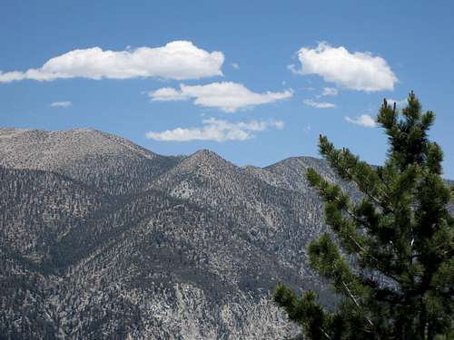
Looking towards the San Bernardino crest from Yucaipa Ridge
Traveling east from Allen Peak on the Yucaipa Ridge will take you to Birch Mountain, Cedar Mountain, Oak Glen Peak, Wilshire Peak, Wilshire Mountain and Little San Gorgonio Peak at the eastern end of this grand ridge. The peak is named after a United States Forest Service agent, although there is disagreement as to which employee named Allen it was named after.
The most direct route to Allen Peak requires that one get special permission to pass through private property, while the alternative route includes a traverse of the Yucaipa Ridge from east to west starting at Little San Gorgonio Peak.
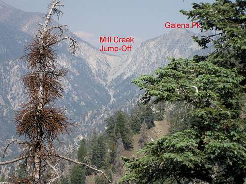
Mill Creek Jump-Off and Galena Peak from Yucaipa Ridge
This summit is a worthy goal because (1) it gets you to the Yucaipa Ridge and (2) offers superb vistas, especially of the range of peaks comprising the San Bernardino Crest.
Route Summaries
Most Direct Route
From your parking area, go south and cross Mill Creek along designated IS08. Hike up IS08 through the preserve 2.6 miles to the Yucaipa Ridge Truck Trail (IS09), at the big saddle between Allen Peak and Birch Mountain. Turn right (west) and continue along IS09 about ¼ mile where you will see on your left a north trending ridge coming down from the peak. Turn onto the ridge (south) and hike half a mile or so to the summit.

Sign at Allen-Birch Saddle
This moderate Class 2 route is about 7-8 miles with 1,300 feet of gain.
East-West Traverse of Yucaipa Ridge
This is the long but rewarding way to get to Allen Peak. From the Vivian Creek Picnic Area Trailhead head up the road along Mill Creek passing the signed turn-off going left across Mill Creek to the Vivian Creek Trail. When you reach Camp Creek intersecting your route from the south, go past it until you reach the next major gully. Begin your ascent up this gully (going south), taking the left branch where the gully forks. At about 8,100 feet elevation, go left onto a southwest trending ridge that is intermittently ducked. At about 8,480 feet, the route turns more directly south and leads to the saddle just east of Little San Gorgonio Peak (elev. 9,133’).
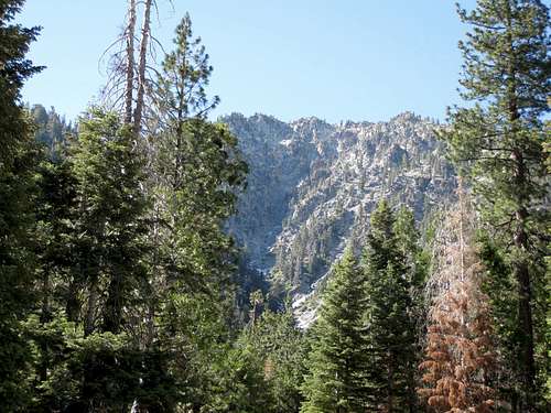
Seen from near Mill Creek, route to Yucaipa Ridge is to left side
Begin your traverse over the Yucaipa Ridge passing over Little San Gorgonio Peak, next an unnamed summit with radio towers, Wilshire Mountain (8,832’ elev. and unnamed on the 7.5 Forest Falls topo), Wilshire Peak (8,680'+), Oak Glen Peak (8,404’ and not a listed Sierra Club HPS peak), Cedar Mountain (8,324’), and Birch Mountain (7,826’). From Birch Mountain, begin a long slog, about 4 miles, to the saddle and trail junction northeast of Allen Peak. From here, proceed as described above to the summit.

Summit of Little San Gorgonio Peak (9,133')
This hike and traverse, starting at the Vivian Creek Picnic Area Trailhead and going all the way to Allen Peak, is about 14.5 miles one way. Therefore, if you opt for this route, arrange a car shuttle so that you can hike out along the Ridge Truck Trail, through the Bear Paw preserve (having gotten the requisite permission of course), and back to your car. If you do it this way, as opposed to a round-trip traverse on the Yucaipa Ridge, your total mileage will be about 18 miles with about 5,500 feet of gain.
Third Option
There is a third alternative described on the Sierra Club’s HPS Peak List for Allen Peak as Route 1, starting from the abandoned Mill Creek Campground. If you need a third option, check it out.
Getting There
Coming from the west, take Interstate 10 to the University Street exit in Redlands. Turn left onto University and proceed through the campus of the University of Redlands to Lugonia Ave./Hwy 38. Turn right at Lugonia and proceed about 14 miles through Mentone and up into the mountains to Forest Falls Road. Park at the junction of Highway 38 and Forest Falls Road, or if you have permission, inside the Bear Paw preserve.If you do the much longer alternate route hiking the Yucaipa Ridge east to west starting with Little San Gorgonio Peak, you will need to turn right onto Forest Falls Road and take it about 4.5 miles (passing through the Town of Forest Falls) to its end where you will find, on the left, trailhead parking lot for the Vivian Creek Trail.
Red Tape
There is some key red tape involved to access this peak by both of the routes mentioned. The most direct route begins in a privately owned preserve, the Bearpaw Sanctuary. You will need to contact the caretaker of that facility (it can be contacted via its Facebook page) to get advance permission to park there and to pass through the preserve toward the road to Allen Peak. You will not need an Adventure Pass to park within the preserve. Second, the Wildlands Conservancy (it has a website with contact information) owns much of the land along the route, so you must arrange for advance permission to hike from that group.Alternatively, you can make Allen Peak the last peak on a traverse of the Yucaipa Ridge from east to west. For this approach, you will start at the Vivian Creek Trailhead. You will need advance permission from the Wildlands Conservancy to do this traverse and to park at the trailhead you will need an Adventure Pass or Golden EaglePass. These passes cost $5 per day or $30 for an annual pass and can be purchased at many Forest Service locations and most major sporting good outlets.
Camping
There are no developed campsites in the vicinity of Allen Peak, but suitable spots are available all along the Yucaipa Ridge.
There are decent camping sites along the ridge
When to Climb/Mountain Conditions
You can climb year round but it goes without saying that, during winter months, you will encounter conditions requiring appropriate snow travel gear. Always have tire chains with you during winter months. Check with the California Department of Transportation (“Cal Trans”) for road conditions and with local weather services for timely forecasts.Other Information
USGS Topo :Forest Falls 7.5 QuadExternal Links
Adventure Pass informationCalifornia Dept. of Transportation
San Bernardino National Forest
Scott - Dec 23, 2014 10:22 am - Hasn't voted
Updated red tapeFrom SP member greyraven: Allen Peak, SBNF, California Hike info needs correction. There are two private property holders that affect the hike to Allen Peak. At the entry to IS08 is Bearpaw Sanctuary, which can be contacted via their Facebook page. The Wildlands Conservancy (has a website with contact info) owns most of the land on the IS08 route up to the ridge and a big portion of the land of Yucaipa Ridge Truck trail to the west. So, there are two different entities to contact doing the Hwy 38/IS08 route. However, it also means that hikers doing the transverse from the Little San Gorgonio, etc. should get the okay from Wildlands, which is currently NOT stated on the information on your website. Both groups are conservancies and generally will permit hiking groups with advance permission and signing of liability release forms.
Augie Medina - Jan 20, 2015 4:57 pm - Hasn't voted
Re: Updated red tapeThanks for sending along greyraven's information. I will make appropriate revisions to my "Red Tape" section.