
|
|
Area/Range |
|---|---|
|
|
34.10060°N / 116.828°W |
|
|
Hiking |
|
|
Spring, Summer, Fall, Winter |
|
|
11499 ft / 3505 m |
|
|
OVERVIEW
The San Bernardino National Forest is located approximately 75 miles due east of the city of Los Angeles. It contains four distinct mountain ranges and five Wilderness Areas encompassing more than 800,000 acres.* The San Bernardino Mountains include the San Gorgonio Wilderness Area (north side closed due to the Lake Fire) and a portion of the Bighorn Wilderness Area
* The San Jacinto Mountains include the San Jacinto Wilderness Area
* The Santa Rosa Mountains contain the Santa Rosa Wilderness Area
* The eastern end of the San Gabriel Mountains contain the Cucamonga Wilderness Area
Click this link for a Forest Service map of the the entire San Bernardino National Forest
This page will focus only on the San Bernardino Mountains and the eastern end of the San Gabriel Mountain Range or the mountains located North of the San Bernardino 10 Freeway. For information related to the San Jacinto and Santa Rosa Ranges please refer to the Peninsular Ranges page.
----------------------------------------------------------------------------------------------------------------------------------------------
SAN BERNARDINO MOUNTAINS
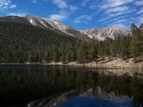
San Gorgonio and Jepson Peak viewed from Dry Lake
The San Bernardino Mountains are one of the most popular getaway destinations in Southern California with many outdoor activities including climbing, hiking, camping, skiing, boating and much more. It is roughly bordered by the Mojave or High Desert to the north, the San Gabriel Mountains to the west, Joshua Tree National Park to the east and the eastern San Gabriel Valley to the south. The crown jewel of the mountain range is San Gorgonio Wilderness Area, a large subalpine expanse. The San Bernardino Mountains are also home to several popular ski resorts located at or near Big Bear Lake. Lake Arrowhead to the west and Big Bear Lake to the east provide many sporting activities for water enthusiasts. The close proximity to Los Angeles makes the San Bernardino Mountains a favorite second home or weekend getaway destination for many in Southern California.
One can truly enjoy a wide variety of flora and fauna in the San Bernardino Mountains. Lower elevations are thick with chaparral and the eastern flanks will include Joshua trees, Junipers and Pinyon pines. Higher elevations will include several pine varieties including Jeffrey, Sugar, Ponderosa and Coulter. Amongst these you will also find some species of Oak, Fir, Cedar, Maple and Dogwood. At the highest elevations you will see Lodgepole and Limber Pines. Higher elevations will also include significant groves of Manzanita. This evergreen shrub or at times small tree has very distinctive and attractive red branching with green foliage. There is also abundant animal life as well including larger species such as Mule Deer, Big Horn Sheep, Black Bear and Mountain Lions. Don't be surprised to see flocks of Ravens circling above as you approach the highest elevations.
Note: From time to time one will notice significant dead tree stands in the Forest. The primary cause of this has been an invasion of the Bark Beetle due to the 1999-2002 drought seasons. See here for more information on the Bark Beetle.
SAN GORGONIO WILDERNESS AREA
The San Gorgonio Wilderness Area (currently closed due to the Lake Fire) encompasses over 94,000 acres and 100 miles of designated trails belonging to the San Bernardino National Forest and the Bureau of Land Management. It is located in the southeast region of the San Bernardino Mountains. The wilderness area is comprised of virgin forest land, high alpine meadows and lakes. There are ten peaks within its boundaries that are in excess of 10,000 feet or more than 3,000 meters. This includes Mount San Gorgonio, Southern California’s tallest peak at 11,499 feet.| SAN GORGONIO WILDERNESS AREA | |||
|---|---|---|---|
| MOUNT SAN GORGONIO | JEPSON PEAK | CHARLTON PEAK | GALENA PEAK |
 |  |  |  |
| At an elevation of 11,499 (3505 M) this is the highest peak in California south of the Sierra | At 11,205 (3415 M) Jepson offers some of the best snow climbs in Southern California | At 10,806 (3294 M) Charlton is one of the more popular peaks in the 9 peak traverse | At 9,324 (2842 M) Galena is the anchor peak of Yucaipa Ridge |
The Nine Peak Traverse
| SAN GORGONIO WILDERNESS AREA 9 PEAK TRAVERSE | |||
|---|---|---|---|
| (north side of the San Gorgonio Wilderness is currently closed due to the Lake Fire) The Nine Peak Traverse is a challenging and visually rewarding sub-alpine experience covering 26 miles and nearly 8,000 feet of gain/loss. All 9 summits are in excess of 10,000 feet (3,000 M+) and offer stunning views of the wilderness area. The most common approach is from the west off highway 38 at the Angelus Oaks Trailhead (elevation 5,760). After climbing nearly 5,000 feet in roughly 6 ½ miles one reaches San Bernardino Peak (10,649) the first summit. From here the traverse continues East along a tall sub-alpine ridgeline eventually climbing Southeast ultimately reaching Mount San Gorgonio. Most will make this a one way traverse choosing to descend the Vivian Creek Trail to the parking area north of Forest Falls. A pre-arranged parked car or a carpool is highly advisable. The traverse is generally completed as a multi-day backpacking trip. For the truly well conditioned this route can be accomplished in a single day. Those attempting this in a single day should already be pre-acclimatized to altitude, otherwise the result can be extremely discomforting. | |||
 9 Peak Summits Charlton Peak, Jepson Peak and Mount San Gorgonio 9 Peak Summits Charlton Peak, Jepson Peak and Mount San Gorgonio | |||
| Click on Map Icons for information about the start, the finish and each peak For another 9 peak variation check out Travis' Trip Report And For those who have unlimited endurance try Rick Kent's 17 Peak Day hike | |||
GETTING THERE
The San Bernardino Mountains have several highway access points. Depending on your destination you may have more than one route to choose from. Highway 330 /18 is the most popular way to the Big Bear Lake area. Heavy traffic and winter conditions can severely impact travel times. The San Gorgonio Wilderness area is best accessed from Highway 38. See the table below for route descriptions.Click on the corresponding road sign in the left column to get current road conditions as reported by Caltrans.
| HIGHWAY ACCESS TO THE SAN BERNARDINO MOUNTAINS | ||
|---|---|---|
| THE SAN GORGONIO WILDERNESS AREA | ||
 | Take Interstate 10 to the city of Redlands exiting Orange Street and heading north for approximately 1/2 mile. Turn right on E Lugonia Ave, Highway 38. Lugonia becomes Mentone Blvd in the City of Mentone and then Mill Creek Road and eventually State Highway 38. Approximately five miles up the road you will pass the Mill Creek Ranger Station and shortly thereafter enter the San Bernardino National Forest. From Highway 38 and the adjoining roads you can access the south, east and north sides. Highway 38 will eventually lead you to Big Bear Lake and City from the southeast side. It takes longer to arrive in the Big Bear area but is a popular alternative route during weekend and holiday traffic. | |
| BIG BEAR LAKE / RUNNING SPRINGS AREA | ||
  | Take Interstate 10 to the city of Redlands. Next take the Highland / Running Springs Highway (CA-330) exit north onto Highway 210. Follow Highway 210 for approximately 4.5 miles taking the Mountain Resorts exit onto Highway 330N. You will reach Running Springs in approximately 15 miles. Here 330 merges with and becomes highway 18. Big Bear Lake is another 17 miles further up the highway. This is the most direct and heavily traveled road to the Running Springs and Big Bear Lake areas. The road is mountainous and windy. During the winter it is susceptible to heavy snow fall and ice. At peak times heavy traffic can stretch the drive into several hours. Plan accordingly. Always carry chains. | |
| LAKE ARROWHEAD AREA | ||
| | Take Interstate 10 to the city of Redlands. Next take the Highland / Running Springs Highway (CA-330) exit north onto Highway 210. Follow Highway 210 for approximately 4.5 miles taking the Mountain Resorts exit onto Highway 330N. At approximately 14 miles or just before you reach Running Springs turn left at Live Oak Drive. Travel approximately 1.5 miles and turn left again onto Rim of the World Highway (CA-18) Travel five more miles and you will enter the Lake Arrowhead Area. Turn right on Highway 173 to Arrive at Lake Arrowhead | |
| ALTERNATIVE APPROACHES | ||
| BIG BEAR LAKE FROM THE NORTH | ||
| | From Highway 15 in Victorville exit Bear Valley Road heading east. Travel 22 miles to Lucerne Valley. Turn right onto Highway 18 and travel approximately 25 miles arriving at Big Bear Lake. This route receives less snowfall during storms and has the least amount of mountain driving. | |
| CRESTLINE FROM THE SOUTH | ||
| | From Interstate 10 in Colton proceed north on Highway 215. At approximately four miles take the Highway 210 split north. Highway 210 will soon curve and proceed east. Exit Waterman and proceed North. Waterman Avenue becomes the start of Highway 18. Continue on for 13 miles and you will arrive in Crestline. | |
| CRESTLINE / LAKE ARROWHEAD FROM CAJON PASS | ||
 | From just North of the 15 – 215 Freeway merge exit the Rim of the World Highway 138 heading east. Follow the highway approximately 20 miles into crestline and continue until you reach highway 18. Turn left and follow 18 to your destination of Lake Arrowhead, Running Springs and Big Bear Lake. | |
Caltrans Road Conditions Highway Map
CAMPING
FAMILY AND GROUP CAMPGROUNDSThe San Bernardino Mountains have 16 family and 19 group campgrounds. 11 of the family and all of the group campgrounds require reservations.
Click the below link to find information about locations, number of sites, ammenities and cost. Each campground description has a direct link to make on-line reservations.
San Bernardino Mountain Campgrounds
YELLOW POST SITES
Yellow Post Camp Sites are located within remote areas accessed on back roads or trails. No campfires or charcoal fires are currently allowed anywhere on the National Forest. Please check HERE for latest National Forest fire restrictions. Sites are available on a first- come first-served basis. Check with the local Ranger Station for Yellow Post Site locations and current fire use restrictions.
WILDERNESS CAMPSITES
Wilderness campsites are accessible by foot and /or horseback only and require a free Wilderness permit. When camping in the Wilderness, lightweight stoves are recommended. Campfires are not allowed in Wilderness Areas on the San Bernardino National Forest.
Also, due to the unsupervised nature of remote camping certain activities are often more restricted than in developed camping. Campfires, charcoal BBQs, and remote camping itself may be restricted certain times of the year due to the Fire Use Guidelines. Please call the Forest Supervisor’s Office at (909) 382-2600 for the current Fire Danger Level and current Forest Use Guidelines.
| SAN GORGONIO WILDERNESS AREA | ROAD ACCESSED CAMPSITES | ||
|---|---|---|---|
| Location | Altitude | Location | Location |
| FISH CREEK TRAIL | BARTON FLATS VICINITY | BIG BEAR LAKE | |
| Fish Creek Trail Camp | 8,600' | Barton Flats | Holcomb Valley |
| FORSEE CREEK TRAIL | Heart Bar | Pineknot | |
| John's Meadow | 7,200' | San Gorgonio | Serrano |
| Jackstraw Camp | 9,200' | South Fork | |
| Trail Fork Springs Camp | 10,400' | Wildhorse Equestrian | BIG BEAR LAKE VICINITY |
| LOST CREEK TRAIL | Coon Creek Cabin (GC) | Big Pine Flats | |
| Grinnell Ridge Camp | 8,500' | Council (GC) | Hanna Flats |
| MOMYER CREEK TRAIL | Heartbar Equestrian (GC) | Big Pine Flats Equestrian (GC) | |
| Alger Creek Camp | 7,100' | Juniper Springs (GC) | Bluff Mesa (GC) |
| Dobbs Camp | 7,200' | Lobo (GC) | Boulder (GC) |
| Saxton Camp | 8,400' | Oso (GC) | Buttercup (GC) |
| NORTH FORK, WHITEWATER RIVER | Skyline (GC) | Deer (GC) | |
| Mineshaft Flats | 9,600' | Gray’s Peak (GC) | |
| Big Tree Camp | 8,400' | RUNNING SPRINGS VICINITY | Green Spot Equestrian (GC) |
| SAN BERNARDINO PEAK DIVIDE TRAIL | Crab Flats | Ironwood (GC) | |
| Anderson Flat | 10,500' | Green Valley | Tanglewood (GC) |
| Shields Flat | 10,400' | Fisherman’s - Walk-in (GC) | |
| Dry Lake View Trail Camp | 10,540' | Shady Cove (GC) | LAKE ARROWHEAD VICINITY |
| SAN BERNARDINO PEAK TRAIL | Tent Peg (GC) | Dogwood | |
| Columbine Camp | 8,000' | Northshore | |
| Limber Pine Bench Camp | 9,200' | LYTLE CREEK VICINITY | |
| SOUTH FORK TRAIL | Applewhite | (GC) = Group Campground | |
| Dry Lake camping area | 9,000' + |  | |
| Trail Flats Camp | 9,700' | ||
| Dollar Lakes Forks Trail Camp | 9,300' | ||
| Red Rock Flat | 10,100' | ||
| High Meadow Springs | 10,400' | ||
| VIVIAN CREEK TRAIL | |||
| Vivian Creek Camp | 7,100' | ||
| Halfway Camp | 8,100' | ||
| High Creek Camp | 9,200' | ||
| SUMMIT | |||
| Summit Camp | 11,500' | ||
RED TAPE
ADVENTURE PASSParking in some trailhead and day use areas in the the San Bernardino National Forest requires an Adventure Pass An Annual Pass will cost $30.00 and a daily pass is $5.00. Passes can be purchased by mail, phone, at Ranger Stations and select local merchants. Look for the Where to Buy Passes Link. Interagency Passes (Annual, Senior, Access, Military, and Volunteer) also cover Adventure Pass fees.
SAN GORGONIO WILDERNESS AREA ACCESS PERMIT (north side of SG Wilderness currently closed due to the Lake Fire)
Entrance into the San Gorgonio Wilderness Area Requires a free permit. This applies to both single and multi-day entries. The limit is 12 people per wilderness permit. Permits can be obtained only at the Mill Creek Ranger Station, Big Bear Discovery Center and Barton Flats Visitor Center:
Mill Creek Visitor Center
34701 Mill Creek Road
Mentone, CA 92359
Phone number:(909)382-2882 Summer Hours: 8:00am to 4:30pm weekdays, 7:00 am - 3:30 pm weekends, CLOSED Tuesdays
Winter Hours: 8:00am to 4:30pm Thursday through Sunday, 8:00am to 3:00pm Monday CLOSED Tuesdays and Wednesdays
Days and Hours of operation are subject to change. It is best to call and confirm.
Big Bear Discovery Center
40971 North Shore Drive, Highway 38
Big Bear Lake, California
Mailing Address: P.O. Box 66, Fawnksin, CA 92333
Ph: 909-866-3437 (local) Ph: 909-382-2790
Fax: 909-866-1781
Hours: 8:00am to 4:30pm
CLOSED Tuesdays and Wednesdays
Days and Hours of operation are subject to change. It is best to call and confirm.
The Barton Flats Visitor Center
The Visitor Center is located approximately seven miles east of Angelus Oaks on the south side of Highway 38
It is operated May through October by volunteer staff of the San Gorgonio Wilderness Association.
Obtaining your Permit via Mail or Fax
Obtaining your permit in Person
A limited supply of self-issue permits are left out each night at the Mill Creek Ranger Station. The popular trailheads go quickly especially weekends.
CAMPFIRE PERMIT
A California Campfire Permit is required for use of a propane or gas stove, lantern or campfire outside a developed campground or developed picnic area. If you are obtaining a wilderness permit, then you do not need a campfire permit (the wilderness permit will cover your stove.) Campfire permits are available at the Big Bear Discovery Center and all National Forest Ranger Stations and must be picked up in person. Permits for campfires in remote or undeveloped areas is determined by the fire hazard conditions. Read the back of the permit and call ahead for all current restrictions.
WEATHER AND TRAFFIC CONSIDERATIONS
National Weather Service Forecast and current conditons for the San Gorgonio Wilderness Area
Big Bear Weather
The mountain climate will vary widely based on elevation. Temperatures can be as much as 30 degrees cooler in higher elevations compared to the valley floor. Heavy snow generally occurs in the high elevations during the winter months. Be aware that snow is possible any month of the year at higher elevations. Typical precipitation occurs between November and April with a dry summer season. Summer temperatures can heat up at the lower elevations and are more moderate at the higher elevations. Nighttime temperatures can be cool in the mountains, even during the summer months. Weather can change quickly, especially in the high elevations. Check weather forecasts and avoid storms.
Big Bear Lake is a very popular vacation/ski destination especially during the winter season. Chains are mandatory for all vehicles. Because the access roads to most of the Forest are winding two lane highways they are subject to severe traffic delays during winter weekends and Holidays. Allow for plenty of time to reach your destination. Be mindful that many of the weekend motorists are inexperienced snow and ice drivers.
LODGING
BIG BEAR LAKEBig Bear Lake is located in the northeastern portion of the San Bernardino Mountains. It is a very popular vacation and weekend getaway destination all year round. Lodging in the area includes cabins, condos, motels, hotels, B&B's and more. Snow season is especially popular with three major ski resorts in close proximity. Early reservations are strongly recommended:
Big Bear Lodging
LAKE ARROWHEAD
Lake Arrowhead located at the western end of the San Bernardino Mountains is also a popular getaway destination.
Lake Arrowhead Lodging
Lake Arrowhead Cabin Rentals
RUNNING SPRINGS
Running Springs is located in the center of the San Bernardino Mountains where Highway 330 and 18 intersect.
Giant Oaks Lodge
EXTERNAL LINKS
SAN GORGONIO WILDERNESS ASSOCIATION AND SAN BERNARDINO NATIONAL FOREST LINKSA great resource for trail information, current trail conditions, weather and education:
San Gorgonio Wilderness Association
San Gorgonio Wilderness Association - Backcountry Bulletin Board
Ask your San Gorgonio Wilderness questions here
U.S. Forest Service Day Hiking & Backpacking Trail Information
US Forest Service - San Bernardino Mountains Home Page
John Robinson's San Bernardino Mountain Trails - 100 hikes. A very useful resource for climbing in the San Bernardino Range - includes a map
OTHER LINKS
Big Bear Discovery Center
Peakbagger's San Bernardino Mountains
tarol - Oct 9, 2007 9:46 am - Voted 10/10
Current Fire RestrictionsUnder Yellow Post Sites you have that there are no current fire restrictions - but there are! No campfires or charcoal fires are currently allowed anywhere on the National Forest. Best to point folks towards the San Bernardino NF Website Fire Restriction Page to get the latest info.
tarol - Oct 9, 2007 9:54 am - Voted 10/10
Wilderness PermitsThe limit is 12 people per wilderness permit. Permits for the San Gorgonio Wilderness can also be obtained at the Barton Flats Visitor Center when it is open (usually on weekends in the summertime).
johnm - Oct 14, 2007 1:20 pm - Hasn't voted
Re: Wilderness PermitsTarol: Thanks for your comments. I have made the updates to the page.
tarol - Mar 17, 2010 6:30 pm - Voted 10/10
EtymologyThe name San Bernardino, given to the mountains, the National Forest, the valley, the city, and the county, originated with the last surviving member of Junipero Serra's band, Padre Dumetz. Leading a party of missionaries, soldiers, and Native Americans, Dumetz entered the valley on May 20, 1810. Since this was the feast day of St. Bernard of Sienna, he named the valley "San Bernardino" in honor of that saint.
tarol - Oct 14, 2012 2:46 pm - Voted 10/10
Better map linkhttp://www.fs.usda.gov/Internet/FSE_DOCUMENTS/stelprdb5389830.pdf
tarol - Oct 14, 2012 2:48 pm - Voted 10/10
Arrowhead Ranger Station is closed...permanently :( Big Bear Ranger Station/Discovery Center is now closed Tues/Wed year-round