Add Heading Here
Bruce and I arrived at the Mt Dana trailhead about 8:30 am on August 20. Mt Dana, the second highest peak in Yosemite at 13,057 feet, was the second of three peaks we hiked in three days in Yosemite and the White Mountains. We had done Clouds Rest the previous day and, after hiking Dana, would drive down to the White Mountains and camp overnight before hiking White Mountain Peak the next day. The Dana hike is relatively short, just three miles each way, but you gain over 3100 feet in those three miles. The good news: you don't have to give any of it back: it's all uphill going up, and all downhill coming down.
The Dana trailhead lies on the south side of Tioga Pass Road (SR 120) directly across from the Yosemite Park east entrance kiosk. The ranger at the kiosk pointed out the trail, told us we could park anywhere alongside the road, and said that, despite the rampant bear problem throughout the park, there was no need to worry about food in the car given all the traffic. Indeed, as we started out, a busy line of cars formed to enter the park on this sunny August Wednesday morning. The trailhead afforded a clear view of Dana and its peak.
![Mt Dana]() Mt Dana from trailhead
Mt Dana from trailhead
As the ranger had said, we found the trail easy to follow for the first two miles, with the first half mile passing through Dana Meadows and by a couple of inviting meadow lakes. A nice, pleasant walk ... except for the nagging feeling that, the further the nice, pleasant walk on even terrain, the less the remaining distance into which to crowd that 3100 foot elevation gain. We saw a number of deer in Dana Meadows (both going and coming) and lingering remnants of the July wildflowers along the trail.
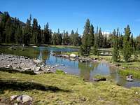
![Meadow Lake]() Meadow Lake
Meadow Lake![Meadow Lake]() Meadow Lake
Meadow Lake
After half a mile, the trail turned upwards, and began a moderate uphill climb. We're both from the Washington, D.C. area, that is, not much above sea level. Although we had spent the previous day hiking Clouds Rest, it didn't take long to notice that the air at 10,000+ feet contains somewhat less oxygen than either of us was used to.
![Trail Begins to Climb]() Trail Turns Up
Trail Turns Up
After about a mile on the trail, we emerged above the tree line and could look back down on Tioga Pass Road, the kiosk and trailhead. We began working up a steeper talus slope, staying with the still clearly marked trail, now a combination of sand and rock, as it switched back and forth up the hill. This provided a good foretaste of the last, rocky mile up Dana.
![On the First Talus Slope]() Up the Talus Slope
Up the Talus Slope![Treeline]() Passing the Treeline
Passing the Treeline
After about two miles and 1500 feet elevation gain, we came to a plateau, with the Dana summit directly in front of us. To the west, we had a great view of Tuolumne Meadows and the Yosemite peaks separating Dana from the Valley. Following a food break, we set off again, crossing the plateau in short order. Then the fun began, as the trail worked its way up the slope, gaining 1500 feet over the last mile. Actually, there's more than one trail at this point -- several parallel one other. Route-finding at times was difficult, and we often found ourselves off trail, scrambling across rocks, only to stumble back on to it (or onto one of the parallel routes). Previous climbers had helpfully placed small rock cairns to mark the trails, but picking them out against all the other rocks often presented a challenge, at least for our middle-aged eyes. The trail that we took to the summit stayed close to the east ridge all the way to the top. Coming down, we used a trail that started on the west side of the summit. It quickly curved to the north and down, running 75-100 yards to the west of the trail we had taken up. The western trail was much easier than the one we had taken to the summit. Back on the southern end of the plateau, we found where the trails separated: the left fork (heading toward the east ridge) looks like the more heavily used, so we had followed it up. But the right fork presented the better trail and, once on the slope, the trail that was easier to follow.
![Mt Dana]() Plateau and Summit
Plateau and Summit![Starting the Last Segment]() Up the Last Segment
Up the Last Segment![Tuolumne Meadows]() Tuolumne Meadows
Tuolumne MeadowsAs we hiked and scrambled toward the summit, our lungs began to really feel the altitude. Lots of water and pacing helped. The picture below, taken at about 12,800 feet, shows the incline and rocks typical of the final slope. I packed away my trekking poles, which too often got tangled among the rocks. One couple coming down offered encouragement. Ten minutes later, I encountered three others coming down. Me: "How far to the summit?" Them: "You're getting close." Me: "Define 'close'." Them: "One minute." Me: "Right answer!"
![Final Slope]() Final Slope
Final Slope
Ninety seconds later, the summit, which afforded spectacular views in all directions. Below, the summit marker and Mono Lake, 9000 feet below and to the east.
![Summit Marker]() Summit Marker
Summit Marker![Mono Lake]() Mono Lake
Mono Lake
Mt Conness lies directly to the north, and Mt Lyell (the highest in Yosemite) and its glacier tower to the southwest.
![Mt Conness]() Mt Conness
Mt Conness![Mt Lyell]() Mt Lyell
Mt Lyell
After signing the summit log (located in an ammo box right next to the USGS marker) and soaking in the views, it was time to head down. As noted, the trail down to the plateau was considerably easier than the one coming up. Then down the main trail to the car, the drive to Grandview Campground in the White Mountains with a quick dinner stop in Bishop, and to sleep to get ready for the next day's hike to the top of White Mountain Peak. All in all, a day well-spent.
Comments
No comments posted yet.