

|
|
Mountain/Rock |
|---|---|
|
|
56.75898°N / 4.96659°W |
|
|
Hiking, Mountaineering, Ice Climbing, Scrambling, Skiing |
|
|
Spring, Summer, Fall, Winter |
|
|
3222 ft / 982 m |
|
|
Overview
 An Gearanach above Steall waterfall
An Gearanach is located within the picturesque Mamores Range. The Mamores Range is basically a 15km ridge that separates the wondrous beauty of Glen Nevis in the north from the flowing waves of Loch Leven in the south.
An Gearanach (translation: The Complainer) stands at a height of 982m/3222ft, is classified as a Munro and is number 166 in the Munro heights table. This peak and its neighbour An Garbhanach (translation; The Rough Ridge) provide an excellent high level ridge walk that narrows to an arête that requires great care in icy conditions.
An Gearanach can be climbed from the south via Coire Na Ba, but undoubtedly the best route of ascent is to approach via Glen Nevis in the north. This approach walk through the Nevis gorge is simply delightful and the area was described by W. H. Murray as one of ‘Himalayan character’. In 1961 a proposed Hydro-Electric scheme collapsed at a public enquiry and if it had not been for the effort of the people that opposed such a barbaric idea, then a truly wondrous piece of the Scottish landscape would have been lost forever.

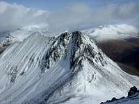 An Garbhanach
The approach walk from Polldubh along to Glen Nevis follows the northern slopes of the gorge, displaying beautiful woodland of Scots Pine, Oak and Birch. The path is a good one and is well frequented in the summer months, although it should be noted that great care should be taken as there is a huge drop down to the floor of the gorge and fatalities have been known to happen. The powerful torrent of the Water of Nevis can be heard for the entire walk through the gorge and its erosive power is no better displayed than by the array of strangely shaped rocks that litter the entire length of the gorge. The 0.5 mile walk through the gorge culminates when the path opens out onto the lush meadows of Glen Nevis itself. From here An Gearanach is clearly seen towering above the 300ft high Steall Waterfall which is one of the finest waterfalls in Scotland. Fed by the Allt Coire a'Mhail (translation: River of the Corrie of the Rent), which comes from the surrounding peaks that are commonly known as The Ring of Steall, it creates the third highest waterfall in Scotland and makes for a most scenic end to the beginning of your climb.
After a prolonged cold spell the waterfall has been known to freeze producing an impressive wall of ice, and upon it a fine Scottish Grade III route (120m). According to Simon Richardson's 'Ben Nevis: Rock and Ice Climbs', despite it's intimidating appearance the route, if climbed by the line of least resistance, is considerably easier than it looks. The best descent is to abseil down through the trees on the east side.
Getting There

CAR
From Glasgow take the A82 road via Loch Lomond northbound direct to Fort William.
Fort William can also be accessed from Stirling, Perth or Edinburgh by joining the A85 road and following this until joining the A82 northbound.
RAIL
From Glasgow Queen Street station take the West Highland Railway line direct to Fort William. Train timetables are available here
BUS
A bus service runs daily from Buchanan Street bus station in Glasgow to Fort William and then to the Isle of Skye. A full timetable is available here
From Fort William you will need to make your way to Polldubh to the east past Ben Nevis. This can be done by car or on foot and from there, then make your way through the Nevis gorge until reaching Glen Nevis.
Route
 Steall Waterfall
 The wire bridge
 Ben Nevis from the shoulder of An Gearanach
 Sgurr a'Mhaim from AnGearanach

The start of the route is arguably the most exciting part of the day. Having already reached the meadows of Glen Nevis it’s time to cross the Water of Nevis by way of the wire bridge located in front of Steall waterfall. The wire bridge is made up of three wires, one for your feet and two for your hands. It is roughly 10ft above the Water of Nevis and roughly 20ft in length and it gets pretty wobbly in the centre. With the water flowing beneath you and possibly a small crowd of tourists watching, the pressure is definitely on for you not to fall off.
Once across, ford the stream that flows from the waterfall and head east through boggy ground or skirt the banks of the river (less boggy) until reaching a path that leads southwards up the left hand side of a burn. There is evidence of recent landslide alongside the path and there are certain points of the path that look on the verge of collapsing away, so care should be exercised. Follow the path up the glen where it zigzags gradually up the centre of the corrie until the final zigzag leads onto the north-west shoulder of the peak. The full grandeur of the horse shoe shape created by the peaks of An Gearanach, Stob Coire a’Chairn, Am Bodach, Sgurr an Iubhair and Sgurr a’Mhaim unfolds before you, with all their slopes dropping gracefully into the corrie where the Allt Coire a’Mhail forms and flows towards the waterfall. Follow the well defined path the remainder of the way until reaching the summit cairn, with views of the remainder of the Mamores peaks, Glencoe to the south and Ben Nevis and the Grey Corries to the north.
If continuing onwards to complete the Ring of Steall, head south along the ridge to An Garbhanach, or if your day is done then descend via the route just taken in ascent. Once back in Glen Nevis, if you want to just wade through the Water of Nevis (if possible) as the legs might not be quite sturdy enough to handle another shot at the wire bridge. I done this as I felt a bit tired and didn’t really fancy walking back to the car wet or giving the tourists something to laugh at!
Red Tape
There is no red tape in Scotland due to the Land Reform (Scotland) Act 2003 which incorporated the Scottish Outdoor Access Code. This code, which commenced on the 9th of February 2005, has established statutory rights of access to land and inland water for outdoor recreation.The Land Reform(Scotland) Act 2003
Scottish Outdoor Access Code
The following aspects should be taken into consideration when you are in the Scottish countryside;
- Seek local advice in regard to deer stalking or grouse shooting activities
- Ensure that all gates are closed behind you
- During the lambing season (March to May) ensure that all dogs are kept on a lead
- Please refrain from feeding or annoying any animals
- Limited parking space is available at the start of many routes, please ensure that you are not blocking a road and/or entrance
- Parking is provided at the start of some routes by the local farmers, it is polite to ask if you can use this facility
- Try to refrain from crossing fields with animals and/or crops if an alternative route is available
- Ensure that you treat the local environment with care by leaving it as you found it and by taking any litter home with you
- Any camp fires should be carefully watched and only used away from dense forest areas
- Natural waste should be done in a hole and then buried when wild camping
Accommodation

There are numerous Hotels, B & B’s and campsites in Fort William.
A selection of Hotels in the Lochaber area can be found here.
A selection of B & B‘s can be found here.
There are the following campsites/holiday parks.
Lochay Holiday Park
Linnhe Lochside Holidays
Glen Nevis Holidays
Wild camping is permitted in the area with Glen Nevis itself being an ideal spot, although the midges can be pretty brutal here.
Books and Maps
 Extract form the Ordnance Survey 1:50k map of An Gearanach
Books
The Central Highlands by Peter Hodgkiss
Scottish Hill and Mountain Names by Peter Drummond
The Munros by Cameron McNeish
The Munro Almanac by Cameron McNeish
More Wilderness Walks by Cameron McNeish
Scottish Mountains on Ski by Malcolm Slesser
50 Best Routes on Scottish Mountains bt Ralph Storer
Ben Nevis and Glen Coe: 100 Walks in Lochaber by Ronald Turnbull
Scrambles in Lochaber by Noel Williams
Maps
Harvey Superwalker Map: Ben Nevis
OS Explorer Map sheet : 392 Ben Nevis & Fort William
OS Landranger Map sheet 41: Fort William & Glencoe
OS 1:25 000 scale sheet 94: Glen Coe, Rannoch Moor & Crianlarich
Weather Conditions
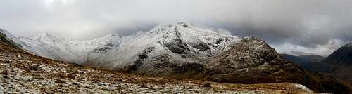 Mamores panorama from An Gearanach
The weather conditions in Lochaber can alter rapidly and you should ensure you are fully prepared for all weather eventualities. If you experience a sudden deterioration in the weather conditions and you have any doubts about continuing then please, just turn back.
Mountain forecast
Avalanche forecast
General weather forecast
External Links
GeneralScottish Mountaineering Club - Scotland's national mountaineering club
The Mountaineering Council of Scotland - Scotland's official mountaineering body
British Mountaineering Council - Britain's official mountaineering body
Climbers Club - British national climbing club
Lochaber Mountain Rescue Team - Information about the Lochaber Mountain Rescue Team
www.mrcofs.org - Mountain Rescue Committee of Scotland
Scottish Ski Club - home page of the Scottish Ski Club
Nevis Range - ski centre information for the Lochaber area
Visit Scotland - website for the Scottish Tourist Board
Visit Fort William - tourist information for Ben Nevis and the surrounding area
Munro Magic - informtion of the Munros
The Highland Council - local authority home page
Scottish Natural Heritage - Scotland's statutory body for the protection of landscapes
Joint Nature Conservation Committee - Britain's statutory body for the protection of wildlife
Nevis Sport - a major outdoor shop and mountain centre in Fort William
Discover Scotland - Scottish tourist information
Undiscovered Scotland - more Scottish tourist information
The West Highland Way - Web page fo the West Highland Way
Walk the Highlands - Scottish Walking resource
Buachaille.com
Mountain Conditions
West Coast Mountain Guides - Avalanche information, climbing conditions and weather forecasts.
Abacus Mountaineering - Climbing conditions
The Scottish Avalanche Information Service (SAIS) - Avalanche information
Weather
Mountain Weather Information Servise (MWIS) - mountain weather forecast
Metcheck - 7 day weather forecast
Met Office - Weather from the Met Office
Weather Channel UK - Weather Channel weather
Travel
Lochaber Transport Forum - local public transport information
National Rail - UK Train Timetable
Showbus - bus timetables for the UK
Citylink - Scottish bus timetables
Inverness Airport - home page of Inverness airport
BAA Glasgow Airport - homepage of Glasgow airport
Glasgow Prestwick Airport - home page of Glasgow Prestwick Airport
BAA Edinburgh Airport - home page of Edinburgh Airport
Caledonian MacBrayne Ferries - ferry information and timetables for the wet of Scotland
ecossenet: Taxis - list of taxi companies operating in the Fort William area
Accomodation
Visit Scotland: Fort William - an extensive list of accomodation in and around Fort William
The Mountain Bothies Association - information on bothies (mountain huts) in Scotland
Scottish Youth Hostel Association - home page of the SYHA
Glen Nevis Youth Hostel - page of the Glen Nevis YHA
Scottish Independant Hostels - a directory of independant hostels in Scotland
UK Campsite.co.uk - directory of campsites in the Fort William area
Maps and Guidebooks
Ordnance Survey - Britain's national mapping agency
Harvey Map Services - an excellent selection of maps designed specifically for outdoor enthusiasts
Cicerone Guidebooks - guidebooks for people of all abilities
Climbers Club Guidebooks - guidebooks for climbers
Scottish Mountaineering Club - guidebooks and publications for and about Scottish mountains
Ken A - Nov 13, 2015 8:13 am - Hasn't voted
Updated infoHi, Under 'External Links' and 'Mountain Conditions' could you please update the URL for West Coast Mountain Guides to: http://www.westcoast-mountainguides.co.uk/category/news/ Much appreciated! Ken Applegate