
-
 17808 Hits
-
 91.45% Score
-
 35 Votes
|
|
Area/Range |
|---|---|
|
|
56.75395°N / 4.92582°W |
|
|
Hiking, Mountaineering, Ice Climbing, Scrambling |
|
|
Spring, Summer, Fall, Winter |
|
|
3706 ft / 1130 m |
|
|
WHY THE MAMORES?
This is why: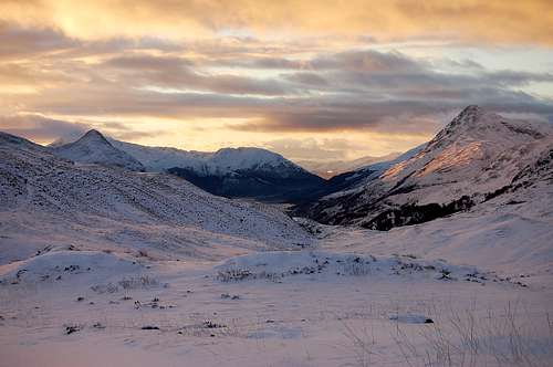
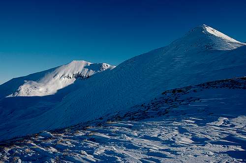
Towards Kinlochleven and Loch Leven on southern side of the Mamore range December 2010.
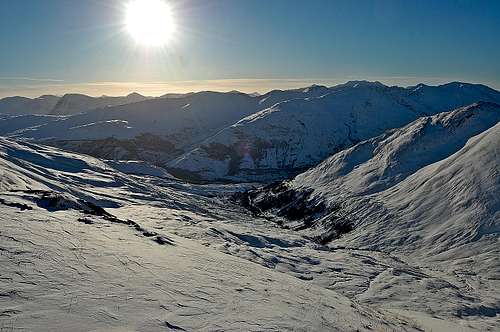
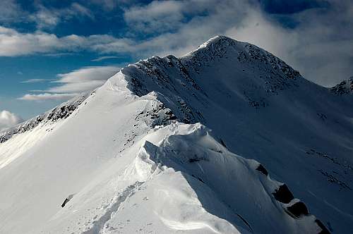
In the Mamores looking towards Kinlochleven December 2010
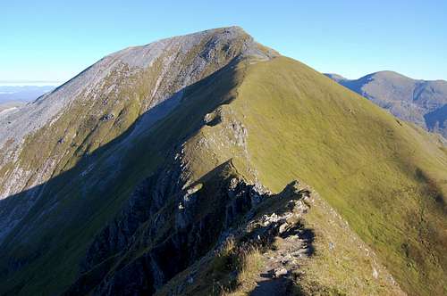
Sgurr a' Mhaim 'Devils Ridge' in September 2010
OVERVIEW
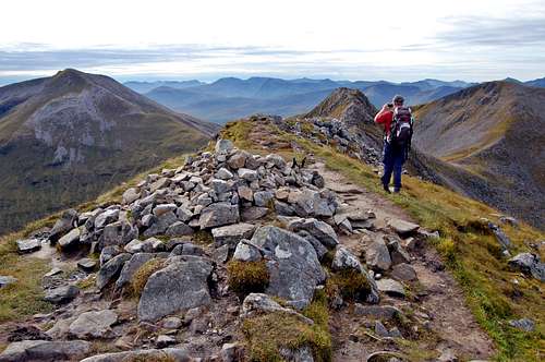
A Munroist on the summit of An Gearanach, September 2010.
Dwarfed by mighty Ben Nevis to the north and surpassed in ruggedness by the peaks of Glencoe to the south, the Mamore range is easily overlooked. I nearly overlooked them myself: in September 2010 I intended merely to cross the range, as I walked from Ben Nevis to Glencoe. But then, in the depths of Glen Nevis, I suffered the worst midge attack I’ve ever experienced (see TR Sept 2010 ).
The massed winged assailants sent me fleeing for the heights, which just happened to be those of An Gearanach, first summit of the legendary Ring of Steall - and one of the main Mamore peaks. Still itching, but no longer being bitten, I continued south along an attractive ridge to join the main east-west spine of the range on the top of Stob Coire a’ Chairn. At this point my plan was to descend to Kinlochleven before following the West Highland Way to Glencoe – and more potentially midgey camping. I was loath to descend. Inspired by a succession of fanatical Munro-baggers, I became resolved to stay with the Mamores – and stay high. Before two more days had passed I had bagged another eight Mamore summits heading east, camped by a glorious (& relatively midge-free) high mountain lochan – and I had fallen in love...
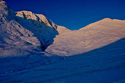
I fell in love to the extent that three months later, during the coldest December week for 80 years, I returned(see TR Dec 2010 ).
It was even better. The range was transformed into a winter wonderland, straight out of some fairy story. For three glorious days I floundered through snow drifts, picked my way along airy ridges of whipped meringue – bathed in light that was golden when it wasn’t pink. I didn’t see a soul – or even so much as a single midge either. Crampon footed and moving much more slowly than in the summer I traversed just three more Mamore’s, towards the eastern end of the range and had two nights out at high camps with temperatures down in the minus twenties. My combined excursions have left me with the three most easterly Mamore ‘Munro’s’ still do – plus a couple of obscure tops...
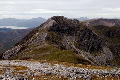
Na Gruachaichean from the east.
Na Gruachaichean from the west.
The Mamore range includes ten ‘Munro’s’(peaks of over 3000ft, famously tabulated by the late Sir Hugh Munro) and as I discovered, provides worthy sport in both summer and winter. There are also another seven significant ‘tops’ of around 3000ft, which as subsidiary peaks don’t make it onto the famous tables. Overall there are 17 summits and tops of 2700-3706ft.
The main spine of the Mamore range is composed of a west-east ridge approximately 15km long. Half of the ten Munro’s form the main vertebrae of the spine. Of the other half, three are at the end of north pointing spurs – and are easily accessed from Glen Nevis. The remotest pair of the ten is relatively isolated at the eastern extremity of the range, standing a little apart from the main ridge.
PRINCIPLE SUMMITS
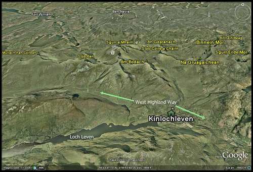
Google earth image: Mamore range from the south.
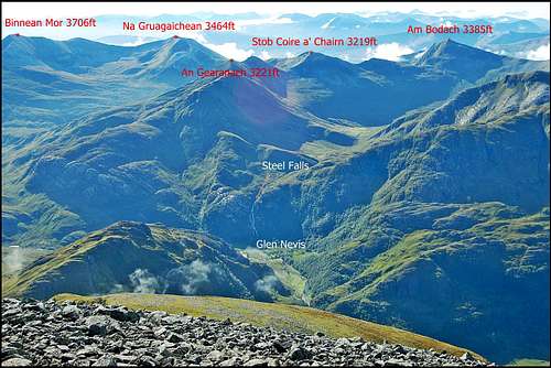
Central and eastern Mamore’s.
The most western Mamores.
Sgurr Eilde Mor 1010m 3313ft: most eastern Munro and also relatively isolated.
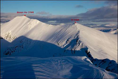
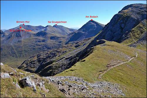
Binnein Mor 1130m 3706ft – highest of the range, just north of the far eastern end of the main spine.
Na Gruagaichean 1056m 3464ft: which dominates the Kinlochleven skyline, towards the eastern end of the range.
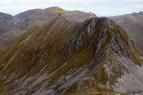
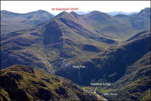
An Gearanach 982m 3221ft: on spur extending north from spine, at end of the eastern arm of the ‘Ring of Steall’.
Stob Coire a’ Chairn 981m 3219ft: on the eastern arm of the ‘Ring of Steall’ horseshoe.
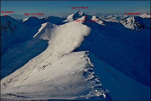
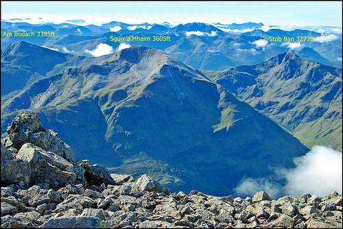
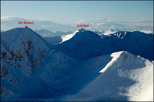
Am Bodach 1032m 3385ft: At the apex of the ‘Ring of Steall’ horseshoe, on the main spine.
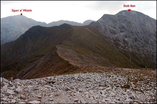
Sgurr a’Mhaim 1099m 3605ft: highest of the ‘Ring of Steall’, with spectacular the ‘Devils Ridge’ between summit and main spine of the range.
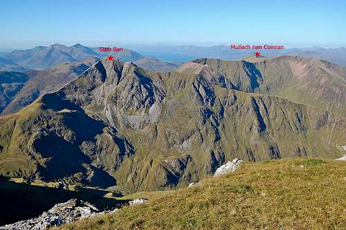
Stob Ban 999m 3277ft: a picturesque rocky summit on main spine west of ‘Ring of Steall’. The summit area is composed of attractive white quartz-like minerals – in marked contrast to adjacent ridge.
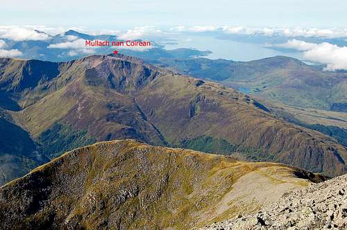
Mullach nan Coirean 939m 3080ft: most western Munro of the range – a rounded grassy mountain whose gentle western slopes terminate at the West Highland Way.
LESSER SUMMITS
The following are also significant summits, which are either less than 3000ft high or over 3000ft, but not of sufficient prominence to be described as Munro’s:Meall a Chacrainn910m 2985ft: the most western Mamore. Not quite a Munro.
Pt 917m 3008ft: an un-named top on the main spine between Stob Ban in the east and Mullach nan Coirean in the west.
Sgurr an Lubhair1001m 3283ft: on the spine at a junction of four ridges between Stob Ban, Sgurr a’ Mhaim, Am Bodach and Stob Coire na Eirghe.
Stob Coire na Eirghe826m 2710ft: on fourth ridge extending south of the spine from Sgurr an Lubhair.
An Garbanach975m 3198ft: on the north pointing spur between Stob Coire a’ Chairn and An Gearanach.
Pt 1062m 3483ft: an elegant but unnamed summit on spine at the junction of ridges from Na Gruagaichean and Binnein Mor. It comes somewhere in between being a summit in its own right and being a subsidiary summit of Binnein Mor.
Sgor Eilde Beag 956m 3136ft: most eastern point of main Mamore spine – at the end of a spur pointing south-east – and main access point from or descent to Loch Eilde Mor.
Pt 1062m 3483ft: The elegant but unnamed summit between Na Gruagaichean and Binnein Mor.
Sgor Eilde Beag 956m 3136ft: most eastern point of main Mamore spine.
THE RING OF STEALL

Google Earth image Ring of Steall.
Sgurr a’ Mhaim at end of Ring of Steall, laborious ascent route RH steep ridge.
The route up An Gearanach from upper Glen Nevis
In the case of An Gearanach, the path starts in upper Glen Nevis a few hundred metres to the east of the Steall Hut and the spectacular 100m high Steall water-fall. To reach this point it is necessary to walk half an hour beyond the final car park of lower Glen Nevis, up through a gorge and then across the river Nevis via a wire Nepalese bridge.
The start for the ascent of Sgurr a’Mhaim is at Achriabhach in lower Glen Nevis – where there is a little car park close to where the road crosses the river Nevis – and on the opposite side of the valley to the Polldubh crags. Note that this is a very long laborious ascent starting nearly at sea level and finishing at 3605ft. The ascent of An Gearanach, at the other end of the horseshoe is also laborious, but since the steeper parts start a few hundred feet higher and finish 400 feet lower, there is something to be said for doing the round clockwise – starting with An Gearanach and finishing with a long descent from Sgurr a’Mhaim.
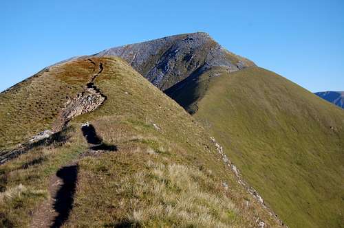
Most of the Ring of Steall circuit is completely straight forward. There are just two sections where the ridge is narrow and mildly exposed: heading south from An Gearanach towards Stob Coire a’ Chairn, on the mid section descending from the ‘top’ of An Garbanach; the other section is the ‘Devils Ridge’ ascending north towards the summit of Sgurr a’Mhaim – where there is also a little scrambling.
In terms of timing The Ring of Steall is straight forward to manage in a day in summer with long daylight hours and in favourable weather – and with a reasonable level of fitness. For a hardened Munroist, it could be half a day’s mild workout, before plunging off up another ridge to knock off a few more... In winter it would be another matter – even for a fanatic Munroist – with much shortened hours of daylight and added complications of snow, ice – or that famous Scottish speciality: horizontal freezing rain.
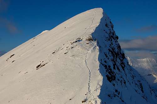
At the start of Devils Ridge, looking up at Sgurr a' Mhaim.
At the start of Devils Ridge, looking across Ring of Steall to the eastern peaks.
OTHER MAMORE EXCURSIONS
The entire range can (so it is said) be traversed in a single day – in summer and with favourable weather. On my travels in September 2010 I did encounter a fanatic Munroist who alleged he was doing this, fuelling himself with just a half a pint of bog water and a hand-full of trail-mix every 2-3 summits. But for normal mortals a two or even three day trip is appropriate – overnighting at high camps or bivvies.All sorts of permutations are possible, depending on levels of fitness, fanaticism, season – and the all important weather conditions.
It is worth re-iterating that even in summer, weather conditions can become quite severe – and safe navigation can require experience and skill. In winter it can be positively arctic, with a mere 7 hours of usable day-light in December (and a very, very long night for camping out...). Reasonable distances to travel must be correspondingly much shorter in winter compared to summer – and mountaincraft skills correspondingly higher still – including experience in the use of crampons and ice-axe.
In terms of accessing the Mamore range: the western and middle section (including western arm of The Ring of Steall) can most easily be accessed from lower Glen Nevis and the West Highland Way. The middle section at Stob Corrie a’ Chairn and Na Gruagaichean can be accessed via a side valley leading up from Kinlochleven. The very eastern most Mamore’s can be reached from either upper Glen Nevis – or from the shores of Loch Eilde Mor, several kilometres to the east of Kinlochleven.
Am Bodach & Stob Ban from east.
Stob Ban & Sgurr a’ Mhaim from the west.
GETTING THERE

Airports
The 3 city airports of Glasgow, Edinburgh and Inverness are all within an approximately 100 mile radius of the area. Glasgow is the closest and most convenient of the three at less than 70 miles.Road
The A82 runs from Glasgow to Inverness via Fort William and is the main access to the Mamore area. Traffic from Edinburgh would follow the A85, joining the A82 at Crianlarich and then continuing north. Traffic from Inverness would follow the A82 south and through Fort William.Note that those travelling up on the A82 from the south all pass through Crianlarich and on to Tyndrum, from where the road climbs up to around 1400ft as it crosses Rannoch Moor, before descending to Glencoe. This is a very exposed as well as high stretch of road. In summer this isn’t a problem. But in winter the road may be closed by snow periodically – albeit not usually for much longer than a few hours, since the authorities are normally fairly swift to bring in snow-ploughs. It is worth checking traffic news (via AA or RAC) if snow is forecast.
To access the Mamore range from the north, leave Fort William on Belford Road, heading south-east into upper Glen Nevis and running alongside the river Nevis. Approximately a mile down this narrow road are in quick succession the main car park for Ben Nevis tourist path and access to the West Highland Way – and a little further on a visitor centre and main camp site – and a Youth Hostel. The road continues another 2-3 miles to the road head and car park for upper Glen Nevis walks.
Note: parking is not permitted overnight at the main Ben Nevis tourist path car park. A vehicle may however be left at the main campsite for a small fee (+ can leave route details etc).
To access the Mamore range from the south, it is necessary to travel to Kinlochleven. From Fort William travel south on the A82 – to cross Loch Leven via the Ballachulish Bridge, and on the village of Glencoe. Travellers from the far south would need to reach the same place. From Glencoe Village the B863 runs along the Loch side to reach Kinlochleven after about seven miles (about 20 miles from Fort William).
Here’s a link to the RAC Route Planner
Rail
Fort William is the main railway hub in the region. Please click on link to ScotrailBus
For regional buses: Scottish City linkFor local buses: Fort William buses
CAMPING/ACCOMODATION
There are good campsites at both Kinlochleven and in Glen Nevis. See links below:Glen Nevis camping
Kinlochleven camping
There is a Youth Hostel in Glen Nevis: SYHA
There are numerous guest houses and hotels in the region, but I will give one place in Kinlochleven particular mention, having enjoyed a warm welcome there in December 2010. This is the MacDonald Hotel, situated conveniently close to the access for both the West Highland Way and the southern Mamores. The Hotel is open throughout the year, but may be busy in the summer – when there are cabins and camping facilities open in addition. Please click on link: MacDonald Hotel
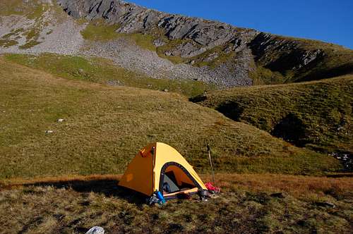
Camping in the mountains
Camping is permitted in the mountains. At valley level it is possible to camp anywhere in upper Glen Nevis, which appears idyllic in the summer – until the midges come out! (see TR “Of Vampires, Men & Mountains etc...”).Up above valley level camping is (as usual) determined by the availability of shelter, horizontal pitch and water. Numerous places are possible. I found a couple of particularly good camping places along the main ridge:
One of the sites is at a level plateau overlooking Loch Eilde Mor at around 2700ft – just a couple of hundred feet below and to the south of the lowest point of the main ridge between Na Gruagaichean and Pt 1062m/Binnein Mor – and convenient for the eastern Mamore’s. OS Grid Reference is 218652.
The other site and convenient site for the western Mamore’s is beside a tiny lochan at around 2500ft to the north of the main ridge just to the west of Sgurr an Lubhair – and in-sight of both Sgurr a’ Mhaim and Stob Ban. OS Grid Reference 160654. The main view from this site is looking towards Glen Nevis.
The two sites I found are strategically placed for a full traverse of the Mamore range from north to south or vice versa.
Convenient site for the western Mamore’s near tiny lochan to the west of Sgurr an Lubhair at OS Grid Reference 160654.
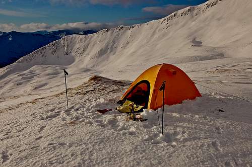
Camp below lowest point of the ridge between Na Gruagaichean and Pt 1062m/Binnein Mor at OS Grid Reference 218652.
RED TAPE
There is no red-tape involved with climbing/walking in the Scottish Highlands. There are rights of access for outdoor recreation pretty much everywhere. BUT – naturally common sense must be applied in terms of following an acceptable country code – avoiding pollution of any kind, burying bodily waste away from water sources but packing out all litter; close gates you have opened; don’t disturb any wild-life or farm animals... particular care at lambing season March-May. Seek local advice regarding any restrictions to do with deer-stalking/grouse shooting.Safety
Whilst permits etc are not required to visit the mountains, it is sensible practice to leave a route card with a local agency – be it camp-site, visitor centre, hotel. The mountains in the Scottish Highlands are not big by alpine standards but nonetheless have caught out Himalayan veterans especially in winter. It is important to check weather conditions and to seek local advice on conditions – especially in winter, when there can be substantial avalanche risk.The Lochaber and Glencoe mountain rescue teams cover the Mamore area. These are largely voluntary/charitable organisations which carry out admirable work in any season. Mountain rescue can be accessed by dialling either 999 or 112.
Note: 112 is the Europe-wide emergency number. There are some advantages in calling this number in an emergency, especially from a mobile phone. Note also: reception is patchy but not impossible over much of the Mamore range – but if you dial 112, it can ‘break in’ to which ever network is operating best in the area – and may generate information as to your approximate whereabouts (if you don’t know yourself!).
TAKE ONLY PICTURES - LEAVE ONLY FOOT-PRINTS...
MORE LINKS
ICE FACTORBEN NEVIS VISITOR CENTRE
KINLOCHLEVEN VISITOR CENTRE
BEN NEVIS WEATHER
REGIONAL WEATHER
SCOTTISH AVALANCHE INFORMATION SERVICE
WEST HIGHLAND WAY
ORDINANCE SURVEY MAP OF AREA