Back again
On Sept 18th of 2005, Dennis Poulin and I had made the trip to the Wallowas to climb East Peak, Hidden Peak and Aneroid Mountain. Aneroid was the one we wanted the most but I was recovering from an accident I suffered in Utah two weeks earlier and just didn't have it to go from Hidden Peak to Aneroid so I watched Dennis as he made his way down from Hidden and then up to Aneroid. I sat on the summit of Hidden and watched him for an hour before I made my way back towards the tram. Dennis wrote this fine
TRIP REPORT on that effort and I refer you to it. While sitting on the summit of Hidden, I vowed that I would return and finish what we had started and that opportunity came on July 14th of 2006 when my wife expressed an interest in seeing the Wallowa Lake area. One of the reasons for wanting to do Aneroid came from the fact that it was one of
Oregon's prominence peaks coming in at #61 on Greg Slayden's fine list.
Aneroid also comes in at #9 on the
Mazama's 100 highest list. Thus it is a desirable mountain to peakbag for those of us who are motivated by such things as lists.
We made the trip from Kennewick on thursday evening and found a camping spot at the zoo they refer to as Wallowa State Park. Not my idea of camping but it sufficed for the night. We actually paid for two nights as we thought we might spend some time in the area on Saturday after I climbed Aneroid but as will unfold, you will see that one night was enough.
Friday morning of the 14th we had a leisurely time since my plan was to take the Mt. Howard tram up. Originally the goal was to go via the tram both ways but in case I found the going slow and not being able to make it back to the tram before they shut down, I also had a backup of traversing the peak and coming back via the trail near the saddle that drops down to Bonny Lakes. It turned out to be a traverse.
The first leg via the tram
The Mount Howard Tramway rises up from near Wallowa Lake State Park and offers a fine way to begin the hike
at 8050 feet instead of 4650 at the trailhead, a savings of 3400 feet and at least three miles of the trail that led up to Aneroid Lake and beyond. We arrived at the tram in time to be some of the first to ride the tram up (my wife was able to ride up and enjoy the view)to Mt. Howard and by 10:30, I was heading for the trail that led up toward East Peak. I made my way to the east side of East Peak, having no desire to go over the top of the peak again as we had done back in September. The sidehill trip was looking good until the trail disappeared and I had to slowly work my way over
to the saddle between East Peak and Hidden. Rather than go over the top of Hidden Peak again, I worked my way around the west side of Hidden Peak and
found the ridge that would allow me to get up Aneroid Mountain.
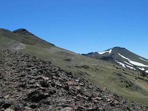
![West side of Hidden Peak]() West side of Hidden Peak with Aneroid in the distance
West side of Hidden Peak with Aneroid in the distance
This plan worked well and once I got on the ridge that connected Hidden Peak to Aneroid, it was a straightforward effort that led me to the summit of Aneroid. It got a lot steeper than the pics show but nothing beyond class 2. The summit was easily located and contained an ammo can register with very damp logs inside. Carefully signing the wet page, I sat down and began to enjoy the tremendous views. The Wallowa mountain range was laid out before with views down to Aneroid, Dollar and Bonny Lakes. Cusick, Pyramid, Petes Point, Eagle Cap, Matterhorn, Huryal Ridge, Chief Joseph and other peaks too numerous to mention here were gorgeous with the remaining snow that some of them had. Looking to the east I could see the Seven Devils area beyond Hells Canyon and deep into Idaho. Perfect conditions with just a bit of wind to help keep the bugs away. I took the opportunity to take off my boots and change socks but before I knew it I had lingered too long and I doubted I would make it back to the tram in time.
The traverse
![Dollar Lake & Wallowa backcountry]() Looking down to Dollar Lake and the trail I needed to get to.
Looking down to Dollar Lake and the trail I needed to get to.
Still, I wasn't opposed to traversing the peak, north to south and so I began the effort. Getting down to the trail as it made its way near Dollar Lake went a lot slower than I thought it would. The problem was everything moved and I had no desire to twist an ankle that I had turned and hurt just two weeks before on a trip to Nevada so I proceeded cautiously. From 9700 feet
to the trail at 8200 feet, it took me an hour and a half. Not good, even for me. Still, I had to baby my right ankle as it complained a lot during the descent and hiking poles often saved the day. Finally the trail and I began to move fairly fast. I had eight miles to go and it was after 4 in the afternoon.
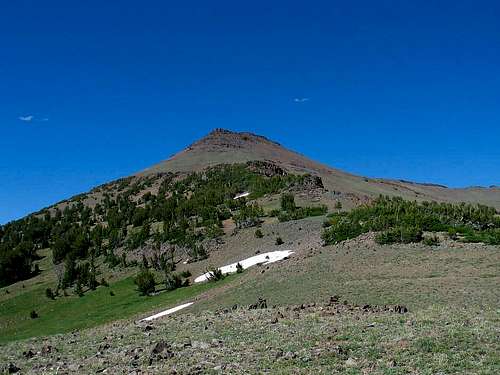
![Aneroid Mtn]() Looking back at Aneroid from near the trail
Looking back at Aneroid from near the trail
This area is horse country. Lots of horse people visit the trails of the Wallowas and you have to watch your step, especially around the fresh stuff.
Down and down I dropped, 5000 feet from the summit to the trailhead. That is a lot of step watching as I often did fancy footwork to avoid the steaming piles of roadapples. The grade of the trail was maddening also since it was made for horses. It took two miles for every 1200 feet of elevation loss and the 8 miles went slowly even though I was often moving a three mile and hour pace. Of course I had to slow down for the water crossings and extremely rocky spots and places where the water was running down the trail. Then a wrong turn near the bottom of the trail cost me about 1/2 mile of effort but after meeting several backpackers who had their tongues hanging out, I didn't feel quite so bad. One guy was carrying twice a normal load as the two gals with him weren't doing so well and he had taken on some of their loads.
When I got to the trailhead, I was pleased to see my wife who had decided that she wanted no more of the Lake Wallowa State Park camping zoo. The neighbors yapping dog was testing her sanity and a night of listening to it bark would be more than she could put up with. We drove home.
Miles hiked: 13-14 Elevation gained 2300 Elevation lost 5400
Comments
No comments posted yet.