Set-up and Approach
This year’s installment of my annual hike with
Flanders (real first name unoriginally the same as mine) brought us to the Wallowas in northeast Oregon. Since I first went to the Wallowas in 2003, I knew this was an area he would like to come to but for some reason, we always opted for the North Cascades on the years he came out here. But, it finally worked out and I had planned it for months as to which areas we would hit, studying maps and trip reports on SP. Of course, my plan only lasted for about an hour before it all completely changed but that is the fun of these trips.
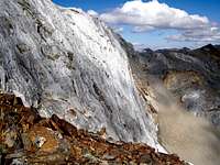
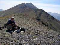
![GP & EC]() What it's all about
What it's all about
Anyway, Brian/Flanders arrived in Portland on a Thursday night at like midnight. Have to love what the airlines have done to normal traveling. Less flights, higher prices, no free food but then again Portland is not exactly an airline hub. Flanders was then unceremoniously deposited in the guest room at Chez Jenkins as soon as possible as I still had a half day of work the next morning.
After scrambling at the office to get things done, I got back home at lunchtime expecting to hit REI for any last minute items we needed and to be off for the mountains about 2 or 3 pm……………….I think we finally left my house at 5 pm. I can’t remember what the deal was but it involved dogs and cat care, getting lunch, me packing (had I forgotten to do that?), etc. We departed REI in Tualatin, OR at 6 pm. Thank God I had had the forethought to get a reserved campspot in the Wallowa Lake Campground as it was going to be midnight before we were there.
This was also the first year that another soul was going to be allowed to be with us on the entire trip. Mr. Flanders had wondered if I was going to bring the new addition to the Jenkins household on the trip, namely Luna, our 10 month old Border Collie/Lab pup (known as
Lunadog in these internet parts). I had not pondered the idea but he seemed to think it would be neat and my wife especially locked on to the idea because, well, you just don’t know what a Border Collie is like, do you?
These are herding dogs, dogs that need a job, dogs that get destructive if they don’t have a constructive outlet. It takes walking her several times a day, running her several times a day, teaching her things to keep her mind occupied several times a day or we end up with chewed up cookbooks, chewed up table legs, chewed up anything wooden, disappearing insoles, new aired-out underwear and socks, and on and on. One time she climbed a stepstool to get onto the counter to walk across the stove to get in the kitchen sink to get a toy on the window sill above the sink. The only way we figured out how her toy got on the floor from up there was by the paw prints on the glass-top stove. So, you get the idea. As it was, 10 days of a Luna-less house sounded appealing to my wife. I had visions of a perfectly responsive trail dog calmly leading the way and listening to everything I say and think and responding accordingly. (Shaaaaaa- and monkeys might fly out of my butt.)
The three of us drove without incident across the northern length of Oregon. Luna slept in back while Flanders and I listened to everything from Seal to Rage Against the Machine. It was about midnight when we got to the campsite. We were beyond tired and Flanders just put his sleeping bag down in the grass next to the car. Luna and I slept in the back of the truck. Did I mention this was Luna’s first time not sleeping in her bed at home? Needless to say there was not much sleep as she sat there all night checking everything out, barking at deer when they walked by (there were many), etc.
Day 1-3: Ice Lake Peaks
Morning came early and I was thankful. I wasn’t getting any sleep anyway and it was fine with me to get going. We ate and packed our packs and were off fairly early. A much better and quicker job than the day before getting out of my house.
I promised my wife that I would keep Luna on a leash although secretly I hoped we would get to the point where it wouldn’t be needed. Not though on the first part of our hike which was to be up to Ice Lake beneath the Matterhorn, Oregon’s version of it anyway. This was the hike I had first done in the Wallowas with a couple of other buddies years before and as I remembered it, Ice Lake was a dream of a campsite. It would not disappoint again.
The hike up the Wallowa River was pretty uneventful. Llamas and horses happen along with their people every couple of miles it seems and Luna alternated between being scared of them, curious or wanting to bark. We just gave a wide berth when we met them and enjoyed the ripe, wild raspberries that filled the valley this time of year. We frequently stopped to pick and enjoy.
![Waterfalls]() Waterfalls on the hike in
Waterfalls on the hike in
We hopped over the river and began our climb up to Ice Lake somewhere around noon I guess. The switchbacks up the side of the mountain go on for a while but there are enough views of the magnificent waterfalls, avalanche areas, butterflies, mountain valleys, etc. to keep one occupied and not thinking about the elevation gain with a fair-sized pack. Once the switchbacks end and we headed to the outlet for Ice Lake, I got really excited to see what Flanders would think of this area.
Ice Lake is a wonderful mountain-lined lake in the sky with grassy places to sit, deer jumping around, and goats to be seen high up on the mountains. The water is calm and the mountains reflect perfectly in it. There are about a dozen great sites and all are far enough apart you don’t hear anyone else (mostly). We set up camp and sat back to enjoy the day.
![Luna and me]() Lunadog and yours truly at Ice Lake
Lunadog and yours truly at Ice Lake
After dinner we hung the food in a tree about 40 yards away and at that time, about 5 or 6 deer came into our campsite. What was odd was that they knew we were there and they didn’t care. They play fought with each other and checked everything out. We were incredulous. They must be so used to people camping here they just don’t care anymore. At one point, the large male came over to Luna and me and appeared to want to push us around. We mock-charged a few steps and he retreated. Luna was doing her Border Collie instinct moves where she charges and then squats down low in the grass trying to give them the evil eye. It worked to some degree and the deer just kept to an open meadow next to us while we hung out before going to sleep.
![Synchronized Deer Urination]() Synchronized deer urination;just one of the many odd things they did at our campsite
Synchronized deer urination;just one of the many odd things they did at our campsite
The night though was not much better as Luna could smell and sense them everywhere and she growled from my tent all night. Thankfully, it only took one night for her to realize this was fruitless and unless something got REALLY close to the tent, it was best to just sleep through it.
The next morning was cold. Although it was mid-August, at 7500 feet in the Wallowas there was ice on Ice Lake. Fortunately, the sun came up as it usually does each day and things got warmer soon. I hooked Luna up to my newly patented Double-Webbing Harness System so that she would be attached to me by a leash and backed up to my backpack. The three of us hiked around Ice Lake on the normal route to the Matterhorn. The trails weave in and out in a confusing pattern of braids where it first leaves the lake and heads up but it’s easy enough to keep on course. We rested once in the soft alpine grass above the lake and below where it all turns to rock. It was a great morning hike and in no time we reached the summit where Luna decided to lick a cute girl’s face while I made apologies to the hikers who had reached the summit before us that morning.
![Flanders coming up]() Flanders hiking up the east slopes of the Matterhorn
Flanders hiking up the east slopes of the Matterhorn![Granite Walls]() Granite walls of the Matterhorn
Granite walls of the Matterhorn![Luna at the summit]() Luna on the summit of the Matterhorn
Luna on the summit of the Matterhorn
After snacks and photos, we headed north along the ridge connecting Matterhorn and Sacajawea. I had unfinished business from years before where I had attempted this route but never could find what I thought was a safe way across. I was hoping after a few more years of climbing experience I would be able to do so. I also knew that a buddy from SP, Cornvallis, had done this and told me you can always go lower on the west side if you don’t like the looks of things.
We made our way over to the sub-summit where the ridge connecting this ridge and the Hurwal Divide meet. It’s Point 9775 on the maps. Once there, we found the huge cave that dives down into the heart of the rock that I’d seen in
THIS photo on SP. We threw a few rocks into it but never did hear anything hit bottom. Best not to get too close to the edge there!
We scrambled down to the knife-edge going to Sacajawea and it became apparent that I would not be able to take Luna across. Lacking opposable thumbs, Class 3 is a bit out of her league and my comfort zone for her. Flanders didn’t like the look of it either so they both settled down for a rest in the only flat spot on that ridge while I attempted to cross it.
![Waiting on the ridge]() Luna and Flanders waiting on the ridge.
Luna and Flanders waiting on the ridge.
As I scrambled along, it occurred to me that I was probably picking the exact same line as last time. I just hoped I wouldn’t make the same mistake and get cliffed out somewhere. Where is seemed like staying on the ridge would get more technical, I opted to head on down lower in a diagonal line down the west side. I got around some gendarmes and onto mostly easy ground although at times, the footing was iffy on stones over hard rock underneath. A few jumps here and there to easier footing and I kept moving on. I headed toward a darker vein of rock where it looked like it would be more solid and I could make my way back up again to the ridge. Once I got there, it was only marginally better but ok enough I scrambled back up to the ridge to find myself past anything difficult with a clear path to Sacajawea.
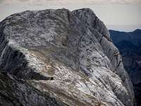
![The Matterhorn]() Matterhorn from Sacajawea
Matterhorn from Sacajawea
The hike from there was pleasant with great views. The summit of Sacajawea held no register I could find. I took some photos and viewed the Hurwal Divide to see if it seemed possible to hike that ridge with my group on the loop back to the car tomorrow but didn’t see anything that looked Class 2 or easier. I then headed back towards the Matterhorn and wanted to see if I could stay on the ridge or if I had to do the lower traverse again. Fortunately, I found what I would consider the “right” way this time. It is possible to stick to the ridge and any tough spots where it seems iffy, head to the west side and there is a way to avoid any serious exposure. A few spots on the east side would be dangerous and cliffy. I just avoided these two areas and found ways that coming from the other side don’t seem like the right way, but really are.
![Summit]() Summit of Sacajawea
Summit of Sacajawea
I got back to Luna and Flanders MUCH quicker that on the way over. We then did the short hike up to Point 9775 before heading east along the ridge to where you can ski the scree down to Ice Lake. And boy did we ski the scree! Luna loved it and in the sandy parts would run in front of me and dive head first into the sand. When we reached the bottom, we were tired and we rested at the base of the ridge. It’s amazing how in the Wallowas there is a definite start and end to the mountains. They come right down to a flat spot and end (or begin) in that spot.
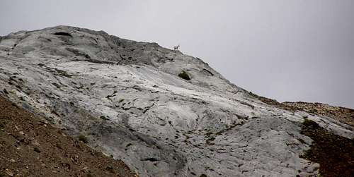
![Goat, ho!]() Goat on the Hurwal Divide
Goat on the Hurwal Divide
We picked our way back down to Ice Lake watching goats up on the Hurwal Divide getting back about dinner time, just in time to welcome the deer and make a nice fire.
The following day was just hiking out back to Wallowa Lake. This completed the first section of our trip but was not the end. We would be headed over east to the Aneroid side of things the next day. On the hike out from Ice Lake, we enjoyed more raspberries and sideswiping horse teams and it was pretty uneventful. I had arranged a dog-friendly room at the Eagle Cap Chalets and we got clean there and went into Joseph for dinner. Except there were no dog-friendly places we spotted in Joseph so we drove further to Enterprise where we found
Heavenly’s, a little greasy burger place with tables out back. The cook was great there and asked if I wanted a special treat for my dog which turned out to be leftover sirloin tips. Oh yes, Luna was happy and we were too with our recommended weekly allowance of greasy food.
Day 4-7:The Dry Side of the Wallowas
The next morning, we packed up and walked over to the tram that goes up Mount Howard. This is a ski mountain with a summit area and restaurant up top with great views into the Wallowas. Mt. Howard is the northernmost peak on a ridge that extends north from Aneroid Peak, one of the higher ones in the Wallowas. The ridge is probably the easternmost significant one in the Wallowas although there are a few lower ones before the Wallowas fall into Hells Canyon at the Snake River and the border to Idaho. The terrain here is a bit different than further west in the Wallowas in that it is much more arid and feels like Utah and the old west with mesa-like peaks, sagebrush and open grassland.
The tram does not allow pets, they don’t want them on the grounds, they don’t want them on the tram (per all the signs there). But, when I had emailed to find out about the possibility of taking our packs and Luna up the tram a few months earlier, I must have gotten someone who was having a good day. They let me know that if we were hiking in and not coming back down the tram, they would allow it but they needed advance notice so they could let the workers know that day it was ok. WAY COOL! The evening before when we got to the Eagle Cap Chalets, I had walked over (it’s right next door) and let them know so everything was a go for our easy ascent to the summit of Mt. Howard. They told me there was a fire going now in the Lakes Basin region and we might not be able to get over there if we were headed there (we were ultimately).
Well, technically everything was ok for the tram, I still had to convince the pup that this big noisy contraption spinning metal cars over her head was a good place to be. After ditching the car at the trailhead we’d be hiking out to and running back the half mile or so to the tram, I then had to convince Luna to walk up with me and board the tram. It was obvious she wanted no part of this, no matter how many treats I gave her. Tail between the legs, cowering behind people in line, it took us probably 3 or 4 attempts in line, only to get out of line so she could regroup, to try it again before we made our way up to the guy at the tram. It was a sight seeing us try to load 2 heavy packs, ourselves and a non-willing dog onto the tram in the amount of time normally allowed for skiers to get in and keep the line moving. But somehow we managed and up we went.
Once on the tram in the quiet air, Luna just sat on the floor while Flanders and I sat there sweating. At the top, Luna was more than happy to hop out and things were back to normal. We headed to the summit area of Mt. Howard where we expected to see the trail heading south to East Peak. Of course, that was the wrong spot and we had to backtrack a couple tenths of a mile to where we first came from and find the trail that really headed down east before heading south under the summit towards the ridge we wanted to traverse today. It was hot and open land with a lot of weeds and sage. Some trees here and there but we just saw a row of humps in front of us. After looking at the map, I determined we could see East and Hidden Peaks and probably not Aneroid. Boy was I wrong.
We stopped under some trees after about 45 minutes for a quick break that turned into a leisurely break. From there on we were in pretty much treeless sun the rest of the way. We made our way up one hill to find more ahead of us. We continued through the sun to the next hump of land with Luna munching on grasshoppers as they jumped in front of her. We managed to find a shady spot under some stunted trees (maybe juniper?) and set down packs to tag the summit of East Peak upwards to our left. The three of us picked our way up the faded grass and red rock slope watching out for rattlers we expected (but never saw) to the ridge and could see a cairn to our right. We hiked over to it, congratulated and took photos happy that East Peak was complete and we were making pretty good time.
![(False) Summit shot]() Luna and I on the summit of East Peak....except that East Peak is actually the mountain in the far distance. No wonder we thought we were making great time.
Luna and I on the summit of East Peak....except that East Peak is actually the mountain in the far distance. No wonder we thought we were making great time.
Back at the packs, we continued on the trail which then went up to the ridge crest and picked it’s way through the rocks scrambling back and forth up and down along the edge. Great views east, west and south. Crap! Now that we were up higher and could see the actual ridge we were on, it was apparent we were nowhere close to East Peak yet. Who would set up a cairn on a false summit where no trail went? Evilness! The cruelty!
An hour or so after the false summit, we crammed under a shrub for some shade and another snack and figured we were now behind schedule. Ah, screw the schedule, we were on vacation. There was one long slope up to East Peak which we eventually did come to, as anticlimactic as it was. On the top there, we could really see the rest of the ridge to Aneroid which looked……………..REALLY far away! We also noticed the haze to our right which would be the fire in the Lake Basin region they told us about at the tram. We would have to rethink our plan of heading over there now.
![The real summit]() The real summit of East Peak
The real summit of East Peak
Down the south slope of East we went towards Hidden Peak with Luna eating more flies and grasshoppers. The carnage was magnificent and tales will be told in the insect world of Luna the Destroyer. As we ambled down in the hot sun the trail rolled onto the west side (right as we were looking at it) of Hidden Peak. We followed along tired and smelly. We came to the realization that this was really another hump on this ridge and since it was technically labeled as one peak (East and Hidden Peaks) on Summitpost, did we really need to tag it, late as we were? As you can imagine, the answer was no. As bad of peakbaggers as we are, even Flanders and I don’t see the need to put our foot on the top of every name on a list that much. We decided to just forego the trudge up a couple hundred feet to our left.
On the west side of Hidden though is a nice snowfield, still in mid-August. I forgot to mention that Luna REALLY loves snow. Loves to eat it, lay it in, walk in it, dive into it. She saw that and pulled me along. We took a nice break there in the snowfield among the desert, it was an odd sight. We walked through it to where it ended and made our way onto the ridge that headed towards our final objective that day, Aneroid Peak.
But wait, there is another false summit! This one we could see though so not really a heartbreaker. There is a lower rocky ridge where we ended up a half hour or so later where we ran into the first people we had seen since the tram. A couple with their humongous Bernese/Mastiff-looking thing. They asked if he could meet our dog since it was the first people they had seen in 6 days of hiking and their dog was really wanting some dog time. We obliged and after the ritual butt-smelling, they settled down next to each other while we chatted with them for a bit. Breaktime over, we kept on trudging up the sub-summit where we took another break a bit later. At this point, I was reasonably confident and let Luna off the leash. She walked around a bit, came back over to us and sat down next to us. So much for the crazy puppy she started out as.
From there we had a long slope upwards and south to Aneroid, a big, beautiful mesa-like mountain out of a John Wayne movie. It was easy but steep hiking up an open slope and it took us some time but we made it to the summit as the sun was nearing the western horizon. There was a summit register there that we signed and then headed down the north side. We’d heard different reports of it being everything from cliffy and third class to being easy. Thankfully, it was easy. There are a couple spots where one could get cliffed out on about a 20 foot cliff but those spots are easily gone around. We ambled on down easily enough to the bottom. From there we made our way through the grasses of a wide saddle to Dollar Lake and our expected campspot.
![Lunadog and Aneroid]() Luna at camp with Aneroid Peak behind.
Luna at camp with Aneroid Peak behind.
Dollar Lake looks like it is in the middle of nowhere but really is in the middle of everything. North of it was the ridge we had just hiked. West is Pete’s Point and a couple lakes. South heads into the valleys just east of Sentinel Peak and Cusick Peak. East are forested ridges with the Bonny Lakes area, Mt. Nebo and on to Hells Canyon. Here at the lake, there are a few tree groves but mostly open grassland. So, being in the middle of nowhere with plenty of room to roam and see everything, I let Luna off the leash again. She promptly curled up and went to sleep in a little ball near the flat spot we decided to pitch tents on. It had been a long day for her too.
We set up camp and I went to the lake to filter water. Luna followed and suddenly realized she was FREE! She grabbed a branch in her mouth and ran along the shore of the lake enjoying life while I……….pumped……water. For a long time.
We had a nice fire that night and watched satellites and stars. No moon and endless stars. The haze had gone away and the night was clear. Not a bad way to end a day.
The next day we talked about what our plan should be. It seemed the Lakes Basin would be out now. Our plan had been to climb Petes Point the next day, head over to Sentinel, camp at a lake on the south side of Sentinel and then pick our way down to the Lakes Basin. From there, on to Glacier Peak and Eagle Cap before ultimately heading all the way over to Brown and Glacier Mountains. We decided that since the long day we just had was supposed to be our easy day, perhaps the mileage belies the difficulty of the hike in the Wallowas. There is a lot more up and down that you think, especially with a heavy pack set for 5 days. I’m glad we came to this decision because now in retrospect, the thought of climbing Petes Point with a full pack and a dog on a leash, going down and up to Polaris Point to go down and up to Sentinel Peak to then go down to a lake was ridiculous.
We decided to have Dollar Lake as our basecamp and go peakbagging over the next couple days before heading back out. Today would be a rest day though and we’d just enjoy this lake and take it easy after 4 days of good hikes.
![The Dollars]() Dollar Lake and Ridge
Dollar Lake and Ridge
Of course that didn’t last long.
There is only so much sitting around I can handle. I kept eyeing this ridge hanging over Dollar Lake thinking maybe I could just hike up there to see what is around. Flanders did not have any interest in it, being much more sensible and understanding as to what an “off” day really meant. I didn’t want Luna heading up with me in case it got scrambly either. So, about mid-day I started up the northeast ridge of this ridge and even though it looked like a long ways, surprisingly it went really fast and I was up on top in no time. The other side was not a precipitous cliff but really a sloping grassy hill, nothing scrambly about it. On the ridge, I noticed these huge red crickets jumping everywhere. They were like 3 to 4 inches long and a bright brick red. Very weird.
Once I walked over to the high point on the ridge, I actually found a summit register. Seems this was called Dollar Ridge. So, I signed it and then walked down to where I thought I could scree-slide back down to Dollar Lake, however, the slope was steeper than expected so I went a bit slower. And the scree was really gravel, so not as nice. I went down the gully that connects to the ridge above the west side of Dollar Lake but it would be much easier (although longer) to walk over closer to Tenderfoot Pass and walk grassland back. Anyway, I got back to the lake and camp and hung out the rest of the day. Apparently, Flanders had gotten bored as he had made a miniature version of the Mt. Howard to Aneroid Peak Ridge out of dirt, pebbles and rocks. Later, another starry night with a great campfire. I did notice something swooping over our heads though once in the headlamp light. More about that later.
The next day we were planning on breaking camp, hiking towards Pete’s Point, dropping the heavy packs, tagging Petes, Polaris Point and Sentinel before coming back and maybe camping at Aneroid Lake. Man, am I glad we had the foresight to call that off and think more realistic thoughts. We had given up on the Lakes Basin region idea and now were thinking maybe we should just head up Petes Point and see how we feel and what we want to do afterwards.
We broke camp and headed west to Petes Point which we could see the whole way. There was a series of small valleys between us and it so I had the idea to skirt the scree on the left below Dollar Ridge. This was not a good idea as it really is not scree (why did I not remember this from the day before I don’t know.) It’s steeper with small boulders that just want to eat ankles and trap dog feet. We gingerly picked our way over with Flanders and I being snippy about it-well me more snippy and him more like “Dude?” and Luna looking at me like “where the hell are you taking me?” Eventually, we both just headed down to more grassy flat parts to climb back up to the base of the east ridge on Pete’s Point. It was already hot with no shade in sight. Flanders went right on the hike up from the base of the valley and I took Luna left.
At this point, Luna got fed up with my leadership abilities and sat down. I could only coax her up a few more steps and she laid down again. I then took the pack off her that she carries with her food, water and little protective shoes and carried that in my left hand. So here is me with a 5 day pack on, doggie backpack in left hand connected to a dog who doesn’t want to move and trekking pole in the other hand. It was this sight that greeting Flanders when we met near Tenderfoot Pass. Actually, I had gone a bit higher up the hill, Flanders could sense I was not in the best of moods and he came up to sit with us from where he was.
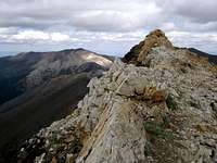
![Petes Rainbow]() Petes Point
Petes Point
We ditched the packs and headed up Petes Point after a short break. I will say there is nothing like having a good buddy make a smartass remark to slap one back into reality. Flanders has done this time and again and whenever I start becoming an asshole, I am reminded that my life is pretty good and I need to shut my trap. (I do hope eventually to return the favor though.)
The first part of this ridge up Petes Point is easy grassy steep slopes. There is a climbers’ path we found that eased us up to the rocky ridge. This part was reddish volcanic-looking stuff but about halfway up, it changes to grey rock. We came to a section where there is a short Class 3 step about 4 or 5 feet high. The ridge narrows to a couple feet wide here too with steep drop-offs on both sides. At this point, my only concern was for Luna who could not make this move on her own. I did not want to get into anything where we shouldn’t be with a dog so I was slightly annoyed here. I wish this would have been mentioned somewhere. Anyway, Flanders made the move and I lifted Luna up to my head height where he secured her leash ahead of me and I was able to put her in a position where she could claw her way up to him. Then, I made the move and we kept going up.
From that point on the steepness lessened and there was only one other point in the grey rock band where I had to lift her again onto a Class 3 ledge. After this, it was easy hiking on the ridge over to the summit.
We rested on the summit a bit before deciding to head down. It was about noon and we did not know whether to take the south ridge over to the one that headed back east down to Tenderfoot Pass (completing the other side of the crescent that is Petes Point) or to take the ridge extending south to the saddle between Petes and Polaris Point. Once we got over there, we decided it looked easier to hit the saddle. It looked like a lot of up and down to continue on to any other peaks that day so we just determined we would head down and then over to either Jewett Lake or Aneroid Lake.
The slopes down the south ridge are pretty easy and we made pretty good scree-skiing time down. Once in the saddle we were dismayed to see the “easy” slope down to the Polaris Trail 1831 that leads back to Tenderfoot Pass to the north now appeared to be steeper than expected and full of loose rock. The plants that grow there basically just cover this fact and make it look nice and easy. But, there were a few parts where we slid on our butts. Luna hated this section and laid down several times in her “I quit” posture. I couldn’t blame her, these rocks that moved and slid all around my heavy boots must have been excruciating to her feet. I did have her booties on her to protect her but her limbs are much thinner that mine and her feet slide into a lot more nasty places than mine on a rocky slope. I managed to coax her out and sometimes pulled the leash and caught her when she slid. It was not fun and I got plenty of those “You asshole!” looks from her here. Those of you dog owners out there, well, you know exactly the look I mean.
It took us probably over an hour to negotiate this down from the summit and we were exhausted in the hot afternoon sun when we reached the trail. Just below us a few hundred yards was a big white snowfield. Knowing that this would make Luna’s day, we made a beeline for it and collapsed onto it. Luna stretched herself out over it to get as much of her belly on it as possible. Flanders and I plopped our butts onto it and instantly felt air conditioned. You know it’s hot when you are sitting on snow and you are not getting numb, when it still feels pleasant the whole time. We sat there for probably a half an hour not wanting to get back up to the dusty trail and continue in the sun to the next camp site. But, eventually we did get up and scrounged our way back up to the trail.
![Snowdog]() Luna finally getting some stress-free cooling on in a snowfield on the flanks of Petes.
Luna finally getting some stress-free cooling on in a snowfield on the flanks of Petes.
From there it was really just a hot slog with one break in some shade back north to the Pass, up and over it, and a hard right turn to where we had stashed the packs. At that point, it was probably 4 pm or so and we just wanted to get to a camp. We opted for the closer Jewett Lake because it was, well, closer. We also saw what looked like a gully up to the south ridge of Bonneville Mountain and figured we’d hit that the next day, this being one of those free days now since we could not get into the Lakes Basin. Once over to Jewett Lake, we were pleased to find nice accommodations in that no one else was there (we had now not seen anyone else in a couple days), plenty of water and more importantly, shade.
![Petes Point from Jewett Lake]() Petes Point from our campsite at Jewett Lake
Petes Point from our campsite at Jewett Lake
We rested in the shade a while before setting up camp on the east side of the lake between it and a high rock wall separating the lake area and the valley descending down to Aneroid Lake. After that, we had our dehydrated meal and Flanders set up the night’s fire. When it got dark, Luna decided she had had enough of our company this day and walked over to my tent with her nose on the screen zipper. I took this to mean she wanted to retire for the night and she hopped in the tent and curled up while we sat outside enjoying the fire and another clear night.
It was odd, it being clear this night as we were closer to the Lakes Basin region. We wondered if this “fire” had turned out to be much smaller than originally reported and if we should have headed out there. But, we were feeling beat up and tired and would be happy with tagging Bonneville the following day and then, having one more day left on our trip, we could find some trail to dayhike some other peak. As we sat by the fire, we saw something swooping overhead. I raised my headlamp to see it was a rather large owl. He came down within about 10 feet of us I would guess. Never heard a sound. Soon, there were two swooping over us. I took it as a good omen and that there might not be many mice wanting to get into our stashed packs.
Our objective the next morning was the South Ridge of Bonneville Mountain. We identified the gully to hike up from the route page on SP and got up there early in the morning. Once there though, I quickly realized this would not be possible with a dog. The other side is a Class 3 downclimb which canines have issues with. We then edged our way around right to see if there was another way to get over the cliff area. This was an even bigger mistake as it was loose as a greased goose. I managed to edge over with Luna attached to me to where there was more solid rock although it took some minor jumps of faith. Again though, once up on the ridge, this area looked worse than the other being cliffs of about 40 feet.
We painstakingly made our way back the same way we came and back down the gully dejected. It was approaching noon now and we did not think there would be enough time to get around to Aneroid Lake and up one of the loose slopes there to Bonneville with enough time to hike out. So, we sadly gave up on Bonneville.
![Bonneville]() Bonneville laughing at us on our hike out
Bonneville laughing at us on our hike out
The hike out was just a long trudge, although beautiful. After breaking camp, we got back to the East Fork Wallowa Trail 1804 that then descends into the valley between Bonneville Mountain and the Aneroid Peaks Ridge. After spending 3 days in hot, arid red-rocked open spaces and peaks, it was nice to slowly fall into the forests and flowers to Aneroid Lake. We had lunch around Roger Lake on the trail and continued then almost nonstop to the dam and falls where the trail starts switchbacking down to the West Fork Wallowa Trail 1820 (where we had come out from Ice Lake days before) and before we knew it (well, half a day later) we were at the car.
We went back to Enterprise for some Subway foot long sandwiches (sing it "Five....Five dollar....Five dollar foot-loooong.") before deciding to head further east for our last day. After being shut out on several of our wishes for the Wallowas, we wanted something with an almost guaranteed success factor. We looked at the maps and decided on Mt. Nebo on the eastern fringe of the Wallowas. We had no information about it but it looked like a fairly easy one on the map with a definite trailhead. This meant driving east from Enterprise and into the Hells Canyon Area.
I expected to see dry, cliffy gulches but was extremely surprised to find that, for the part we were in driving to Lick Creek Campground, it was all thick forest. Granted we did not get over to the Canyon this way but still, we camped near a rushing creek with salmon. There were signs at the campground for not only cougar and bear but also wolves. Every now and then, the reintroduced ones from Idaho make their way over and set up territory here. Usually, you hear about the ranchers throwing a fit and then having approved hunts to eradicate them but it was nice to see the possibility of them being there. (We did not see any.)
That night was cold. I slept with Luna in the truck and Flanders had a tent outside. The next morning we got up early and were off to find Mt. Nebo. It actually was just up a side road off the one we had driven in. There were a few cars there already but soon we were off in the morning sun.
Day 8: Wrapping it up
The trail crosses a large creek that at once caused problems. Luna did not like the looks of the downed tree bridge there so we ended up having Flanders cross first and then calling Luna from the other side. She walked through the creek to him and then I came over the tree bridge. After that is was pretty smooth-sailing on the well-graded path. The route would take us through woods and meadows and up to a ridge where we would have to go off-trail to the summit. In one of the meadows we met up with a group of hikers consisting of one guy and like 6 attractive women. I remarked to Flanders that, wasn’t this the way most Penthouse Forum stories began? “I never thought it could happen to me but, one time while hiking with my sister’s friends…………….” Anyway, we silently saluted the dude and his harem and kept on our way.
The trail started breaking out of the thicker forests as we ascended up to the ridge. It’s a very deep horse trail in the dirt from a lot of use but at least there is no losing the trail. Once up on the ridge, we could see what we thought was the summit and where we should go and we took a hard left off the trail and onto the more-or-less open ridge. We followed a game trail or climbers path most of the way. But, as long as you stay your best on the ridge, it's fine. We hiked a bit until we came to the bottom of an open grassy area with cliffs on the left. Up through the grasses we went until we looked around and found ourselves on the high point. We confirmed it on the map and declared ourselves victorious.
![Directly West]() View from Nebo of Sentinel, Polaris, the snowfield where we rested two days earlier and Petes
View from Nebo of Sentinel, Polaris, the snowfield where we rested two days earlier and Petes
It was a great day, blue sky, not too hot and the views were the real payoff. We could see everywhere that we had hiked on this trip. We could see over to the Matterhorn-Sacajawea area and directly in front of us were East, Hidden and Aneroid Peaks. To our east we could now see without strain the Seven Devils Area in Idaho and all the valleys around were forested with snow fields and lakes. It was truly magnificent. We lingered there a while taking photos and enjoying it before heading back the way we came. We went pretty fast on the way out as we had a goal to be out by 1 pm to be back in Portland in time for dinner.
We missed the time but not by much. On the way back, I walked through the creek with Luna soaking our feet. ‘Twas nice. We got the car set for the long drive back with Luna perched behind us on the folded-down back seat. She seemed to know exactly what was happening and settled in and went to sleep quickly. We missed our deadline to get home as we were stopped by a motorcycle accident on the way out. On the windy road from the trailhead to Joseph, a rider did not negotiate a curve and when they motioned us past the scene they were extracting the bike off of him. We heard his moans as we were waved past. Not good.
Fortunately for us, the drive back was uneventful. Long, but uneventful. We got home in time to go to my favorite pizza place in Portland,
Mi Famiglia, in Oregon City. The next day, since we had hours before Flanders late flight back to Massachusetts, we drove out to Saddle Mountain in the Oregon Coast Range and hiked it with Luna. Another new summit for both of them. Was cold but humid, especially compared to where we had just come from, and we both remarked on the difference between the two areas of Oregon. Views were marginal this day and we were back in Portland early afternoon with lots of smelly clothes, some blisters and lots of photos on the digicam. Just the way you want to end a trip like this.
Next trip-New Hampshire 2010 and more 4000’ers there!
![Camp at Jewett Lake]() Until next time....
Until next time....


Comments
Post a Comment