Another Winter Ascent of North Thunder Mountain
Thunder Bowl towers over south Salt Lake Valley and is clearly visible from most of the city. The ridge connecting North and South Thunder Mountains lines the east side of this bowl. Several weeks ago my friends and I climbed South Thunder. Today our goal was North Thunder, elevation 11,150', a 6000 vertical foot and 5 mile climb. Of the 32 peaks in Salt Lake County over 10,000 feet, North Thunder's got my vote for the hardest. It's the one I've climbed the least often and is the only one I haven't done solo. Today was my fifth trip and first winter ascent.
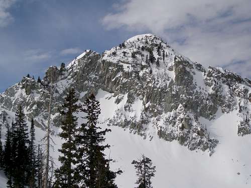
![Cliffs Lining Bells Canyon]() Cliffs lining Bells Canyon Cliffs lining Bells Canyon![Trudging up from the Meadow]() Trudging up from the meadow Trudging up from the meadow
The direct route to North Thunder follows the Bells Canyon Trail until a meadow is reached at about 7800'. In the summer, this trail is overgrown and the footing is poor due to the trail being strewn with boulders. At the meadow, the trail crosses several small streams and heads south. To get to North Thunder, leave the trail at the south end of the meadow and head east, bushwhacking up a very steep hill. At about 9400' bend south and follow the drainage up to Thunder Bowl. In the summer this bushwhack would be arduous. Since branches tend to grow in the downhill direction, bushwhacking downhill isn't as bad, but is still nasty. I've done it downhill twice, swearing each time I'd never do it again. In addition to dense brush, the ground under foot is very uneven and prone to numerous obscured 2 foot drops. But, today it was all buried under snow and was a very pleasant and direct route to Thunder Bowl. Once you reach about 9800' the terrain opens up as you enter into the bowl and bushwhacking is minimal.
|
After our South Thunder trip, Michael, aka
Moogie737, was eager to try North Thunder and kept pushing for it. At the last minute, he canceled the first trip he had planned due to poor weather. Two days later, he, Lana, and Brent set out from the trailhead on Little Cottonwood Road, Route 209, N40 34.306 W111 47.814 up Bells Canyon, elevation 5200'. They planned to go up Thunder Bowl and then to North Thunder, but just as Joe and Grizz had done (see
A Fine Finish to 2006 - Winter Ascent of North Thunder Mountain), they missed it completely and found they were on their way to the north ridge of North Thunder far above Thunder Bowl. They traversed south on the ridge but aborted just to the north of a small notch, a mere 400 horizontal feet and 80 vertical feet from the summit. Conditions on the summit ridge were deemed too dangerous to continue. The next window of opportunity was 5 days later, Tuesday March 11, but bad weather was predicted. Fortunately the storm fizzled and Michael decided late Monday afternoon to give it a go. After the failed attempt, Lana, Brent, and I were not too enthused, but Michael was raring to go. We hadn't heard from Dave, but in typical Dave fashion, he decided at 5AM that morning that he would join us and showed up at the meeting place.
![Bells Cleaver 10488]() Bells Cleaver
Bells Cleaver
![Rocky Mouth Canyon Peak 10292]() Rocky Mouth Canyon Peak 10292 Rocky Mouth Canyon Peak 10292![Lone Peak and Bells Cleaver]() Lone Peak and Bells Cleaver Lone Peak and Bells Cleaver
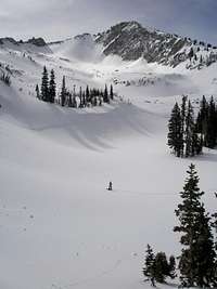
We got under way at 7AM, 45 minutes before sunrise when it was just barely light enough to see. The lower section of the trail was well trod and the snow was packed but about 1:15 into the trip the tracks thinned out until finally the only tracks remaining were the 5 day old tracks of Michael, Brent, and Lana. We arrived at the meadow about an hour later. Going up the sun baked and crusted slopes from the meadow following their old tracks was all too easy and I felt like I was cheating. At about 9400' we started diverging, heading south to the base of Thunder Bowl. To make sure we didn't mess up, this time we used a GPS. As we approached our destination, we had great views of Bells Cleaver 10488, Rocky Mouth Canyon Peak 10292, and Lone Peak 11253.
|
![Dave]() Dave Dave
![Trudging up Thunder Bowl]() Trudging up Thunder Bowl Trudging up Thunder Bowl
At the base of Thunder Bowl, four of us turned east and went around the 10120 bump to the north, but Dave, the lone wolf, went around it to the south. We continued east up the steep slope to the ridge, crisscrossing ski tracks as we went. At about 10,800' things started to get a little dicey with the snowshoes so we switched to crampons. This was easier said than done because we were on a very steep smooth slope and anything unsecured would have coasted down 700 feet or so.
|
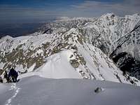
![Summit ridge]() Summit ridge
Summit ridge![Looking south]() Looking south
Looking south
The advantage of going up Thunder Bowl vs attaining the north ridge earlier is that you have more options. You can either ascend to the notch where Michael et al. turned around, go up a swath of snow just south of the notch, or bypass the whole mess altogether and reach the ridge south of the peak and then travel north on the ridge to get to the summit. The later is probably the easiest but the longest approach. We debated which way to proceed and decided to try the notch again. The final 10 feet to the ridge and the first 50 feet along the ridge involved some careful scrambling. But shortly the ridge mellowed out and we were there! We gained almost 6000' of elevation in 5 hours and 35 minutes. The summit mailbox and register were buried, but we found them about a foot down, just north of the summit rock.
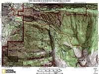
![Bells Canyon route to North Thunder]() Bells Canyon route to North Thunder
Bells Canyon route to North Thunder
We encountered several sets of ski tracks. They went up the same general way we did, but when they got to the top of the notch, they turned north instead of south to the summit. Maybe they'd been up here so many times in the winter that it was just ho hum to them and wasn't worth it to go the few extra feet to the summit. But, being up here in the winter was all new to us and there was no way that we weren't going to the very top.
Participants
![Brent]() Brent Brent
|
![Dave, Michael, and Lana]() Dave, Michael, and Lana Dave, Michael, and Lana
|
![Me]() Me Me
|


Comments
Post a Comment