
-
 38023 Hits
-
 91.06% Score
-
 34 Votes
|
|
Mountain/Rock |
|---|---|
|
|
40.54350°N / 111.7314°W |
|
|
11150 ft / 3399 m |
|
|
Overview
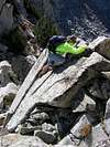
North Thunder Mountain is the slightly lower (by 4 feet) sister summit of South Thunder Mountain, which is located approximately 1 mile to the south. The two peaks are connected by a long and rugged ridge which divides Hogum Gulch on the east from Thunder Bowl on the west.Long approaches, difficult scrambling, routefinding, and significant elevation gain ensure that North Thunder will be a challenging hike, regardless of the route chosen.
This is a seldomly visited mountain; based on the summit register the peak typically sees only a dozen or so visitors per year, despite the fact that the mountain directly overlooks the Salt Lake valley with a population of over one million.
USGS Quads:
 |  |  |  |  |
Getting There
The three most commonly used routes for an ascent of North Thunder Mountain are as follows:See the individual 'Routes' section for trailhead directions and details on ascending the peak for each of these routes.
A challenging day is accomplished by combining an ascent of North Thunder with an ascent of 3 other nearby peaks; South Thunder Mountain, Bighorn Peak, and Lone Peak. Details of this route are contained in the Hematoma Quad route description.
A more difficult route up North Thunder is the hypodermic needle route, accessed via Hogum Gulch.
 |  |  |  |  |
Red Tape
North Thunder Mountain is located in the Lone Peak Wilderness Area. No fees or permits are required for hiking in this area, but the following regulations apply:The Bells Canyon trailhead passes through a residential area, so please show respect to the property owners.
 |  |  |  |  |
mtn runr - Aug 5, 2007 3:49 pm - Hasn't voted
Lonliest peak in the WasatchI placed a PVC tube and a spiral notebook inside the old Ute Alpine Club mailbox on the summit on August 5, 1997. When we visited the peak on August 1, 2007, almost exactly 10 years later, the spiral notebook was less than 1/2 full!
_michaelmangum_ - Jun 9, 2016 10:27 pm - Hasn't voted
Re: Lonliest peak in the WasatchAnd I signed it today! Only the 6th in the register thus far in 2016.