-
 5231 Hits
-
 87.76% Score
-
 25 Votes
|
|
Mountain/Rock |
|---|---|
|
|
43.86684°N / 102.27373°W |
|
|
Spring, Summer, Fall, Winter |
|
|
3024 ft / 922 m |
|
|
Overview-- Where the Buffalo Roam
As I wrote in the trip report "Where the Wild Things Are," wilderness is not always some place miles and miles from the road, far on the other side of those ridges you see from the parking lot. Sometimes, wilderness is just feet from the car.
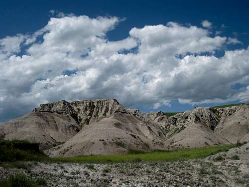
So it is in Sage Creek Basin, the heart of the Sage Creek Wilderness Area in Badlands National Park. A realm of eroded buttes, rolling prairie the likes of which the Sioux once roamed as they followed the herds of bison, and jagged ridges and spires, the basin, where there are no maintained trails, only those that the hooves of bison and deer have worn into the landscape, is truly an American wilderness, a relic of the pre-pioneer days and a glimpse of what the West was before wagons rolled across it. Once you step into it, it is a different world and a different game, and the road and your car on it seem far, far away, almost literally a world removed.
So removed and pristine is it, in fact, that as I entered it the last time I was there, I could not help but feel and hear the score of Dances with Wolves, long a favorite film of mine and recently having climbed into my top five, in my head. After all, part of the film was shot in Badlands National Park, and the setting is the Great Plains of what is now the Dakotas. So grand was the feeling and so sweeping were the views that I even broke a rule of mine and carried my MP3 player just so I could listen to that music-- on the way back, though, for I always go with only the sounds Mother Nature provides on the way to a peak. (Listening to music surely contributed to one of my close encounters with a bison; see the section on bison for more.)
The United States has done a pretty good job protecting its mountains but a poor job protecting the prairie, a once-vital ecosystem that sadly lacks the sexiness of the mountains. Except for national parks such as Badlands, Theodore Roosevelt, and Wind Cave; a few state parks; and a few nature preserves, almost all of the original prairie has gone over to grazing and crops. In Sage Creek Basin, the prairie meets with dramatically eroded badlands in a magical place where the buffalo still roam.
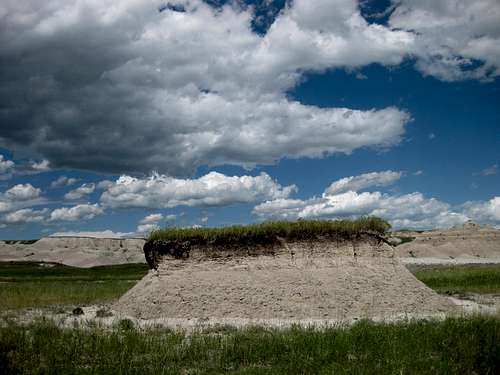
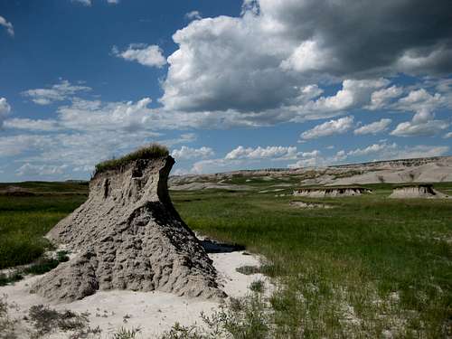
Anyway, Antler Butte, which you will not find named on USGS topographical maps but will find named on a park interpretive sign, is a small but attractive peak in Sage Creek Basin and is far enough from the road to make you feel as though you are truly in the middle of nowhere (though it doesn't take much distance at all out here to achieve that feel-- basically, losing sight of the road is enough).
Along the way and on the summit, there are no obvious signs of human presence.
Note on coordinates-- Since Antler Butte is not marked on official topographic maps, I have done my best with pictures, maps, and memories to locate the exact coordinates. I believe I have the correct ones, but I do not recommend that anyone wishing to climb this peak enter the coordinates on a GPS device and then use that to get there. Instead, use the pictures on this page to locate the butte, which is easily seen from the road; it should be impossible to fail that way.
 Where the buffalo roam...
Getting There
From the main park road, near the Pinnacles (northwest) Entrance, turn onto Sage Creek Rim Road and follow this good gravel road about 2.5 mi to an overlook that on some maps is called Grassy Tables Overlook and on others is called Hay Butte Overlook. Park here or anywhere along the road (do not block the road) for the next mile or so and find a way down from the rim to the basin to begin your cross-country approach to Antler Butte. An interpretive sign at the overlook identifies formations such as Hay Butte and Antler Butte.
If you reach the Roberts Prairie Dog Town, you have gone too far. You can still approach the peak from just about anywhere in the basin, but you will be making the approach much longer.
The closer you park to the overlook, the steeper and more difficult your descent to the basin will be. The farther you park from it, the easier the descent will be, but the route will be a little longer. My descent took me down a steep gully that quickly turned into Class 3 and even a little Class 4 conditions. The gully narrowed and deepened until it was tighter than many slot canyons and even a lean guy like me couldn't walk through, forcing me into some straddling and stemming. Such conditions are common on the edges of the rim. The easiest descent (and the way I regained the rim after the climb) seems to be by the beginning (or end, depending on your approach direction) of a fence northwest of the overlook. There, some gentle clay ridges lead smoothly down to the basin floor.
Route Information
My route was 1.7 mi from the basin floor to the summit, so it was probably about 2 miles in all. From the rim to the basin floor and then to the base of the butte, there were several ups and downs, and there was a net elevation loss of about 250'. The summit push climbed about 250', but that was in less than 0.2 mi, so it is a very steep grade.
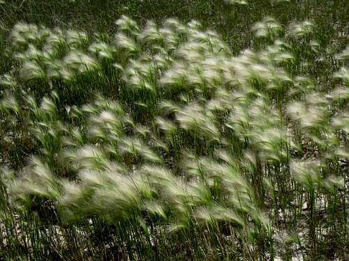
There are no established trails, but there are numerous game trails that can help you through the grass and the sagebrush even if they're not always so direct.
You will cross Sage Creek and some of its forks, and there will probably be water in them, but the crossings should not be difficult.
From the base of the butte, I hiked up a clay ridge and then followed a line of trees to the summit. Although it is not an ironclad rule, I have found that in general, if there are trees, one can hike or scramble up the slope. Going down, I followed a ridge and gully system that I thought looked more interesting, and it was, but it had several spots of tricky and loose Class 4. Most people will probably prefer to go down the easier way they went up.
 Summit panorama-- click and then view in "Orig."
Bison Warning
I can't overstate the importance of watching out for the bison. Large and clumsy-looking as they may appear, they sneak up on you, or rather you sneak up on them. Twice on my return hike from the peak, I rounded a small butte and found myself very close to a bison that didn't seem particularly glad to see me. The first time was a total surprise; the second time, I had noticed signs a few minutes before and was at least on the lookout.
The most obvious signs to watch for are fresh piles of scat, which are easy to both see and smell (and step in if you're not looking), and spots where the grass has been flattened by a resting bison; those spots look like huge beds in the prairie. The more pressed down the grass is, the more likely it is that a bison has been there recently and that the bison is nearby.
Bison are grazers, of course, but they are unpredictable and have been known to charge people. With their bulk and their sharp horns, they can do a nice job trampling and goring a person. Remember that they are not cows but rather wild animals; people commonly intentionally get way too close to bison, and occasionally the encounter does not end well for the human.
In a close encounter with a bison, the course of action is similar to the initial one when someone encounters a grizzly bear at close quarters-- move away in a sideways direction, keeping an eye on the animal but not making direct eye contact. Do not run. Talk in a loud voice but not a frightened one. And then try to put something substantial like some trees or a mound between you. If the bison does charge, try to climb a steep mound as quickly as you can, for the animal probably cannot climb it after you. And if you have nowhere to go and the bison does charge, you then have nothing left to do but hope it's a bluff or that it doesn't kill or seriously injure you.

Clothing Recommendations
Unless it's just too hot, it's a good idea to wear long pants in order to protect your legs from the brush. It was a hot day for me, so I went in shorts and no shirt to work on my tan, and my legs endured a lot of scratches and cuts.
Also, wear sturdy hiking boots, preferably good, solid ones at that, no matter how hot it is. Although the terrain is generally gentle enough to tempt you into sneakers or sandals, such footwear has some real drawbacks out here. First, if you step in a pile of bison crap, you will be sorry if you are not in boots. Second, you will pick up a lot of small rocks and spiky brush on your feet if you wear sneakers or sandals. And last, by the time you see or hear a rattlesnake, the strike may already be coming, and boots will protect your ankles, the likely place to be bitten, better than other shoes will.
Red Tape
If you are entering the park from the interstate or from Interior, you will have to pay the $15 entry fee. If you are coming from Scenic, you will not go through an entrance station.
Water flows in Sage Creek year-round, but it is silty, and drinking is not recommended even after boiling. Carry enough of your own water to see you through.
Camping
Farther along the Sage Creek Rim Road, 13 miles from the main park road, is the primitive Sage Creek Campground. There is no fee, but there is no running water and there are only pit toilets.
Backcountry camping is free and is permitted as long as you are at least 0.5 mi from roads and maintained trails (none of the latter in this area) and you are not visible from any road. The Sage Creek area is an outstanding area for backpacking and cross-country exploration.