
|
|
Mountain/Rock |
|---|---|
|
|
43.89499°N / 102.37905°W |
|
|
Pennington |
|
|
Hiking |
|
|
Spring, Summer, Fall, Winter |
|
|
2782 ft / 848 m |
|
|
I Appreciate A Nice Butte...
 White Butte
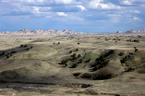 The Wall
These words, by artist E. de Girardin on a visit to South Dakota in 1849, summarize what most people imagine when they picture Badlands National Park. While it does beautifully paint a mental picture of part of the park it doesn't accurately describe all of the park. In fact, much of the land preserved within the park's boundaries consists of low, windswept ridges and buttes covered by prairie grasses, juniper, and a staggering variety of wildlife. While the rock spires are indeed awesome, the wilderness of Sage Creek, to me, includes the finest of what the Badlands has to offer. It is within the Sage Creek Wilderness that White Butte is located.
Rising to a humble 2,782', White Butte doesn't dominate any skylines...it's the location of this summit that sets it apart. Sitting 20 miles west of the jagged Badlands Wall and on the northern edge of the sweeping Sage Creek Wilderness one can simultaneously enjoy the sun lighting up distant rock spires over one shoulder while herds of buffalo graze the western high plains over the other. It's a truly amazing place...
Finding Where the Buffalo Roam...
 Badlands Wilderness
The Sage Creek Wilderness encompasses the western half of the northern unit of Badlands National Park. The most obvious and convenient jump-off point for a visit to White Butte or the surrounding wilderness is at Sage Creek Primitive Campground which sits off the Sage Creek Rim Road not far from the parks northwestern boundary.
The most direct route to Sage Creek Campground is by taking South Dakota Highway 240 south from Wall. Less than a mile past the Pinnacles Ranger Station the unpaved Sage Creek Rim Road diverges west from the main road. Sage Creek Primitive Campground is located 13 miles west along the rim road from this point.
From Sage Creek Campground the rest of the route is on foot. Though there are technically no maintained trails in this area, the local buffalo herds have created paths that rival the quality found in many other parks I've visited! Regardless, GET A GOOD MAP!
The most direct route involves following either bank of Sage Creek east from the campground. The river valley is broad here and the terrain is very easy going. After about a mile and a half you will reach a broad lowland filled with some good sized Cottonwoods. If you've been following the south bank this is a good place to cross the creek. Less than a quarter mile further east White Butte will show itself to the north. It's not hard to identify...though there are numerous hills in this area, White Butte's unique butte form gives it away.
From the creek bank it's up to you which route you want to pick to the summit, it only requires about a quarter mile walk and around 400' of elevation gain.
 White Butte NGS Topo: Image thanks to Bubba Suess
Summit Panorama's
  |
 |
 |
Red Tape - Access...
 Sage Creek Wilderness
As of 2011, entering Badlands National Park will cost you $11 to enter by vehicle or $7 by bike or on foot. That said, after visiting I did notice an absence of any ranger station entering the park by way of "Highway" 590 north of Scenic. I'm not saying you should cheat the system, I'm just saying...
In addition, the only road that accesses this area is the Sage Creek Rim Road. This is a dirt road that, most of the time, is quite well maintained. However, every brochure I've read states that conditions along the road can vary dramatically during the winter or during rainy periods. That said, it's probably a good idea to contact the park office if the weather has been, or is likely to be, disagreeable.
Camping & Wilderness Etiquette...
 Sage Creek Primitive Campground
As stated earlier the most convenient camping area is the Sage Creek Primitive Campground. Not only can you drive in but I was shocked to discover (at least as of 2011) it was free of charge for up to 10 days!!!
Of course, being that White Butte is located in a federally designated wilderness area, you can pretty much set up camp anywhere, permit free, with a few simple exceptions:
 Backcountry Camp
- No Fires (as you might expect, dry grass is very flammable...)
- No Pets (horses don't count...)
- Must be at least 0.5 miles from a trail or roadway and not be visible from a roadway.
- Practice good LNT!! (That's not a park rule, it's mine...if you can't follow it I strongly suggest checking out one of the fine hotel's in Wall...)
Some Useful Links...
 Sage Creek Valley
Badlands National Park - Official NPS site.
Badlands National Park Map - Trails Illustrated map of the Badlands. A useful map, though the 50' contours can be a bit deceiving...
TopoQuest - My go-to source for free topo maps.
White Butte Hike - Shameless self-promotion...the full album of my hike to White Butte.