
-
 54444 Hits
-
 75.51% Score
-
 7 Votes
|
|
Route |
|---|---|
|
|
40.02670°N / 105.649°W |
|
|
Hiking, Mountaineering, Scrambling |
|
|
Spring, Summer, Fall |
|
|
Half a day |
|
|
class 3 |
|
|
Overview

Please, don't leave me in the car
I adopted this site since it had no owner. Therefore, there is also an album about this adventure, which I created a long before adopting the route. It is a lovely traverse, and not very friendly for an aging dog, but Duchess did great. I will try to update this page as best as I can. Happy adventures!
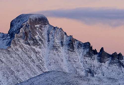
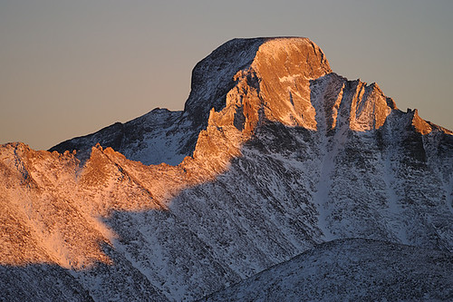
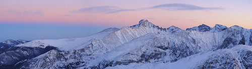
Arapahoe Traverse is a popular hiking/scrambling destination in the Indian Peak Wilderness. The hike to the South Arapahoe Peak from the Forth of July Campground via Arapahoe Glacier Trail is easy, class 1-2. The Traverse is scramble, and depending on your route finding skills, it can very from class 3 to low 5th class moves (very short, and truly mostly class 2 and 3). It is very scenic. The route is marked with paint at some sections, and there are some cairns, the biggest cairn is on the top of the North Arapahoe Peak.
Round Trip Distance: 8.3 miles
Round Trip Time: depends on your speed, if you run 4 hrs, enjoyable outing with breaks 8 hrs
Highest Elevation at North Arapahoe Peak: 13,502 feet
Elevation Gain: 3,500 feet
Length of the Traverse: 0.75 miles (check out the weather report, you don't want to be there during lighting).
Net Elevation Gain between South and North Arapaho: only 105 feet
Also, be aware that most of the route is above 13,000 get, so if you have problems with acclimatization to altitude, this may not be the best outing for you.
How To Get There

Arapaho Trail

South Arapaho Peak
The most common trailhead is the Fourth of July Trailhead, described in the main mountain page, and also below.
The trailhead is accessed by five miles of rough, 2 WD road. It is very popular and parking is limited, especially on weekends. Forth of July Trailhead provides access to Arapaho Pass, Diamond Lake, and Arapaho Glacier Trails.
There are vault toilets at the trailhead, and it is operated by U.S. Forest Service. The closest town is Nederland.
Directions from Nederland, head south on Colorado Highway 119 for 0.6 miles. Turn west onto County Road 130, signed for Eldora. Follow the paved road through the valley to the Town of Eldora, where the pavement ends. Continue beyond the end of pavement to the end of the road.
Day hiking permits are free. Overnight parking is 5$. Camping is prohibited in the trailhead. Pets should be on a leash.
Route Description

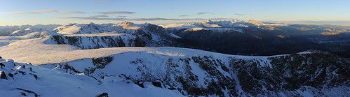
Arapaho Glacier

Crux of the Traverse
This well-travelled traverse ridge from South Arapaho is the easiest route to North Arapaho summit and one of the most popular Indian Peaks Classics.
from Gerry Roach's "Colorado's Indian Peaks classic hikes and climbs"
Begin by following the signed and well-beaten Arapaho Pass Trail for approximately 1.5 miles. At the Fourth of July Mine ruins (11,250'), double back to the northeast on the Arapaho Glacier Trail, which is also signed and well-beaten. After another 1.5 miles and 1500 feet of climbing, you reach the 12,700' saddle between South Arapaho Peak and Peak 13,038' to the east. From here, take in your first views of both the Arapaho Peaks, and the spectacular Arapaho Glacier.
From the saddle at 12,700', leave the Arapaho Glacier Trail and scramble the remaining 700' over class 2 boulders up the southeast slopes of South Arapaho Peak (13,400'). From the summit, follow the obvious connecting ridge to North Arapaho Peak. Start northwest from South Arapaho and descend slightly. The early going on this stretch of the ridge is straightforward. Choose your route carefully. If you see class 4 ahead, look even more carefully, and try to find an easier options. You will see use trails and cairns, some painted marks pointing your way. The easiest route along the ridge sometimes takes you off the crest of the ridge, over rotten rock with considerable exposure. And most importantly, don't forget to take in the spectacular views of Arapaho Glacier and other nearby features.
Continue north, staying on the ridge's west side. The exposure off the ridge's east side increases rapidly in this stretch. There is a small gendarme on the ridge containing the Class 3/4 crux. Scramble up to a small saddle on gendarme's south side and climb directly up a smooth and solid 10-foot, class 4 south face to the top of the gendarme. The crux is one or two tricky moves about 3/4 of the way to North Arapaho Peak, and there are good handholds there. You'll see an orange arrow spray painted onto the rock to aid your route-finding abilities. In some people's opinion, this short pitch makes the traverse a class 4 or maybe 5 climb. It is very short, and you even a fall would end up on a ledge. I don't think that rope is needed. I heard that you can bypass this section way below the ridge on the west side, but you need to drop pretty far low. I have not investigated this option.
Once you are north of the crux gendarme, stay on or west of the ridge and pass below two more gendarmes. At points you may be as much as 100 feet below the ridge, but seldom more than that. The remainder of the scramble is class 3, just follow the ridge. North Arapaho Peak has a huge cairn on its summit. The views are spectacular. Return the same way as you came in.
Essential Gear
A good pair of comfortable hiking boots. Warm clothing if weather changes, and rain gear.
I don't think rope is necessary, unless you have members in your party who are afraid of exposure - a short 25 meters rope should be sufficient in that case.
Winter: snowshoes for approach, crampons, ice axe, and probably rope.
Images from the previous owner
ColoradoScott - Aug 31, 2006 5:40 pm - Hasn't voted
Crux AlternativeThe ten foot slab crux of the traverse, is well beyong "Class III" in my opinion due to the lack of hand and footholds, in combination with the steepness of the pitch making the smearing option a tough climbing move for all but the tallest climbers that can reach the upper edge of the slab with their hands. I found an alternate way around this move, by heading east from the orange arrow about six feet and up a series of small solid rock shelves that I mantled and then proceeded aroung a small gendarme around the east side where passage to the top of the ten foot slab is gained thru a break in the ridge. This is still a serious "Class IV" move with significant exposure to the drop to Arapahoe Glacier well below. It is one of the hardest moves I would make when soloing (in dry conditions, only).
Liba Kopeckova - Jul 17, 2012 9:03 am - Voted 10/10
Re: Crux AlternativeI think it was not so bad, but I do love rock climbing. Had to even lift up my dog, and she did great. However, would not recommend to take a pet on this route.
andrewlryder - Sep 29, 2022 9:25 am - Hasn't voted
OptionsThe crux is like, 2 moves of low-angle slab climbing with limited exposure; if you have any climbing experience you likely won't think twice about it. There are footholds, don't worry if you're not tall. Overall there is not much difficult scrambling on the easiest route, lots of class 2 and easy class 3, but the position is nice and much of the rock is good. There is extra fun to be had if you want it.