
|
|
Area/Range |
|---|---|
|
|
51.88243°N / 3.43563°W |
|
|
Hiking, Mountaineering, Trad Climbing, Bouldering |
|
|
Spring, Summer, Fall, Winter |
|
|
2907 ft / 886 m |
|
|
Overview
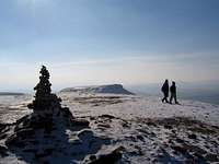
The Brecon Beacons (more properly called the Bannau Brycheiniog in Welsh) are a range of mountains in South Wales which are part of, and give their name to, The Brecon Beacons National Park. They are named after the ancient practice of lighting signal fires (beacons) on the mountains to warn of attacks by the English. They consist of a chain of peaks, roughly running from west to east, and have among them the highest peak in southern Britain, Pen y Fan, which reaches 886 metres above sea level. These summits form a long ridge which forms a horseshoe around the head of the Taf Fechan river to the south-east, with long parallel spurs extending to the north and north-east. The mountains owe their distinctive shape to their geology and are made of Devonian Old Red Sandstone. The range is relatively compact with the peaks generally within 1km of one another. Most visitors start their walk at the Storey Arms Visitor and Outdoor Centre (SN 983 203) which is located on the A470. From here Pen y Fan is only a short distance away and the route allows for the easy bagging of other nearby summits. The eastern part of the range is less visited, with fewer significant summits than in the west. A worthwhile route is a horseshoe that starts at the Talybont Valley carpark (SO 056 175) and follows the central ridge around to the west and then south along Craig Gwaun Taf and finishes by descending to the Neuadd Reservoir. On the ridge that connects Corn Du (SO 007 213) with Y Gyrn (SN 989 217) and Pen Milan (SN 995 234) there is an Obelisk (SO 001 218) that commemorates the death of Tommy Jones, a five-year-old boy who died on the mountain in august 1900. The son of a Rhondda miner, Tommy lost his way near Cwm Llwch Farmhouse while visiting his grandparents, starting a twenty-nine day search which aroused nationwide concern. His body was found by a Mr and Mrs Hamer of Cast Madog near Brecon at the spot marked by the obelisk. Tommy had died from exhaustion and exposure, but how a small boy managed to climb so high remains a mystery. The obelisk, a useful landmark in misty conditions, was paid for by the proceeds of a memorial fund started when the jurors at the boy’s inquest waived their fees.  The The Brecon Beacons (Photo by Nanuls) |
The Peaks
This table list the principle mountains that make up the range. Most are located on the distinctive central spine, however a few can be found further afield on the ends of the various ridges that radiate from its centre.
 Pen y Fan (Photo by DERWYN) Pen y Fan (Photo by DERWYN)
|
Geology
 The bedrock geology of South Wales The bedrock geology of South WalesThe geology of the Brecon Beacons is considered to be so special that its landscape is protected as a Site of Special Scientific Interest (SSSI). The SSSI covers 5009.95 hectares and covers all the ranges major summits as well as some land within the Fforest Fach area across the valley. The range is located on the northern edge of the South Wales Syncline and its bedrock geology is comprised of two main rock types. In the north, and for most of the range, the dominant rock type is Old Red Sandstone laid down under alluvial conditions during the Devonian (416-359 million years ago). This depositional regime was interrupted by periods of major uplift. In the early Carboniferous Period, limestones were deposited on a continental shelf which deepened towards the south where there was a major sea area. During this period earth movements caused by the approach of a continent from the south caused the swallowing of the sea which led to thick alluvial and coastal plain sediments being deposited which contain extensive developments of coal. This Carboniferous Limestone can be found extensively in the south where the landscape displays typical features of karstic terrain, including dolines, deep cave systems and limestone pavement. Outcrops of this limestone can be found throughout the National Park including on The Black Mountain, Fforest Fawr and Vale of Glamorgan. Outcrops can also be found as far away as Pembrokeshire and the Gower. During the Quaternary Period various ice ages caused the deepening and widening of valleys, the formation of cirque lakes, and the creation of moraines and other associated deposits. During the Late Devensian Stadial, the last ice age which ended around 12,000 years ago, the area was covered by a sheet of ice nearly 1,000m thick which covered even the highest summits. |
Wildlife and Conservation
This Brecon Beacons are an important example of the Old Red Sandstone uplands to be found in this part of Wales. The range contains mixed broadleaved woods in the lower sheltered valleys, a rich rock-ledge flora on the escarpments of the major corries and blanket bog and montane bent-fescue grassland on the summit ridges. The precipitous north-facing cliffs of Craig Cerrig-gleisiad (across the road), Craig Cwm-llwch, Craig Cwm-Sere, Graig Cwm Cynwyn and Craig Cwareli support a notable range of arctic-alpine plant species, here at or close to the southern-most edge of their range in Britain. Examples are purple saxifrage (Saxifraga oppositifolia), dwarf willow (Salix herbacea), serrated wintergreen (Orthilia secunda) and northern bedstraw (Galium boreale. Craig Cerrig-gleisiad, which is technically part of Fforest Fawr, supports at least 300 plant species, including 100 different bryophytes. Rock outcrops on Garn Fawr and Cwar y Gigfran provide a habitat for upland lichen species such as Pseudephebe pubescens and Umbilicaria cylindrical, both scarce species in southern Britain. |


Blanket bog, badly eroded in places, clothes the more gently sloping ridges. Apart from inaccessible ledges, frequently with a rich moss, fern and herb flora, the entire site is heavily grazed. Dwarf-shrub heath still survives in a few places, notably on Y Gyrn, Waun Lysiog and in Cwm Cwareli. Elsewhere it has been replaced by extensive stands of montane bent-fescue grassland with varying quantities of mat-grass (Nardus stricta). Wet flushes are frequent in the cwms and often support a notable flora, including bog orchid (Hammarbya paludosa). Herb-rich flushes are particularly well developed in the alder, ash and oak woodlands of the Nant Sere valley, which are also included in the site. Open water is scarce, Llyn-cwm-llych providing one of the few examples of a corrie lake in the area. Parts of the Brecon Beacons have been designated as a Special Conservation Area (SAC) and these areas are therefore strictly protected under the EC Habitats Directive. The Brecon Beacons SAC is split into three separate zones which combined cover 269.67 hectares and include within their boundaries the summits of Pen y Fan, Cribyn and Fan y Big.
 Brecon Beacons SAC Brecon Beacons SACAccording to the Joint Nature Conservation Committee (JNCC), who are the statutory adviser to Government on UK and international nature conservation, they are designated because the Old Red Sandstone cliffs of the Brecon Beacons support the most southerly representation of Calcareous rocky slopes with chasmophytic vegetation in the UK. The relatively high base-status of the actively eroding rocks has resulted in a chasmophytic flora which is comparatively rich for this southerly site. Species include purple saxifrage (Saxifraga oppositifolia) at its most southerly British location, green spleenwort (Asplenium viride), brittle bladder-fern (Cystopteris fragilis) and several rare (Hieracium spp). Nationally scarce bryophyte species include Plagiopus oederianus and Scapania aequiloba. The mountains also support Siliceous rocky slopes with chasmophytic vegetation on a number of cliffs and rock-faces. The more siliceous sites are often towards the top of the cliffs, where the calcareous cements have been leached out, with a transition to more calcareous chasmophytic vegetation lower down the face. Species found in this habitat include fir clubmoss Huperzia selago, serrated wintergreen Orthilia secunda and the nationally scarce bryophytes Brachydontium trichodes and Rhabdoweisia crenulata. General site character Bogs. Marshes. Water fringed vegetation. Fens (1.9%) Heath. Scrub. Maquis and garrigue. Phygrana (20.7%) Dry grassland. Steppes (52.9%) Inland rocks. Screes. Sands. Permanent snow and ice (24.5%) |
Mountain Activites


Rock ClimbingWhile there are plenty of limestone crags within and around the Brecon Beacons National Park, the Brecon Beacons themselves are less fruitful. Although the Old Red Sandstone cliffs make for spectacular mountain scenery, they do not lend themselves well to rock climbing, and therefore, largely ignored, and for good reason. If you would like to do some rock climbing in the area, it would be better to head south to somewhere like Dinas Rock in Upper Glyn Neath or east, to somewhere like Llangattock or Gilwern. To find out more about rock climbing in South Wales, see the South Wales Mountaineering Club’s Gower and S.E. Wales by Goi Ashmore and Roy Thomas and the club’s Guidebook Wiki. Winter Climbing
 RAC Corner RAC Corner(Photo by Nanuls) The north facing cwms of the Beacons may not offer anything in the way of rock climbing, but when the temperatures are low enough for snows to settle and the turf to freeze, they do afford a number of long and relatively straight forward winter lines. Grades range from Scottish I to III and take the alternate gullies and ribs along the north face of Pen y Fan. Those looking for pure ice route should look to the western and eastern extremities of the range. In the west Craig y Fro, also known as RAC Corner, offers a few of rather discontinuous routes at around Grade III/IV. They do have the advantage of being extremely accessible, as well as a burger van within close proximity. At the eastern edge of the range, one will find the isolated Torpantau Falls, which provides one superb icy route at around Grade III; possibly the best winter route in the Brecon Beacons. To find out more about winter climbing in South Wales, see the South Wales Mountaineering Club’s Guidebook Wiki and the South Wales Winter Blog. |
Mountain Conditions
This section displays the mountain conditions for Brecon Beacons. The information is provided by the Met Office and is issued twice per day. It is valid for the full 24 hour period on each day. Click on the widget for maps and further information. | This Brecon Beacons weather forecast is generated by the Met Office Weather Widget |
Mountain Rescue
Wales has fourteen Mountain Rescue Services, seven of which operate in the Beacons area. They are mostly staffed by local volunteers and funded primarily by public donations. They operate with the assistance of local Police, and in serious situations an RAF helicopter from RAF Valley. The West Wales Air Ambulance also helps out when necessary. The services work is not just restricted to mountain and wilderness rescue; often teams are utilised by the local police to search for missing or vulnerable persons in the community. The Mountain rescue services are:
 Pen y Fan (Photo by Attic Tony) Pen y Fan (Photo by Attic Tony)Brecon Mountain Rescue Team Central Beacons Western Beacons Longtown Mountain Rescue Team Severn Area Rescue Association West Brecon Cave Rescue Search and Rescue Dog Association In emergency situations Mountain rescue services can be contacted by ringing one of the UKs standard emergency service numbers: 999 or 112 |
Red Tape and Access
Unlike the national parks of North America and certain parts of Europe, there are no permits required for entry into the Brecon Beacons National Park, no visitor limits or any other kind of red tape designed to restrict access. Therefore, there are no significant red tape or access issues affecting the Brecon Beacons themselves. Since the passing of the Countryside and Rights of Way Act (CRoW) 2000, the public have the right to access almost all the land within the national park boundary regardless of ownership. Open access land is denoted by the signs below.
For climbers, hill walkers and mountaineers, the British Mountaineering Council (BMC) runs a Regional Access Database, which holds mountain/crag specific information on matters of conservation and access, including issues such as nesting restrictions, nature designations and preferred parking: If you are in any doubt about any particular access arrangement, or need to report an incident, you should contact your local BMC Access Representative or the BMC Access Officers for Wales: Elfyn Jones |


Getting There
Most walks start at the Storey Arms (SN 983 203) which is on the A 470 in-between Brecon in the north and Merthyr Tudful in the south. If coming from the south e.g. if you’re coming along the M4, take junction 32 (ST 142 816) near Cardiff and head north along the duel carriageway, the A470, to Merthyr Tudful. At Merthyr there is a roundabout which has four exits, take the second exit and stay on the A470, now longer a duel carriageway (SO 028 077), for around 10 miles to the carpark which is located on the opposite side of the Storey Arms. If coming from the north take the A438 from Hereford (SO 407 401) to the junction just after Bronllys (SO 144 350), and from here take the A470 to a roundabout junction (SO 067 278) with four exits. Take the second exit and drive west along the A40 to another roundabout junction (SO 032 284) and take the first exit south along the A470 to the Storey Arms. If you are parking at the Storey Arms make sure you lock your car and hide all valuables. Sometimes thieves come up from Merthyr Tudful and other nearby large towns and prey on the easy pickings that are often left in the carpark.  Pen y Fan, Cribyn and Corn Du (Photo by david howells) Pen y Fan, Cribyn and Corn Du (Photo by david howells)There are also car parks to the south of the range at Pontsticill Reservoir (SO 059 129), Pentwyn Reservoir (SO 054 143), Taf Fechan Forest (SO 042 163), Nant Bwrefwr Waterfalls (SO 056 176) and the Talybont Reservoir (SO 099 197). If coming from the south take the same route as the Storey Arms but take the third exit at the Merthyr roundabout, and drive a short distance east (only about 300m), and take a left followed by another junction where you drive straight ahead onto an unclassified road north towards the reservoirs of the Taf Fechan Valley. If coming from the north take the same route as the Storey Arms, but at the roundabout (SO 067 278) just east of Brecon, take left and travel east along the A40 for about a mile. After a mile turn left (SO 078 275), and left again driving under the A40,onto the A4558 and travel in a south easterly direction for 5 miles to Talybont on Usk (SO 112 228). From here turn right onto an unclassified road along the Talybont Reservoir to the carparks in the Talybont and Taf Fechan Valleys. |
Camping and Accommodation
There are numerous places to camp throughout the area, and there are several campsites in close proximity to the mountains themselves. The village of Libanus is very convenient for accessing the mountains as it is on the A 470 and a short distance away from the Storey Arms carpark. There are three campsites on nearby farms, one at Lower Cwmclyn (SN 987 253), one at Modrydd (SO 004 252) and one at Cwrt y Castell (SN 952 259). There are also campsites a little further away at Tyfry Farm Farm (SO 072 258) near Llanfrynach, Neaudd (SO 131 251) and Ty-Mawr (SO 126 260) near Llangasty and Pantllefrith Farm (SO 086 241) near Pencelli. For a full list of campsites in the Brecon Beacons National Park CLICK HERE and HERE
 Y Cribyn (Photo by Daveyboy) Y Cribyn (Photo by Daveyboy)There are also a number of Youth Hostels nearby two of which are ideally suited for the mountains being in close proximity to some of the main paths. In the west is the Llwyn Y Celyn Youth Hostel which is situated just off the A470. It’s a bit out of the way but is only a few miles down the road from the Storey Arms and only a stones through away from Craig Cerrig-Gleisiad, a designated SSSI and part of the Fforest Fawr GeoPark. At the eastern end of the range is the Danywenallt Youth Hostel which is ideally located for tackling the quieter regions of the mountains and is very close to some of the prettiest waterfalls in Britain. If you are looking for somewhere a little more central then the Brecon Youth Hostel is the best choice as it is located within the town and close to its shops, pubs and restaurants. If you are a large party there are a number of nearby bunkhouses available. Canal Barn, Cantref Bunkhouse, The Held Bunkhouse and Joe's Lodge Bunkhouse are all relatively close the Beacons and all offer what you would expect from such establishment. The most interesting bunkhouse in the area is probably the one at the Llangorse Multi-Activity Centre which has its own indoor climbing wall and bouldering room as well as offering a number of adventure based activities. |

