


Nelson - Nov 26, 2008 9:14 am - Voted 10/10
ChinookThe name of Rocky Mountain "Chinook" wind that you mention comes from an American Indian word meaning "snow-eater", which is also appropriate. The effect is not uncommon here along the Front Range of the Colorado Rockies. It brings a few glorious warm days in the middle of winter.

StarMan - Nov 26, 2008 9:16 am - Voted 10/10
Good article.This effect happens often in the southern Appalachian mountains of the USA. In winter, some very impressive snow totals occur on the upslope side of the northwest winds after a cold front passage... while the downslope side is dry... usually with sunshine.

Proterra - Nov 26, 2008 2:34 pm - Voted 10/10
A few things I miss...Winds always blow up and down mountains, but Foehn only occurs (and I guess, the people living in low-latitude valleys, say 25-40 degrees on both sides of the equator are very happy about this) in areas where the mountains are higher than the saturation point of the airmasses when it rises and cools down according to the dry adiabatic lapse rate.
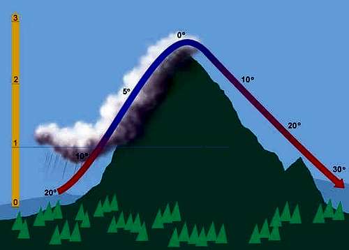
You posted a nice graph, which didn't explain the technical workings of it, so I'll give it a shot :-)
Say, it's 30C down on the foot, with a dewpoint of 12C and it needs to cross a 2000 metre range, there will be no Foehn on the other side. By the time the airmass reaches the summit, it will have cooled down to 10C with a dewpoint of 8C. If the same range is 3000 metres tall, it'll reach the saturation point at around 2350 metres, with a temperature and dewpoint of about 7.2C, and it'll start raining here, and the airmass will continue rising the last 650 metres by the moist adiabatic regime, to force remove moisture from the air and force the dewpoint down. When it reaches the summit, it's down to 4C for both dewpoint and temperature, resulting in 34C temps and 10C dewpoints on the leeward side, as opposed to 30/12C on the windward side.
If one goes further north into areas where the climate is more moist, and 15C temps with 10C dewpoints are common, and the airmasses need to cross the same 3000 metre range, (Say WA state for example, although they have a double foehn, and the Cascades are less pronounced - but the effect is pretty much the same.) the saturation point is reached much earlier. At 600 metres both dewpoints and temperatures are down to 9C, and everything starts rising moist adiabatic from here, resulting in -3C for both dewpoint and temperature at the summit, and 27C (81F) temps with 3C (37F) dewpoints in Yakima (= 20%RH), as opposed to 15C (59F) temps and 10C (50F) dewpoints in Quillayute (= 70%RH). Because Washington State is in the Marine west coast climate zone, these foehns here are part of the climate instead of a weather phenomenon, creating deserts outside of the Horse Latitudes.
Cheers,
Clint.

visentin - Nov 28, 2008 7:23 am - Hasn't voted
Re: A few things I miss...Thanks Proterra. I am convinced of the coherence of this technical addition, but I am afraid most of the common people are not able to read it. If you don't mind, I'll leave it here as a comment.

yatsek - Dec 15, 2008 6:00 am - Hasn't voted
Re: A few things I miss...Hope you don't mind me butting in. I get the feeling you're both right/wrong. Clint, as a scientist, tends to overcomplicate things a little bit while Eric, who majored in a different subject, has taken too much of a shortcut. I'd personally be for squashing Clint's to approx. 2/3
Cheers,
Jacek/Yatsek
visentin - Dec 15, 2008 7:26 am - Hasn't voted
Re: A few things I miss...You are completely right, I am not meteorologist, and despite I know few basics physics I wrote it to be read by anyone. Clint's explanation is probably right but perhaps it needs to be rewritten a bit more clearly.

bakcast - Dec 2, 2008 8:32 pm - Hasn't voted
Bridger MountainsI have seen this phenomenon many times on the leeward slopes of the Bridger Mountains in SW Montana - the clouds appear over the ridge creating a fascinating effect where the clouds bleed over the windward side of the range. As I recall it typically happens in the Spring and Fall and isn't aways present when we get Chinook winds. In fact, I don't think the winter Chinooks usually create the effect - only in Fall and Spring. I'll pay more attention to the time of year and snap a few photos next time. Thanks for posting!

BobSmith - Dec 7, 2008 10:47 pm - Voted 10/10
I recall...first encountering the term when I was taking German classes some years ago.

Diggler - Dec 10, 2008 11:48 am - Voted 10/10
Good articleIn particular, explaining how the winds come down hotter than they started. Thanks!
"Kriegt der Knecht vom Föhn einen Wahn, schlachtet er den Wetterhahn."- 'The farmhand that goes crazy because of (literally: gets a mania from) the Föhn kills the weathercock.'

distressbark - Jan 12, 2009 3:40 am - Hasn't voted
Glacier National ParkI lived in the Many Glacier region of Glacier NP this past summer, and had the pleasure of witnessing this effect firsthand on numerous instances. About 6 miles west of my residence is the Continental Divide, and we would often see storm clouds west of the divide that broke up as they came over Mount Gould, Swiftcurrent Mountain, and Mount Wilbur. Like your article describes, we'd see those clouds precipitously hanging atop the Divide, only for it to be warm and dry on our side of the valley. As expected, the west side of Glacier is wetter and slightly colder, with conditions in certain places such that there are actually patches of temperate rain forest within the park. The east side typically is warmer and drier.
Nice article. Thanks for the information.
visentin - Dec 6, 2010 7:50 am - Hasn't voted
Re: Glacier National ParkWith such a wide continent I am pretty sure you can observe enormous contrasts between both sides. Probably there is something kind of similar to our Atlantic gulf stream coming from your Pacific coast and bringing oceanic depressions on the West.
Without having been in USA, I can see on picture how much greener is the East side of the rockies, and I guess a huge foehn occurs on such high and long barrier. Perhaps it is less visible on one single ridge, as the thickness of the Rockies divide the effect in as many subranges.
ramram - Sep 5, 2013 8:53 am - Hasn't voted
SoaringAnother name associated with the Foehn effect is mountain wave. Soaring pilots use this to fly sailplanes to impressive altitudes, the record being upwards of 50,000feet! Here in the Northeast, autumn winds provide the ride to more moderate altitudes. Glider pilots from NY and Canada will be gathering in Lake Placid later this month to fly over the Adirondack Mountains. After several decades of climbing I took up the sport of soaring and hope to fly my sailplane higher than I've ever climbed. (Hint: I just bought an oxygen system.)
visentin - Sep 6, 2013 7:52 am - Hasn't voted
Re: SoaringYou are totally right, except perhaps for one detail, Foehn wind is a mountain wawe with bad weather on one side. Which in most of the cases probably does not allow safe soaring (clouds, low visibility...)
Without higher humidity on one side, the phenomenon of temperature increase on the other is less present, it becomes a simple effect is mountain wave but without Foehn :)
ramram - Sep 6, 2013 9:30 am - Hasn't voted
Re: SoaringRight you are! That's just one of the perils of flying in wave. With high humidity the clouds show where to go and where not to go. Stay away from the Foehn! Downwind from the Foehn there will be rows of clouds with open air in between them. The upwind side of these clouds will be rising air. The downwind side will be descending air. High lenticular clouds are an indication of mountain wave.
I find soaring to be very similar to climbing in that it is very mental; problem solving and decision making from the moment you start until you're down safe and sound. Clouds make up a lot of the scenery and you have to keep a close eye on the weather. And it's basically the same people, just a little older and maybe not in as good shape as climbers.
Comments
Post a Comment