
|
|
Route |
|---|---|
|
|
34.62720°N / 84.1936°W |
|
|
Hike |
|
|
Less than two hours |
|
|
Class 1 Walk-up |
|
|
Approach
Start from the FS 42 trailhead at Big Stamp Gap (3,350 feet). See main page.
This is the nearest road access to Springer.
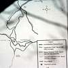 |
Route Description
From the trailhead only .9 miles separates the hiker from the wooded summit of Springer Mountain. It is an easy and quick hike through forest to the summit. There really isn't much more to say!
Essential Gear
Standard hiking gear is all that is necessary. In winter perhaps snowshoes or ice cleats would be helpful. Check the local weather conditions.
Miscellaneous Info
If you have information about this route that doesn't pertain to any of the other sections, please add it here.