
-
 4399 Hits
-
 73.06% Score
-
 3 Votes
|
|
Route |
|---|---|
|
|
47.41525°N / 11.71117°E |
|
|
Hiking |
|
|
Spring, Summer, Fall |
|
|
Most of a day |
|
|
not a difficult hike |
|
|
Overview
 Bärenkopf summit (02-11-2008)
Bärenkopf is the easternmost summit of Karwendel. Its altitude is not outstanding in comparision to the main Karwendel peaks but it stands alone as a summit and offers very nice views so I think it is worth while mentioning - and climbing.
Bärenkopf is the highest point of a secondary ridge of the Rappenspitze - Stanser Joch ridge, the easternmost subgroup of the Karwendel mountains. The ridges are connected by Weißenbachsattel (1693 m), an important traverse in this subgroup. Bärenkopf is northeast of this saddle.
Bärenkopf stands south of Achensee, the fjord-like lake above Stans / Inn valley. Maurach and Pertisau are the main villages in the Achensee valley and there are also the trailheads for Bärenkopf.
Getting There
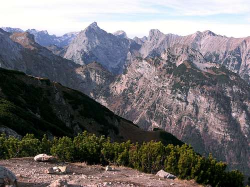 Sonnjoch and adjacent Karwendel summits as seen from Bärenkopf ascent (02-11-2008)
There are two trailheads which can be used as a start and end point of a very satisfiing loop.
Head to Maurach as indicated om the Bärenkopf mountain side.
At Maurach / Rofan cableway follow the road to Pertisau.
You reach the first trailhead if you take the first road left after the traffic circle. It crosses the railways and goes strait to Maurach - Lärchenwiese. At the end of the paved road there are some possibilities to park the car. The road goes on into Weißenbachtal, its a forest dirt road closed to traffic.
The second trailhead is at the Zwölferkopf cableway at Pertisau. There is a huge parking area, I think you have to pay. If so, do it :-)
Route Description
 Bärenkopf ascent view to the northwest (02-11-2008)
Route from the first trailhead (950 m):
Follow the forest road into Weißenbachtal. The road gains hight and after several switchbacks you arrive at the private Weißenbachhütte at the beginning of Weißenbach Alm meadow. You pass Weißenbachalm, a nice Alm hut which provides food and drinking for hikers during summer times. The forest road reaches at last Weißenbachsattel (1693 m). The forest road descents to Bärenbad Alm and to Pertisau and reaches the second trailhead.
Route from the second trailhead (940 m):
To the south of the parking area of the second trainhead stands Zwölferkopf, which can be reached by cableway from Pertisau. Take the forest road, which heads some 200 m west of the cableway station south up Zwölferkopf. Leave the forest road after its first switchback and use the trail right of the road. This trail, traversing the forest road one more time, heads up the north and later the east slopes of Zwölferkopf. Further up you follow part of one of the downhill ski slopes of Zwölferkopf cableway. Finally you reach Bärenbad Alm restaurant (1457 m).
At Bärenbad Alm you reach the forest road again. Use the forest road up to Weißenbachsattel.
 Bärenkopf summit meadows (02-11-2008)
At Weißenbachsattel a sign indicates the direction to Bärenkopf, yet visible to the northeast.
The trail climbs a broad meadow ridge, called "Am Filz" and after loosing some height it climbes very steep up to "Bärenhalsl". There is a trail junction with a shortcut trail directly coming up from Bärenbad Alm.
After the junction the trail continues steeply upwards gaining the south side of Bärenkopf and traversing through some interesting rock formations. Finally you reach the summit meadows.
The summit cross stands on the eastern part of the summit plateau.
There are some marvellous views from Bärenkopf, especially the view of Lake Achensee to the north and the Karwendel peaks to the west an northwest are worth while.
Essential Gear
 Achensee as seen from the summit (02-11-2008)
Normal hiking gear and hiking shoes.
In spring there might be still snow, so think about bringing gaiters.
In late autumn the Alm huts are closed so bring all your necessary food with you. Trails might be icy then.
Books & Maps
The best ones are:Alpenvereinskarte 1 : 25.000, Blatt Nr. 5/3, Karwendelgebirge, Östliches Blatt;
Walter Klier: Karwendel alpin, Alpenvereinsführer, Bergverlag Rother
Trail Options
[img:474961:alignleft:medium:Achensee as seen from the summit (02-11-2008)]As Bärenkopf is not a very demanding hike for good hikers there is one good option for an additional summit: Stanser Joch:
Return to Weißenbach Sattel and follow the signs indicating Stanser Joch. Follow the north slope trail up to "Am Übergang". To the west you can climb Ochsenjoch easily, to the east there is the summit cross of Stanser Joch waiting. Return to Weißenbachsattel and to your chosen trailhead.
Alternatively, you can finish your hike following the Stanser Joch east loop, which can be highly recommended if you started from the first trailhead at Maurach or you do the Stanser Joch - Ochsenkopf - west loop, which is a very long hike for one day and you should start it from the second trailhead. Nevertheless this western loop is the most interesting traverse through this easternmost Karwendel subgroup.