
-
 6802 Hits
-
 81.84% Score
-
 14 Votes
|
|
Mountain/Rock |
|---|---|
|
|
43.86910°N / 109.2821°W |
|
|
Park |
|
|
Hiking |
|
|
Summer, Fall |
|
|
10536 ft / 3211 m |
|
|
Overview and Climbing Information
 Mount Crosby from the top of Bald Mountain
 Kirwin below Bald Mountain with Spar Mountain in the background
Bald Mountain is really just a hill on the north flank of Spar Mountain and sits less than a mile southeast of the ghost town of Kirwin, WY. Sitting almost completely surrounded by spectacular 12,000-foot peaks, it is a very plain and uninspiring mountain to view. However, if you are traveling to this area on a day trip and don't have time to take a substantial hike anywhere, this would be a wonderful mountain to climb, as it is a very easy walk-up that takes about an hour; the views of the Kirwin Valley and the mountains in the area from the top are absolutely stunning.
 View from Greybull Pass
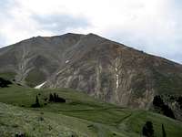 Spar Mountain
 Cabin on Bald Mountain
 Copper Mine
Start your hike at the west end of the Kirwin parking areas where the locked gate shuts off the road that becomes the East Fork Trail; cross over the Wood River (no more than a large creek at this point) on the wooden footbridge and head over to the town of Kirwin, where the remaining buildings from this century-old mining town are open to see and explore. Bring a flashlight if you want to see inside most of them, as a lot of the rooms are totally dark. Stay on the main road and bypass Kirwin on your left to start up onto the mountain. The road is wide enough for a fairly large truck, but it has been closed off for a number of years; there are several trees that have fallen across the road, but these are not hard to get over. There is also one point where a stream crosses the road, but it's not very wide unless there has been a lot of recent rain. The are several side roads that branch off the main one, but these are starting to be overgrown with young pine trees, so it's probably best to stay on the main road.
After about a mile of lengthy switchbacks and about 1,000 ft. of elevation gain, you will find yourself above the treeline. There are several mines and remains of cabins off the trail on the right side, and the mountain views are amazing. The main road starts to disappear, but as you can see if you look closely at the main image for this page, there are dozens of trails and old roads up on top above the treeline. The quickest way to the top is to do a little Class 2 scrambling up from road to road starting around the second old cabin below and right of the trail, and it is often possible to follow each road up for a little ways before you see another one a little higher up. If you're looking for something less strenuous, it's also possible to stay on a Class 1 trail all of the way up to the ridge in back of the mountain that connects the top of Bald Mountain to the North ridge of Spar Mountain. Once on top of the ridge, turn left and you will find yourself on the large plateau that makes up the summit area.
Hiking to the top of Bald Mountain takes around 60-90 minutes from Kirwin. This hike covers over 1,300 of elevation gain and about 1.5 to 2 miles of ground depending on if you go around on the easier trail or start going straight up once you're out of the trees. My wife and I made it above the treeline at 10,200 ft. hiking really fast in about 30 minutes our first time on this mountain, but we were on a tight schedule and had to start right back down again before we got to the top. During our second trip up this mountain we were carrying packs and made the top in just over an hour.
 Bryan Mine on Spar Mountain
 Brown Mountain from the top of Bald Mountain
Once on top, you will have outstanding close-up views of Spar Mountain to the south, Mineral Mountain to the east, and Dundee Mountain to the northeast. Cascade Creek runs between Spar and Mount Sniffel, the mountain to the southwest whose rocky face looms over Kirwin. Across the valley Mount Crosby dominates the eastern skyline, and Dollar Mountain and other 12,000 footers are seen in the distance to the left of Crosby. Brown Mountain is separated from Crosby by Brown Basin and Greybull Pass, and Chief Mountain is seen looking north back down the valley. Also look for the Bryan Mine at the base of Spar Mountain; the amazing view from here is well worth the short hike!
 Mount Sniffel from the top of Bald Mountain
Getting There
You will have to drive to the Kirwin trailhead. 4WD is recommended, but high clearance and AWD will suffice under most warm-weather conditions. Kirwin was a mining boomtown many years ago, and several structures still remain in the area. The ruined townsite is a popular destination for locals who like to drive up for lunch and a tour, but few people outside the area know anything about Kirwin and the awesome trail system it accesses. Kirwin is also one of the most beautiful trailheads in the Rockies, with towering, brooding mountains all around it. Kirwin
 Wolf Creek Mine
From Meeteetse, 32 miles south of Cody, turn west onto the signed road for Wyoming 290. In 6.4 miles, turn left onto Wood River Road. At 11.6 miles, the pavement ends. The national forest boundary is at 21.7 miles. Pass Wood River Campground at 22.4 miles and Brown Mountain Campground at 24.8 miles. The road now gets a little rougher, but it is not real 4WD stuff. At 26.8 miles is the first of four stream crossings. This one is short and usually shallow. The second river crossing is at 27 miles. This one is wider and deeper. The third crossing, which is actually two crossings in quick succession, is at 29.3 miles. These are broad but shallow. The last two miles to the trailhead are rocky but not anything to get nervous about. There is one more stream crossing just before the trailhead, but it is a tributary stream and may even be dry. The trailhead is at 33.1 miles. It took me 75 minutes to make the drive.
Directions above used with permission from Bob Sihler's Kirwin page.
There are two roads that lead through the longest river crossing. When heading to Kirwin it is hard to find the left fork, so you shouldn't have a problem staying right; in the summer of 2008 there were pink ribbons tied to stakes and trees marking the route through the water. On the way back out, stay to the left in the trees when you reach the fork unless you want to spend a lot of time driving in the water and trying to figure out where the road goes.
Pay close attention to recent weather before going to Kirwin, as rain and spring runoff can make the crossings very interesting. My wife and her parents were up there in June 2005 in a Jeep Cherokee that left the ground and floated for a few moments during an afternoon crossing in the middle of spring runoff!
Red Tape
There are no permits required to hike in this area; the Meeteetse Ranger District can be reached at 307-868-2379 for any questions on access.There are grizzlies in this area, so beware! My wife and I saw dozens of tracks and claw marks eleven feet up on tree trunks during our two days of hiking around Kirwin. Carry bear spray at all times and know how to use it; you should practice getting ready to spray quickly, as a bear charge can happen lightning fast. Make as much noise as possible, especially when you're on a trail in the trees.