
-
 20502 Hits
-
 91.75% Score
-
 36 Votes
|
|
Mountain/Rock |
|---|---|
|
|
44.60727°N / 109.61049°W |
|
|
Mountaineering, Scrambling |
|
|
Summer |
|
|
12216 ft / 3723 m |
|
|
Overview and Route Information

Anyone who has driven the Beartooth Highway has probably seen Dead Indian Peak. Away to the south in the Absaroka Range, it juts up from the rest of the peaks and is one of the most distinctive summits in Greater Yellowstone. Were it closer to the highway, it might even vie with the profile of Pilot Peak, which, for my money, is the most impressive major spire-like peak in Greater Yellowstone, even more so than the Grand Teton.
Regardless, Dead Indian Peak, part of the very rugged North Absaroka Wilderness, is spectacular from any vantage point, and it is easy to see why it fires the mountaineering lust. But it is no small matter to get there. The easiest routes, terrain-wise, are in excess of 20 miles one-way. The shortest and most commonly used routes, which reduce the one-way distance to under 10 miles, are punishing.
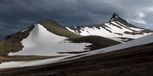
The third-highest peak in the Northern Absaroka Range after Trout Peak and Mount Dewey, Dead Indian Peak (or perhaps Pilot Peak) might be its icon, perhaps challenged by the snowy masses of Sunlight Peak and Stinkingwater Peak (the latter name derives from legendary mountain man John Colter's name for the Shoshone River). Dead Indian's small summit is deep in the wilderness and yields views of more untrammeled wilderness in all directions. The breccia summit is capped by a layer of andesite that makes the top, in appearance, truly live up to the "summit nipple" moniker.
The Name, Early Climbs
Although locals had already been referring to Dead Indian Peak by its current name, the peak was called "Devil's Chimney" by a geologist named Thomas Jaggar after an 1893 visit, but when topographer Frank Tweedy created a quadrangle published in 1896, he used "Dead Indian Peak," and so the name has stayed to this day. 1953 saw the first recorded ascent, by Thomas J. O'Brien, leader of a USGS survey party, but Thomas Turiano, author of Select Peaks of Greater Yellowstone, believes that Native Americans, early ranchers, and Tweedy probably climbed the peak before that. (The source for the information in this paragraph is Turiano's book.)
Dead Indian this, Dead Indian that. What gives?
Dead Indian Peak. Dead Indian Hill. Dead Indian Pass. Dead Indian Meadows. Dead Indian Creek.
They are all out there, all in more or less the same vicinity. So what's the story?
"Dead Indian" refers to something that happened at the pass. Later, the name "spread" to the other landscape features.
There are at least three stories. It is easy to learn about them by googling; there is also an interpretive sign at the pass explaining the first story.
#1-- In 1878 during the Nez Perce War, the Nez Perce left behind a wounded warrior at the pass as they sought to escape the U.S. Army. The next day, Crow scouts serving the army found the warrior and killed and scalped him, and then they buried the body beneath a pile of rocks.
#2-- In 1877, Chief Joseph, fleeing from the army and attempting to escape to Canada, left the body of a killed Indian as a ruse.
#3-- Prospectors, wanting to signal their intent to explore the area, killed an Indian and propped his body up as a warning to others.
 Nez Perce War... Nez Perce War... |
 |
 |
 |
The Route
Elevation gain from trailhead to summit is about 5000', but the true elevation gain, after ups and downs and likely a different starting point, is closer to 5500-6000'.
First, the good news: if you have been reading Turiano's guide, you can dispense with the idea that the one-way distance is 12 miles; it is 7-9 depending upon the exact approach you take from Gravelbar Creek. But, as will be noted below, you may have to add up to 1.5 mi to the route each way.
And now the bad news: there are some problems with Turiano's description. This trip report lists them; the rest of this route description will point out and correct those problems along the way.
Also, I do not mean to seem to be trashing Turiano's work. His book is a great resource and I highly recommend it, and many of his route descriptions are excellent; it is just that the one for Dead Indian has some flaws.
On to it...
You may not actually start from Gravelbar Creek as the route description states. To get to the end of the road at the creek, you have to cross Sunlight Creek. In July and August of successive years, the stream was impassable for all but the highest-clearance high-clearance vehicles. This means fording the stream on foot (maybe not a great idea if a vehicle can't cross it) or driving a tenth of a mile up Sunlight Creek Road, parking in a public site, crossing a bridge to a ranch gate, and then hiking the fenceline until branching out to reach the road to Gravelbar Creek. Add anywhere from 1.2-1.5 mi each way if you have to do this.
At Gravelbar Creek, cross the stream and pick up a good trail not shown on Forest Service Maps or USGS quads. Turiano says to hike the trail for "some distance" and then climb a ridge to "the main ridge separating Sunlight Basin from Dead Indian Creek...[which] leads easily for over 2 miles to Dead Indian's summit nipple."
 The kind of stuff you're in for on the spurs... The kind of stuff you're in for on the spurs... |
 |
 |
(Photos above by musicman82)
There are many spur ridges leading to the main ridge above from Gravelbar Creek. If one of them is supposed to be the one and only, it is not apparent at all. A map diagram in Turiano's book suggests that the spur he means is the one leading to the junction of the ridge leading west from Elkhorn Peak and the one leading north from Dead Indian; in other words, you are aiming for the corner. However, the "over 2 miles" is more like this: the actual distance from that point to the summit is almost 4 miles (3.7 by my GPS).
Also, what the book calls and what a picture suggests is the North Ridge is not it at all; it is rather a northeastern ridge, and while climbing it is not impossible, it has outcrops and pinnacles that would considerably slow you down were you to gain it from Gravelbar Creek. It is clear from a photo that Turiano gained this ridge, not the one accessed from Gravelbar Creek. This is not going to get you into trouble, though, unless you have ascended from somewhere else, plan to descend via Gravelbar Creek, and are utterly incompetent at reading the land and reading a map.
The ridge you will reach from Gravelbar Creek is the true north ridge.
Now for my details, and enough with dwelling on the guidebook...
 Spurs... Spurs... |
 |
Let's start with saying that I have now been up or down four different spurs that access the ridge leading to Dead Indian's summit. I am going to discuss the one that, of the four, seems to be the best, but let me be clear that not one of the spurs is pleasant; each involves difficult bushwhacking, difficult scrambling, or both.
Based on my reading of Turiano's diagram and my observations from a failed attempt in 2010, I decided that the spur leading to the "corner" already mentioned was the way to go. For quite a while, as I frequently found and followed a good trail up the ridge, I thought I was right, but things got much worse around where the trees started to peter out. It's hard to think that the way I went can be the "standard" route, but it worked and, as I said, seemed to be the best of the four I've used, so that's what you get here. But just about any spur should work; it's just that distance and difficulty will vary.
Along the trail, there are two notable rises. One is fairly small and drops just as quickly, but the second is more significant. The crest begins at about 1.4 mi from the crossing of Gravelbar Creek. Leave the trail here-- around elevation 7600'-- to gain and follow the semi-open ridgeline. This does involve some ups and downs, but the bushwhacking is not bad and there is often a trail to follow.
Note-- because the trail is not shown on the map, I cannot guarantee that my diagram shows the exact location where I left to gain the ridge. However, it was definitely atop that second rise and just before the trail began making a sharp descent to Gravelbar Creek. The GPS coordinates for the point are N 44 40.258', W 109 36.304'.
Another note-- another arm of this ridge departs from the trail closer to the Gravelbar Creek crossing and seems better. SP member musicman82 descended that way and confirmed that it is better-- gentler and more open.
And another-- The next spur south seems better as well, but it has some difficulties up high, including a large gendarme that looks too difficult to climb and hard to bypass. Also, reaching it means dropping to Gravelbar Creek first, adding elevation gain to your route both ways. This spur joins "my" ridge near the top.
 |
 |
As the trees thin, you reach a series of gendarmes and outcrops. They tend to be easy to climb but difficult to descend, forcing Class 4/5 downclimbing or backtracking in search of a bypass. Where the spur reaches massive cliffs, the better option seems to be to stay to the left and traverse steep, loose talus while gradually following the path of least resistance (Class 3 overall but very steep and loose). Eventually, I regained the crest of the ridge and then found a sheep trail leading across the talus and ending below a short, loose scramble that gained the ridge above at almost 10,800', in a broad saddle between Point 10,824T and Point 10,763T. This point is about 2.5 miles from the trail, 4 from Gravelbar Creek.
 |
 |
 |
From this point, pretty much "the corner" (I might call Point 10,824T the corner itself), it is 3.7 miles to the summit of Dead Indian Peak. If you follow the ridge itself, the distance will be a little longer and the elevation gain more due to peaks along the ridge; my choice was to, as much as possible, contour across the tundra basin below the ridge.
If you do contour across the basin, be aware that there may be several marshy areas. For the sake of your dry feet but especially for the sake of this pristine area, please do your best to go around the marshy areas or stick to large, solid rocks as much as possible if you do have to cross the marshy areas.
 |
 |
The last 0.4 mi to the summit block hurts. Elevation gain is about 600', not the worst ever in that distance, but it is up loose scree and is painful after all the exertion of the approach.
 |
 |
The summit block itself is easier to climb than it looks from a distance. It's Class 3 scrambling, and exposure is not an issue. Turiano warns about the "colossal" exposure on the east and west faces, but that is not a factor when scrambling to the summit, and the rock is pretty good for the Absarokas. He says that "an ascent of Dead Indian should not be taken lightly" and implies that is due to the exposure and the loose rock; I would caution not to take it lightly because of the difficult approach, the distance from help, and the several miles of exposure to storms that the route entails.
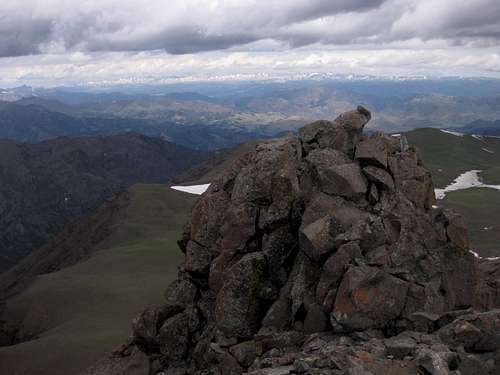
At the summit are a broken benchmark and a register tube; perhaps I need to use steroids or learn how to unscrew a register tube, but I could not open the tube when I was there!
Remember: Since it is unlikely that you will be able to drive across Sunlight Creek unless it is late August or early September or an extraordinarily dry year, your one-way distance is going to be 8.5-10.5 miles with a total elevation gain of around 5500-6000'. Backpacking is unpleasant due to the difficulty of the spurs. A day climb means a very long day for most people. So no, an ascent of Dead Indian should not be taken lightly.
Other Routes
Along Sunlight Creek Road, there are two trailheads signed for Dead Indian Meadows. One trail is 12 miles and the other is 14 (one-way distance). Dead Indian Peak is still several miles from the meadows, and the total one-way distance appears to exceed 20. Obviously, the distance is a major drawback, but the travel is much easier. This might be a good option for someone using upper Dead Indian Creek as a base from which to climb Dead Indian Peak and other peaks in the vicinity, but it's not so great if the sole objective is Dead Indian Peak.On his website, Turiano has mentioned learning about legal access from the North Fork of the Shoshone River, specifically via a trail following the drainage of Big Creek, but he does not know any details about the route. If you know anything, please share it here and there. It would be a very long route.
People have also approached via the route for Trout Peak (see link in Overview). This, too, would be a very long route.
Some people have done all or part of a traverse including Trout Peak, Mount Dewey, Dead Indian Peak, and Elkhorn Peak (the full route is over 30 miles and has more than 10,000' of elevation gain). The ridge traverse between Dewey and Dead Indian in rumored to be Class 4 or harder, exposed, and loose. Below are two pictures showing the traverse.
 Seen from the north Seen from the north |
 Seen from Dead Indian Seen from Dead Indian |
Getting There
 Along the way...
From WY 296 turn onto the signed road following Sunlight Creek into Sunlight Basin. This road is between Dead Indian Pass and Sunlight Bridge and is actually just before Sunlight Bridge if one is approaching from Dead Indian Pass, and just after it if one is approaching from the Beartooth Highway.
Drive about 13 miles and then turn left onto FR 182. This road is not signed at its beginning, but there is a sign shortly along it. The road drops immediately to Sunlight Creek and crosses it. If the stream is low enough to cross with a vehicle, do so and drive a little over a mile to its end at Gravelbar Creek. The road is rocky but should not be difficult to drive in a high-clearance vehicle.
If the stream is too high to cross, and it probably will be so until mid-August most years, then drive a tenth of a mile up Sunlight Creek Road, parking in a public site, crossing a bridge to a ranch gate, and then hiking the fenceline until branching out to reach the road to Gravelbar Creek. Remember that you will add anywhere from 1.2-1.5 mi each way to your route if you have to do this.

Red Tape
It's prime grizzly country, and the off-trail travel through wooded terrain heightens the chance of a surprise encounter. Make noise, carry pepper spray and have it accessible at all times, and know how to behave around the bears.The following acts are prohibited in the North Absaroka Wilderness:
Camping within (50) feet of any trail.
Grazing livestock at sites posted as closed to livestock grazing.
Using a campsite or other area with a group exceeding (20) persons and or a combined number of pack and saddle stock exceeding (30) animals.
Possessing, storing, or transporting food for livestock except for pelletized feed or processed grain (rolled). Cubed hay is authorized only if certified weed seed free by an authorized Federal, State, or County Officer.
Camping or otherwise occupying a single location for a period exceeding (16) consecutive days.
Leaving camping equipment unattended for a period greater than 48 hours.
Camping
There is no campground, but you can camp at the crossing of Sunlight Creek, Gravelbar Creek, along the trail, or at a dispersed site along the main road. Off-trail backpacking out here, which I've done before, is not recommended unless you want to suffer. If you do, though, the high meadows near the peak make wonderful campsites (see picture).