
|
|
Route |
|---|---|
|
|
35.52000°N / 76.30000°E |
|
|
Hiking, Mountaineering, Bouldering, Ice Climbing, Big Wall, Mixed, Skiing |
|
|
Spring, Summer, Winter |
|
|
Expedition |
|
|
BALTORO-CONCORDIA- K2 BASE CAMP TRAIL:
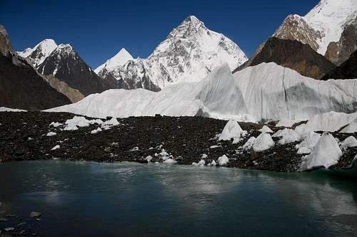
This route has the status of being one of the most magnificent in the world. It goes up to the massive Baltoro Glacier which cuts through most impressive concentration of high mountains in Karakoram, up to Concordia at the crossroads with the K2 Glacier (Godwin Austin Glacier) in breathtaking setting of 8000m mountains. K2 from Concordia
This route is strenuous, complicated, rougher, only those who are physically fit and expert can undertake this venture. Although it is a frequented trek and there is no lengthy vertical ascents. It involves crossing many streams and icy glaciers. This route lies in specified restricted zone and permit is required from Government of Pakistan. The usual day-stages from Askole to Concordia, are nine. The porters wages and their food, insurance, fuel, kit/equipment and shelters are fixed as per Government of Mountaineering/Trekking Rules & Regulations in Pakistan.
 K-2
K-2 Getting There
 Journey to the Mountains
 Askole (3048m)
At Askole you have camp. The camping sites are available in Askole village and a camping fee is payable her depending on the size of the tents. Here you have to hire porters.
Route Description
The route beyond Askole enters the region of “The Greatest Museum of Shapes and Forms” as described by Fosco Maraini. The trek crosses unevenly over the dangerous moraine of the Biafo Glacier where it gathers Braldu Valley. Baltoro Glacier
 From Askole to Burdumal
From Burdumal (3353m), the trail is quite easy. The valley broaden and the trail ascend wide slopes from where one has the first views of Baltoro Glacier snout which is rock spotted, ugly and grey. Downward a little and following the Biaho Lunghpa, one can reach Payu (3368m). In Balti the Payu means Salt. This is traditional halt for porters and rest day. Here one has to stay in tent for overnight. The distance between Burdumal-Payu is about 15 kilometers.
 Payu Camp Site
After Payu, in the broadening valley the highest peaks of the Karakoram start coming into view. The trek enters in a zone of frozen wilderness where the storm throws glacier is seen covered with unstable rocks. Hiking continuing further beside the northern side of the glacier over hillocks and broad stretches of stones. The glacier snout is about 2 km wide, rounded northeast and then east on the long route from its head at Concordia. Trekking on the glacier will slow and strenuous and one has make the additional endeavor to find a safe route., keeping away from crevasses and ridges. After a tiring hike, one can reach Liligo (3715m), a nice and wonderful camping ground surrounded by the high peaks. Distance between Payu and Liligo is 10 kilometers.
 Baltoro Glacier
 Crevasses at Baltoro Glacier
From Liligo (3715m), the most strenuous part of the whole trail starts. In involves crossing several of the side glaciers coming in from the north between great rock peaks, trekking up and down over puzzlement of rocks and threading a way in a never-ending network of gigantic boulders. To the left high snow capped mountains and great rock towers stab the sky. After a tiring hike, one can reach to Urdokas (4011m), which means fallen stones in Balti language. The Urdukokas camp site is 300 meter is situated 300m above the glacier, and a broad grassy slope. Many boulders can be found dotted around the camp. The distance between Liligo camp site to Urdokas is 10 kilometers.
After Urdokas, another strenuous hike over sonw and moraine hillocks of freezing icy rocks. Hiking on glacier, sometimes the snow tuned soft and one can sinks knee deep in to glacier. After a strenuous and tiring hike, one can reach the Goro campsite (4345m). The distance between Urdokas to Goro is 12 kilometers.
From Goro to Concordia, it takes about 4 to 5 hours to reach Concordia. All the way there are spectacular views of 7000 and 8000 peaks. “Concordia” was named by Sir Martin Conway. Here, the K2 (8611m) the second highest mountain in the world, and its foot stretches one more wonder of the world, Concordia, a flowing, uneven, pockmarked river of snow, where great glacier slide and slither together before separating to go their there own ways. Like a proscenium, Concordia is part of the main stage of natural amphitheatre that has no equal. From Concordia, on all side, within a distance of 24 kilometers, rise up ten of worlds thirty highest mountains.
Here at Concordia, one can stay for hiking to K2 base camp, Broad Peak Base camp, Gasherbrum Base camp or for further trekking to famous Gondogoro la or back to same route to Askole and Skardu.