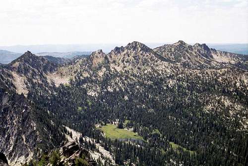
Gunsite Mountain, Angell Peak, Lees Peak, Pk 8,525
![Left to right: Pk 8,538,...]() The Anthony Lake area peaks form the abrupt north terminus of the Elkhorns. Left to right: Pk 8,538, Angell Peak, Lees Peak, The Lakes Lookout.
The Anthony Lake area peaks form the abrupt north terminus of the Elkhorns. Left to right: Pk 8,538, Angell Peak, Lees Peak, The Lakes Lookout.![The northwest side of Pk 8525...]() Pk 8525
Pk 8525![The steep northeast face of...]() Lees Peak
Lees Peak
I don’t know where I have been. My in-laws, who we visit a few times a year live at the foot of the Elkhorn Mountains, the highest subrange of the Blue Mountains, and after many years of going down there I had never climbed a peak in them. I had entered the mountains on several occasions, but never sought out a summit. I would have to repent and make up for it. This trip would not only get me a good start on that, but would get me away from the in-laws for a whole day.
The Anthony Lake area is typically very busy, but I was early enough that the crowds hadn’t arrived yet and the campers were quite in their tents. My plan for the day was to hike up the west ridge of Gunsight Mountain to the summit then hike down the southwest slope or continue around the ridge to Angell Peak. I started hiking along the lake shore and on up toward Hoffer Lakes and right away was reminded of how horrid the mosquitoes are here, but while walking fast, I kept ahead of them. Soon I was at Hoffer Lakes and picked my way around the bogs and swamps on the east side to the foot of the mountain where I decided to start up.
Gunsight is a straightforward mountain with straight slopes up the southeast aspect and variable rocks directly up the west ridge. Around the aspect to the north the granite becomes vertical. A scramble up the ridge allows one to vary from easy slopes to difficult rocks and anything in between as they go, which made for a fun and challenging hike through the dense tangled whitebark pine. The day seemed like it would be a nice one but it was still early and the wind quite cold so I had to keep moving and getting sweaty. Soon I reached the notch at the summit of the mountain. I walked through this to the easternmost notch which is slightly higher. The fun thing of this summit is its very small point. Hoisting myself up on it and sitting down with legs dangling by butt pretty much filled up the high point. Being prone the dizzys when very exposed I had to keep a hand on the rock as I moved off.
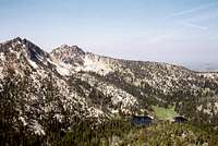
![Gunsight Mountain above...]() Gunsite Peak, Lees Peak, The Lakes Lookout from Anthony Lake
Gunsite Peak, Lees Peak, The Lakes Lookout from Anthony Lake![The south face of Angell Pk...]() Angell Peak
Angell Peak![Typical terrain on the east...]() Angell north ridge rocks
Angell north ridge rocks![View of the north side of the...]() East Angell ridge fins
East Angell ridge fins
I decided the day would be too boring to go back down now so I planned to head straight south on the connecting ridge to Angell Peak. Instead of taking the easy way I dropped down the nearly vertical slopes on the southeast side, which I found very hot in the exposed sun. Having my curiosity satisfied I worked my way to the ridge and headed south. This was very easy going on the rounded slope through open whitebark pine forest. But I got bored and moved to the east brim of the ridge where the ridge rock broke out of the slope into fractured granite blocks. As I climbed up through these rocks, things became progressively more difficult and I found myself hanging onto scraggly whitebark pine for dear life as I scooted across the rock faces and climbed through holes in the granite block piles. Soon I pulled myself up the last ledge and found myself at the top.
The summit area is small with precipitous cliffs to the east and south. The west and northwest slopes are quite gentle, but were covered with just enough snow to make passage difficult. The views from the top were fantastic, especially looking down the southeast ridge of the peak. This is a series of vertical fins of the most rugged nature. Looking to the west, I thought I would continue on the ridge around the Hoffer Basin hitting Lees Peak and the Lakes Lookout before descending back to Anthony Lake.
Again I found the ridge gentle on the right side, but the left side was a pile of rugged broken rocks. Having enough of that for a while I just hustled along towards Lees Peak where it looked like I would get my fill of rock. The ground on the saddle between Angle and Lees peaks is powdery from being torn up by mountain goats. The goat population has really increased in recent years, which is nice, but this is wreaking havoc on the fragile subalpine habitats. Looking up I was startled to see a goat perched on a rock looking down on me. I quietly stopped to take some pictures which he posed nicely for them, but as I tried to move closer he was gone. The trees on this ridge have snagged several patches of goat wool indicating they are common in the area.
It’s a quick walk to Lees Peak but there is nothing quick or easy about getting to the top. It is formed by a extensive series of granite towers that provide endless opportunities for those wanting serious rock climbing. Initially the highest tower did not look to provide a way to the top for a scrambler, but after investigating found a way I thought I could struggle up. On the north side of the tower there is a crack in corner that I was able to scoot my way up, but the last bit to the summit was blocked by an overhanging rock. To get by it I hung on the ledge and with air under my feet, moved hand over hand to the right to clear the overhang then pulled myself up to the top. The small flat area on the top if flat with large black lichen encrusted blocks lying around. Except for some fool who carved his name in the lichen there was little human sign around. The views were wonderful of course from the top, but looking at the rocks to the west convinced me that I didn’t want to continue over to The Lakes Lookout. The view to the south was especially nice overlooking the huge green of Crawfish Meadow, over 1,400 feet below.
Climbing down from the summit tower seemed more difficult than going up, but I eventually got the nerve to make it. I headed down amid the tall summit towers through a couloir on the south side. It was steep and the rock loose, but I marveled every step down at the towers and spectacular pinnacles of granite that reach skyward like a city of rock. This is clearly one of the most fantastic places I have ever been. As I came out of rocky dreamland the slope eased up and I entered a broad talus slope. After crossing this I was on the trail between Dutch Flat Saddle and The Lakes Lookout. Decision time. I could head west and get up to the old lookout site from the west or head east and head back on the Skyline Trail down Antone basin to Anthony Lakes. The latter seemed more interesting and would give me the option of extending to another peak to the south I had seen up top that looked interesting. So east it was.
![Lees Pk/Lakes Lookout]() Hoffer Lake Basin
Hoffer Lake Basin![Pk 8538 (fight) and Angell Pk...]() Dutch Flat Saddle
Dutch Flat Saddle![Black Lake at the northeast...]() Black Lake
Black LakeIt was an easy walk up to the saddle and though I wasn’t going to decide to scramble one more mountain until I got there, deep inside I knew I was going to go for it when I decided to head east. The next target was an unnamed peak, 8,525 feet that formed a triple divide between Dutch Flat, Crawford and Cunningham basins. It was a quick mile walk on a level trail across the northwest aspect of the mountain to Cunningham Saddle. Though it was July, there was still some snow about on the mountain which contributed to ample melt water running down the frequently exposed granite surfaces. The mountain seemed like it would be a simple walkup from the saddle and it was, but seemed difficult to me since it was the fourth summit of the day.
The route up the southwest ridge had burned in the 1980s which left the ground open, but in some places extensive prickly dead tree stems formed a bit of a barrier. Despite this, the going was straightforward and pretty easy. At the summit there are some large boulders that form the actual summit. The view to the south of Ruth Mountain was especially something to look at. I admired this shield-shaped peak put it high on my wish list for a future trip. The walk down the long but gentle north ridge went fast as long as I stayed out of the snow just below the ridge and soon I was back at Dutch Flat Saddle.
From here it was a slight rise to Angell Pass between Angell Peak and unnamed Peak 8,538, then it would be downhill all the way back to the car, a distance of about three miles. Angel Pass is a spectacular area with the huge vertical fins off the southeast ridge of Angell Peak, the black rock point of Peak 8,536 and the huge mass of Van Patton Butte rising across the subalpine meadows of the upper Antone Creek basin. The hike north through the basin gave a good look at the jagged rocks that break out of the Angell/Gunsite connecting ridge which I has traversed in the morning. It’s a good thing I didn’t get any further off the ridgeline as it was completely impassable. Soon the trail descended below the open subalpine forest into the dense spruce/fir forest enclosing Black Lake, the largest mosquito pit on the planet. This is a beautiful small lake encircled by forest and reflecting the high summit of Gunsight Mountain rising 1,000 feet above it.
The last mile of the trail is level through forest broken up by large swampy meadows and ponds. But soon the fun was over as I neared Anthony Lake and was inundated with the noise and frenzy of a beautiful place being loved to death. There must have been over 100 people camping, fishing, riding bikes and a dozen other things as loudly as they possibly good. I was happy to get to the car and down the road. Well, it had taken me several years, but I finally banged out some of the Oregon Blues in these spectacular Elkhorn Mountains. It would be the first of several forays to come.
![The south side of Lees Pk....]() Rock city on the south side of Lees Peak
Rock city on the south side of Lees Peak
Comments
No comments posted yet.