Mount Ruth and The Lakes Lookout
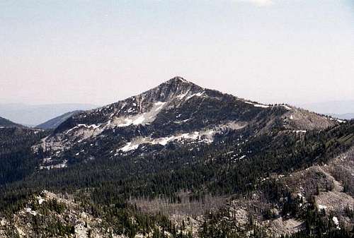
![The northeast face of Mt....]() Mount Ruth from the summit of Pk 8,525
Mount Ruth from the summit of Pk 8,525![The north ridge of Mt. Ruth...]() North ridge, Mt. Ruth
North ridge, Mt. Ruth![The small summit of Mount...]() The summit, Mt. Ruth
The summit, Mt. Ruth![Lost Lake Basin on the north...]() Lost Lake Basin
Lost Lake Basin![Looking down on the west side...]() West slope, Mt. Ruth
West slope, Mt. Ruth
I was fortunate to have an opportunity to return to the Elkhorns for the third time of the summer. My goal was Mount Ruth, which I had admired earlier in the year from the north earlier in the summer. The shield shaped peak looked like quite a quit simple hike up the gently sloped ridge, but since the round trip would require about an 15 mile round trip, I did not anticipate an easy day. Of course once I was into the day, I would find a way to make it tougher than I had originally planned. Seems I have developed a habit of doing this, but hey one must maximize limited summer days.
The starting point would again be Anthony Lake where I would get away with parking in the day use area and avoid the trailhead fee since I would be leaving and returning in the same day. The hike east of Anthony Lakes through the meadows, passed Black Lake and up through the upper basin of Antone Creek to Angell Pass. It was much as I remembered it from earlier in the summer except the snow was gone and though it was early morning it was already warming up. I made good time beyond the pass to Dutch Flat Saddle and across the slopes of Peak 8,525 to Cunningham Gap. From here on, I would be on new ground for me.
The hike seemed to be broken up into sections that made it easy to envision progress. After the previous gaps and saddles, the next point of reference would be Nip and Tuck Pass. This is an interesting natural gap between two large granite slabs situated directly on the ridge top. From here I passed into the North Fork Powder River basin for the first time. Much of the slopes had been affected by huge forest fires in the 1980s, which left the slopes in a state of brush or skeletal forest amid the talus slopes and outcrops. The trail descends from the gap towards Lost Lake, but my route would continue south back to the ridgeline and on to the next gap, Lost Lake Saddle. From here the ridge would form the long and gentle rise to the summit point of Mount Ruth.
The ridgeline rose so slowly that it seemed silly to be walking along it with the trail paralleling immediately below for quite some time. It may have made more sense to keep on the trail, and then hike up the poorly formed west ridge. The hike directly up the ridge seemed a little boring so I cheated onto the east brim a bit to scramble up and down across more interesting rocks. And as typical I soon found myself onto slopes that were a bit difficult for me. This wore me out a bit and it was a bit of a struggle to get back onto the ridge just before the summit. The summit point is a bit abrupt from any direction, but this mountain is quite an easy walk-up in general. Though the north and south ridges are very gradual, the east ridge and all the faces between the ridges have very steep and difficult slopes that I would perhaps play on someday. I spent quite a long time on the summit eating lunch and taking pictures of the distant views, the farthest being the outline of Strawberry Mountain to the southwest. However, the most interesting thing was the butterflies that fluttered over the summit by the thousands.
To get off the mountain I headed straight down the west aspect intending to reach the trail to head back north. While this seemed like a simple task it was not. The footing was terrible on volleyball-sized rocks that moved irregularly with every step. It was some of the strangest and most tricky walking I had ever encountered. Making very slow progress and fearing a broken ankle, I picked myself back to the north ridge line and headed north until I found the start of the small poorly defined ridge that would take me west to the trail below. Its not so much a ridge as a slight aspect change in the slope, but the surface was mostly loose open soil through an open forest of stunted whitebark pine.
![The north face of the west...]() The Lakes Lookout from its north base
The Lakes Lookout from its north base![This is the north side of The...]() The Lakes Lookout from north base
The Lakes Lookout from north base![This is the route from the...]() Lees/Lakes LO pass
Lees/Lakes LO pass![The Lakes LO Summit]() The Lakes Lookout summit
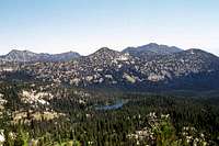
The Lakes Lookout summit![This view south from the...]() Crawfish Meadow
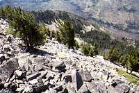
Crawfish Meadow![The high point of The Lakes...]() Summit rock
Summit rock![This small meadow at Hoffer...]() Lees and The Lakes LO from Hoffer Basin
Lees and The Lakes LO from Hoffer Basin
Once back on the trail I headed north. After an eventless hike I was back at Dutch Flat Saddle and faced with a decision. I could continue north through Angell Pass and retrace my route back to Anthony Lake or I could head west and hike up to the top of The Lakes Lookout. It was getting late in the afternoon, but it would be a simple hike on the trail so I headed west. It was a simple hike, but as I found myself ascending towards the trailhead I was pretty beat after walking a fast 15 miles. Still I staggered on reaching the often crowded summit. Fortunately I had the mountain to myself and spent a fair amount of time exploring the rocks of the two summit points. The lookout no longer stands and its debris are scattered about just below the highest large rocks creating an unsightly mess. The view from the top is spectacular with Crawfish Meadow far below to the south and the Hoffer Lakes and the Anthony Lakes group beyond.
Since the shadows were now getting long, I decided I should get down. Rather than retrace my steps back on the trail and then walk down the Anthony Lakes Ski Area road, I dropped of the east shoulder to the saddle between The Lakes Lookout and Lees Peak. This was a fun down-scramble that required a little route finding just before reaching the saddle, which is fine powder soil having been pawed intensely by mountain goats. I dropped down to the flat immediately below, which supports a beautiful subalpine meadow and pond backing up to the talus. From here I enjoyed the fantastic setting of a giant amphitheatre formed by the lookout, Lees Peak, Angell Peak and their extending ridges. The next move was straight north across the top of the large granite mound that pokes up behind the Hoffer Lakes. Once down to those lakes I had to meander around the west meadow that is very wet to find the way to the trail. The clouds of mosquitoes are horrendous. But from the Hoffer Basin, it is only a few minutes down the trail to Anthony Lakes and the trailhead. And so ends my third trip this summer into this section of the Elkhorns in which I have summated most of the northern peaks.
Comments
No comments posted yet.