|
|
Mountain/Rock |
|---|---|
|
|
48.12524°N / 113.65893°W |
|
|
Flathead |
|
|
Hiking, Scrambling |
|
|
Summer, Fall |
|
|
6676 ft / 2035 m |
|
|
Overview
Northwestern Montana's Flathead Range adjoins some of the state's most-visited and spectacular landscapes -- Glacier National Park, Hungry Horse Reservoir, and the Swan Mountains -- but the range itself is surprisingly little-traveled. Mount Baptiste (8379') marks the second-highest mountain group in the Flatheads, and dominates the southern portion of the range. With a little effort, Baptiste hikers can find solitude and exceptional views.
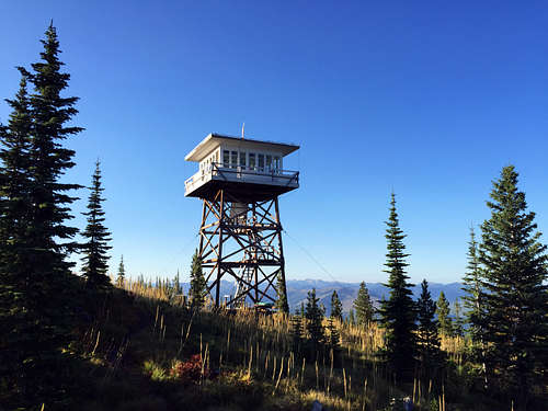
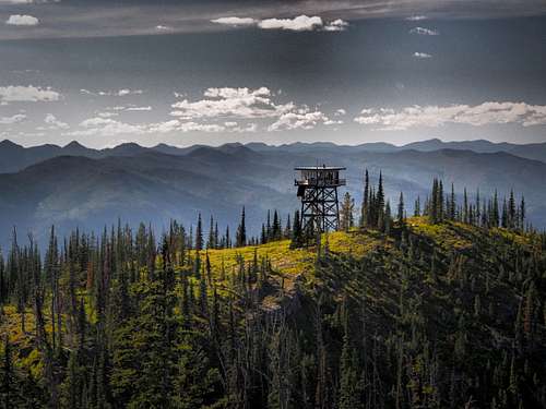
Most hikers in the area choose Baptiste Lookout (6676') as their destination. Baptiste is one of the seven staffed lookouts remaining in the Flathead National Forest, a working link to both the forest's history and its current fire management, and the tower offers great views of Hungry Horse Reservoir and the Swan Range. From the lookout, it's a relatively straightforward climb to the mountain's summit, with its expansive, top-of-the-world views.
Some history ...
Mount Baptiste is named for a French prospector and trapper who was an early Euro-American settler in the region -- his full name is unknown, but it may have been Baptiste Zeroyle. Baptiste lived alone in a cabin southwest of the mountain at the beginning of the 20th century, the only year-round resident of the South Fork country. He located several copper mining claims near the mountain, including one almost on its summit. Others searched for copper in the area as well, and the site of a small prospect is visible about four miles up the Baptiste trail. Baptiste died in his cabin during the winter of 1908-09, and is buried near the site.
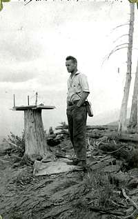
The ridge where Baptiste Lookout now stands was first used for fire detection by the Flathead National Forest over a century ago -- at least as early as 1915. During the location's first years, the lookout lived in a tent near the ridge and plotted fire locations using an alidade mounted on a convenient tree stump. The first tower at Baptiste was a 30' structure built in about 1928, one of a vast number of lookout buildings constructed on the Flathead during the 1920s and 1930s. By the start of World War II, close to 150 such lookout sites existed on the forest, and the man stationed at Baptiste could see at least a dozen other lookout locations from the Baptiste catwalk.
The number of staffed lookouts on the Flathead declined rapidly after World War II, but Baptiste was considered an important-enough location that a replacement tower was erected at the site in 1964. The new tower was staffed regularly through about 1971 -- and then largely abandoned for the next 40 years. A concerted effort by Forest Service employees in 2011 and 2012 saw the tower restored, and Baptiste returned to service in 2012. Baptiste was staffed by volunteers from 2012 through 2017, and it has been manned by a Forest Service employee since 2018. It's one of four staffed lookouts in the South Fork drainage: Baptiste and Firefighter, above Hungry Horse Reservoir; and Spotted Bear and Jumbo in the Bob Marshall country.
Getting there
Note: the Forest Service relocated the Baptiste trailhead in 2021. The following directions describe the new route, which is fully open but may not be signed at the time of your visit.
To reach the Baptiste trailhead, leave US 2 at Martin City and follow the East Side Road along Hungry Horse Reservoir for approzimately 35 miles. This is a well-maintained gravel road, but is infamous for its fast-moving, take-no-prisoners logging trucks. Turn left (east) at USFS Road #1632, which is signed for the Baptiste trailhead. (To protect grizzly bear habitat, Road #1632 is behind a gate that remains closed until July 1 each year.)
Take a hard left at an unsigned intersection 0.6 miles down this road, and continue east, passing the former trailhead after another 0.7 miles. Park at the end of the public road, approximately 1.2 miles past the unsigned intersection. There was commercial logging activity on this road during the summer of 2021.
Note: Some maps, including the usually-excellent Cairn Topographcs map of the Bob Marshall, incorrectly locate the Baptiste trailhead and/or the route of the trail itself. The Cairn map also under-reports the length of the trail!
Route Information
Baptiste Lookout hike
The current Baptiste Lookout trail (#63) is approximately 5.6 miles long, with a 2,700' elevation gain. It receives annual maintainance but is lightly used and brushy in places. Bears frequent the area, especially along the upper portion of the trail during huckleberry season, so carry bear spray and make noise where visibility is limited.
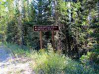
From the trailhead, begin by following the Logan-Dirtyface Trail (#62) eastward. After about 1/10 mile, turn right onto the newly-built section of the Baptiste trail, which wanders haphazardly to the southwest through heavy forest for 0.3 miles to a connection with the prior trail. Turn left onto the original trail there, and follow a series of long, gentle switchbacks that slowly climbs the side of the mountain. The first of several good water sources marks the halfway point of the hike, and the trail reaches a prominent ridgeline a few hundred yards later, providing a first, distant view of the lookout on the other side of a steep, narrow canyon.
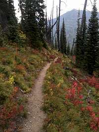
Just before reaching the ridgeline, the trail enters an area that was impacted by a Forest Sevice prescribed burn in September 2022. The burn area continues intermittently for approximately 1.3 miles, offering stark views of a fire's immediate impact, while simultaneously opening up additional views. Trail retreading and hazard tree removal have mitigated the fire's impact to hikers, but it's always wise to be cautious when traversing a burn area.
After rounding the ridge, the trail heads east along the north canyon wall, climbing somewhat more slowly and occationally offering fine views of the mountain. (Watch for a brief glimpse of the waterfall near the head of the canyon far below.) The route eventually curves south to enter Silver Basin, a wooded cirque at the head of the canyon. The trail through the basin is often muddy, and includes the last water sources before the summit. After passing a large avalanche chute at the west end of the basin, a final series of switchbacks climbs to the lookout site on the ridgetop.
A Forest Service employee typically lives at the lookout from late June until mid-September. When visiting this or any lookout, it's considered good etiquette to call out as you approach, to let the lookout know he has a visitor. Views from the lookout catwalk are substantially better than from ground level, and if conditions permit the lookout will usually invite you up for a tour. He will also happily accept any proffered snacks.
Mount Baptiste summit
The Mount Baptiste summit is about a mile east of the lookout, and is 1,700' higher. Most people heading for the summit will first hike to the lookout and then continue south, working steeply up through the trees to Point 7946, on Baptiste's southwestern ridge. The lower part of this trek is a painful slog through undergrowth and over a ridiculous number of downed trees; some of this can be avoided by staying hiker left, following the jagged northern end of the ridge that is very visible from the lookout.
Reaching Point 7946 opens up tremendous views into the Bob Marshall country to the south. The remainder of the hike is a spectacular walk along the ridgeline to the Baptiste summit, with few technical challenges. To avoid a section of Class 4 cliffs, one needs to drop slightly onto the southeast ridge face after passing the low point of the saddle; this will make the overall hike no more than Class 2. The summit offers exceptional views in all directions, including into the southwestern portion of Glacier National Park.
Climbers can shorten their return hike by bypassing the lookout and descending directly into Silver Basin, either following one of the gullies leading into the eastern end of the basin or the large avalanche chute to the south. Both options are steep but relatively straightforward; staying hiker right is often a good choice. Any of those routes could also be used for the ascent -- bypassing the lookout, Point 7946, and much of the ridge -- but the best routes may not be discernable from below. Stay hiker left, especially if ascending the avalanche chute.
Red Tape/Camping
No permits for hiking, parking, or dispersed camping are required. As noted above, the access road to the trailhead (#1632) is only open to motorozed use between July 1 and November 30.
There are free, relatively lightly used Forest Service campgrounds along the Hungry Horse Reservoir road, south of the turnoff to the trailhead road. Terrain and ground cover limit dispersed camping both near the road and along Trail 63, though there are camp locations near the ridgeline, in Silver Basin, and in the vicinity of the lookout. Obtain permission from the lookout staffer before setting up camp in that immediate area, and avoid the marked helispot to the south of the lookout.
When to Go
Summer and fall. Most years, the last, steep mile of the lookout trail remains snow-covered until mid-June, and making the trip before July 1 will add 3.6 miles of hiking to the round trip, due to the seasonal closure of Road #1632. The route along the ridge leading to the Baptiste summit is likely to be impacted by snow into early July.
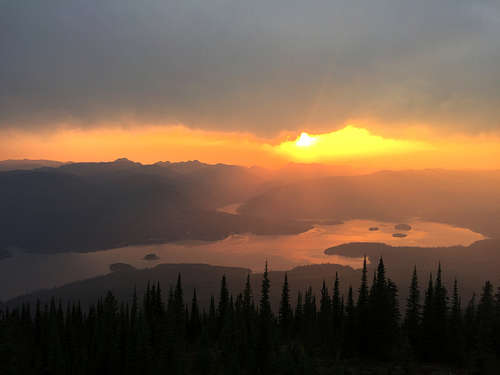
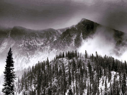
Views