
-
 19529 Hits
-
 82.48% Score
-
 15 Votes
|
|
Mountain/Rock |
|---|---|
|
|
48.32472°N / 113.755°W |
|
|
Flathead |
|
|
Mountaineering |
|
|
Summer, Fall |
|
|
8590 ft / 2618 m |
|
|
Overview

|
|---|
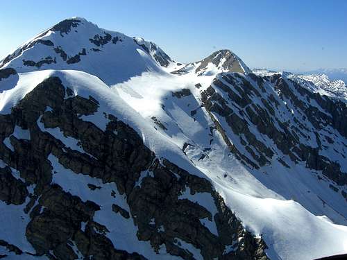
Mount Grant is located in the Great Bear Wilderness of northwestern Montana. At 8,590 feet Mount Grant is a mere 115 feet lower in elevation than its nearest neighbor and highest peak in the Great Bear Wilderness, Great Northern Mountain. Views from the summit are similar to those of Great Northern with the exception of those to the north that are somewhat blocked by Great Northern Mountain at 8,705 feet.
In September of 1964 the U.S. Congress passed The Wilderness Act which provided a vehicle to designate certain areas for preservation of wilderness.

|
|---|
The headwaters of Middle Fork of the Flathead River are located in the southern portion of the Great Bear wilderness. This vast area has few established trails and rises from an elevation of close to 4,000 feet to the highest point in the Great Bear which is Great Northern Mountain.
In the rugged country live wolverine, deer, elk, moose, grizzly bear, black bear, mountain lion, wolf, mountain goat, and mountain sheep.
The fish living in South Fork of the Flathead are Westslope Cutthroat and Bull Trout which The Middle Fork of the Flathead River is wild under the National Wild and Scenic River System. The Hungry Horse Basin is stocked with Westslope Cutthroat Trout and there is currently a management plan to clear out the old stock of Yellowstone Cutthroat Trout that threaten the Southfork of the Flathead River.
The Southfork is unique due to the Hungry Horse Dam blocking any non-native fish from entering the system. The Southfork empties the Bob Marshal Wilderness System and is teeming with wild catchable cutthroat and Bull Trout.
The Views:
 Hungry Horse Reservoir
![Mount Jackson from Great Northern]() Mount Jackson in Glacier National Park
Mount Jackson in Glacier National Park
![St. Nicholas from Great Northern]() Mount St. Nicholas in Glacier National Park
Mount St. Nicholas in Glacier National Park
![Final False Summit on Return]() False Summit, Vantana photo
False Summit, Vantana photo
![Looking southeast from Great Northern...]() Looking South from Great Northern Montain, saintgrizzly photo
Looking South from Great Northern Montain, saintgrizzly photo
![Descent from Great Northern]() Descent Route from Great Northern Mountain
Descent Route from Great Northern Mountain
Getting There
![Mt. Grant/Great Northern Trailhead Map]()
Access to the Great Bear Wilderness is by trails originating from forest roads located in the major drainages to the north and west. Major roads adjacent to the Great Bear include U.S. Highway 2 to the north and Montana Highway 83 to the west.
To reach the trailhead traveling East from the Flathead Valley towards Glacier National Park drive east from Hungry Horse, Montana for approximately 1 mile to Martin City. When traveling West from Glacier National Park pass through Coram and then look for The Packer’s Roost and then look for the sign that indicates a left hand turn to Martin City. Follow the Eastside Hungry Horse Reservoir road through Martin City until the pavement ends in two miles or so. How enjoyable the next 13 miles is will depend on how long it’s been since the road was graded. It has been know to be full of potholes and washboards at times but other times it has been an excellent drive. Still do not expect to drive over 35 mph due to the numerous curves.
While traveling through the Coram Experimental Forest expect to see deer and other smaller forest creatures. Access to Hungry Horse Reservoir is available at both Abbot Bay and Emery Bay. There is overnight camping available at Emery Bay as well.
After passing Emery Bay turnoff travel another 8.7 miles to the unmarked road #1048. This is a SHARP left hand turn located in that direct vicinity of Road #1048 is a sign that reads Firefighter Mountain 4 as well as Spotted Bear 39.
The trailhead is another ½ mile up this road. There is parking before and after the bridge. Please do not block the gates.
The Standard/Northwest Ridge Route as described by saintgrizzly is located on the North side of Hungry Horse Creek and the Dudley Bowl route by BobSiler is located on the South side of the creek.
Red Tape
![Mount Grant]() Mount Grant and Grant Glacier. Photo taken from helicopter in June 2009.
Mount Grant and Grant Glacier. Photo taken from helicopter in June 2009.
Foot travel and pack animals are the only allowable means of transportation in the Great Bear Wilderness. For a list of all of the regulation please visit Great Bear Wilderness Regulations.
Route Overview:
![Grant Topo]()
Follow saintgrizzly’s excellent route description to the 8,705 foot summit of Great Northern Mountain. This climb is approximately 5,000 feet in elevation gain and approximately 4 miles one-way.
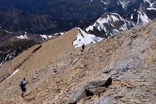
From Great Northern Mountain follow the ridge to the south for approximately 1.25 miles until reaching the summit of Mount Grant. This is most easily done by staying at or near the top of the knife-shaped ridge. A goat trail can be followed for a portion of route.
Some interesting class 3 or 4 climbing (Glacier Park Rating System) can be had if so desired. If an easier approach is desired skirt below the ridge and walk across the scree fields to the west of the ridge. Then scramble up the easiest route to the summit.
Camping
Ample camping can be found along the east shores of Hungry Horse Reservoir. Emery Bay is the closest campground.
For other local campgrounds follow this link: Local Campgrounds Equipment:
In addition to the usual scrambling gear bring hiking poles, extra water and lots of stamina are needed for this trip.
If an early or late season climb is desired plan on dealing with snow and carry the necessary ice axe, crampons and avalanche gear.
If you are climbing in the Great Bear Wilderness remember that this area is frequented by bears, both black and grizzly. You are in bear country. Carry your bear deterrent spray, don’t climb alone and make some noise.
For more information please go to Glacier National Park's website for Bear Information. The U.S. Forest Service also has helpful information on Grizzly Bear Management.External Links
Glacier Mountaineering Society
Visit Montana
 Mount Jackson in Glacier National Park
 Mount St. Nicholas in Glacier National Park
![Final False Summit on Return]() False Summit, Vantana photo
False Summit, Vantana photo
![Looking southeast from Great Northern...]() Looking South from Great Northern Montain, saintgrizzly photo
Looking South from Great Northern Montain, saintgrizzly photo
![Descent from Great Northern]() Descent Route from Great Northern Mountain
Descent Route from Great Northern Mountain
Getting There
![Mt. Grant/Great Northern Trailhead Map]()
Access to the Great Bear Wilderness is by trails originating from forest roads located in the major drainages to the north and west. Major roads adjacent to the Great Bear include U.S. Highway 2 to the north and Montana Highway 83 to the west.
To reach the trailhead traveling East from the Flathead Valley towards Glacier National Park drive east from Hungry Horse, Montana for approximately 1 mile to Martin City. When traveling West from Glacier National Park pass through Coram and then look for The Packer’s Roost and then look for the sign that indicates a left hand turn to Martin City. Follow the Eastside Hungry Horse Reservoir road through Martin City until the pavement ends in two miles or so. How enjoyable the next 13 miles is will depend on how long it’s been since the road was graded. It has been know to be full of potholes and washboards at times but other times it has been an excellent drive. Still do not expect to drive over 35 mph due to the numerous curves.
While traveling through the Coram Experimental Forest expect to see deer and other smaller forest creatures. Access to Hungry Horse Reservoir is available at both Abbot Bay and Emery Bay. There is overnight camping available at Emery Bay as well.
After passing Emery Bay turnoff travel another 8.7 miles to the unmarked road #1048. This is a SHARP left hand turn located in that direct vicinity of Road #1048 is a sign that reads Firefighter Mountain 4 as well as Spotted Bear 39.
The trailhead is another ½ mile up this road. There is parking before and after the bridge. Please do not block the gates.
The Standard/Northwest Ridge Route as described by saintgrizzly is located on the North side of Hungry Horse Creek and the Dudley Bowl route by BobSiler is located on the South side of the creek.
Red Tape
![Mount Grant]() Mount Grant and Grant Glacier. Photo taken from helicopter in June 2009.
Mount Grant and Grant Glacier. Photo taken from helicopter in June 2009.
Foot travel and pack animals are the only allowable means of transportation in the Great Bear Wilderness. For a list of all of the regulation please visit Great Bear Wilderness Regulations.
Route Overview:
![Grant Topo]()
Follow saintgrizzly’s excellent route description to the 8,705 foot summit of Great Northern Mountain. This climb is approximately 5,000 feet in elevation gain and approximately 4 miles one-way.
From Great Northern Mountain follow the ridge to the south for approximately 1.25 miles until reaching the summit of Mount Grant. This is most easily done by staying at or near the top of the knife-shaped ridge. A goat trail can be followed for a portion of route.
Some interesting class 3 or 4 climbing (Glacier Park Rating System) can be had if so desired. If an easier approach is desired skirt below the ridge and walk across the scree fields to the west of the ridge. Then scramble up the easiest route to the summit.
Camping
Ample camping can be found along the east shores of Hungry Horse Reservoir. Emery Bay is the closest campground.
For other local campgrounds follow this link: Local Campgrounds Equipment:
In addition to the usual scrambling gear bring hiking poles, extra water and lots of stamina are needed for this trip.
If an early or late season climb is desired plan on dealing with snow and carry the necessary ice axe, crampons and avalanche gear.
If you are climbing in the Great Bear Wilderness remember that this area is frequented by bears, both black and grizzly. You are in bear country. Carry your bear deterrent spray, don’t climb alone and make some noise.
For more information please go to Glacier National Park's website for Bear Information. The U.S. Forest Service also has helpful information on Grizzly Bear Management.External Links
Glacier Mountaineering Society
Visit Montana
 False Summit, Vantana photo
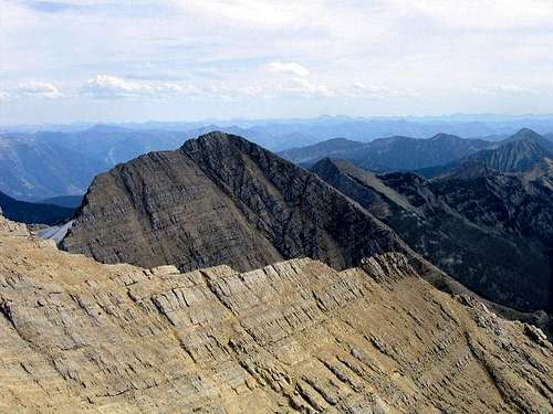 Looking South from Great Northern Montain, saintgrizzly photo
![Descent from Great Northern]() Descent Route from Great Northern Mountain
Descent Route from Great Northern Mountain
Getting There
![Mt. Grant/Great Northern Trailhead Map]()
Access to the Great Bear Wilderness is by trails originating from forest roads located in the major drainages to the north and west. Major roads adjacent to the Great Bear include U.S. Highway 2 to the north and Montana Highway 83 to the west.
To reach the trailhead traveling East from the Flathead Valley towards Glacier National Park drive east from Hungry Horse, Montana for approximately 1 mile to Martin City. When traveling West from Glacier National Park pass through Coram and then look for The Packer’s Roost and then look for the sign that indicates a left hand turn to Martin City. Follow the Eastside Hungry Horse Reservoir road through Martin City until the pavement ends in two miles or so. How enjoyable the next 13 miles is will depend on how long it’s been since the road was graded. It has been know to be full of potholes and washboards at times but other times it has been an excellent drive. Still do not expect to drive over 35 mph due to the numerous curves.
While traveling through the Coram Experimental Forest expect to see deer and other smaller forest creatures. Access to Hungry Horse Reservoir is available at both Abbot Bay and Emery Bay. There is overnight camping available at Emery Bay as well.
After passing Emery Bay turnoff travel another 8.7 miles to the unmarked road #1048. This is a SHARP left hand turn located in that direct vicinity of Road #1048 is a sign that reads Firefighter Mountain 4 as well as Spotted Bear 39.
The trailhead is another ½ mile up this road. There is parking before and after the bridge. Please do not block the gates.
The Standard/Northwest Ridge Route as described by saintgrizzly is located on the North side of Hungry Horse Creek and the Dudley Bowl route by BobSiler is located on the South side of the creek.
Red Tape
![Mount Grant]() Mount Grant and Grant Glacier. Photo taken from helicopter in June 2009.
Mount Grant and Grant Glacier. Photo taken from helicopter in June 2009.
Foot travel and pack animals are the only allowable means of transportation in the Great Bear Wilderness. For a list of all of the regulation please visit Great Bear Wilderness Regulations.
Route Overview:
![Grant Topo]()
Follow saintgrizzly’s excellent route description to the 8,705 foot summit of Great Northern Mountain. This climb is approximately 5,000 feet in elevation gain and approximately 4 miles one-way.
From Great Northern Mountain follow the ridge to the south for approximately 1.25 miles until reaching the summit of Mount Grant. This is most easily done by staying at or near the top of the knife-shaped ridge. A goat trail can be followed for a portion of route.
Some interesting class 3 or 4 climbing (Glacier Park Rating System) can be had if so desired. If an easier approach is desired skirt below the ridge and walk across the scree fields to the west of the ridge. Then scramble up the easiest route to the summit.
Camping
Ample camping can be found along the east shores of Hungry Horse Reservoir. Emery Bay is the closest campground.
For other local campgrounds follow this link: Local Campgrounds Equipment:
In addition to the usual scrambling gear bring hiking poles, extra water and lots of stamina are needed for this trip.
If an early or late season climb is desired plan on dealing with snow and carry the necessary ice axe, crampons and avalanche gear.
If you are climbing in the Great Bear Wilderness remember that this area is frequented by bears, both black and grizzly. You are in bear country. Carry your bear deterrent spray, don’t climb alone and make some noise.
For more information please go to Glacier National Park's website for Bear Information. The U.S. Forest Service also has helpful information on Grizzly Bear Management.External Links
Glacier Mountaineering Society
Visit Montana
 Descent Route from Great Northern Mountain
Getting There

Access to the Great Bear Wilderness is by trails originating from forest roads located in the major drainages to the north and west. Major roads adjacent to the Great Bear include U.S. Highway 2 to the north and Montana Highway 83 to the west.
To reach the trailhead traveling East from the Flathead Valley towards Glacier National Park drive east from Hungry Horse, Montana for approximately 1 mile to Martin City. When traveling West from Glacier National Park pass through Coram and then look for The Packer’s Roost and then look for the sign that indicates a left hand turn to Martin City. Follow the Eastside Hungry Horse Reservoir road through Martin City until the pavement ends in two miles or so. How enjoyable the next 13 miles is will depend on how long it’s been since the road was graded. It has been know to be full of potholes and washboards at times but other times it has been an excellent drive. Still do not expect to drive over 35 mph due to the numerous curves.
While traveling through the Coram Experimental Forest expect to see deer and other smaller forest creatures. Access to Hungry Horse Reservoir is available at both Abbot Bay and Emery Bay. There is overnight camping available at Emery Bay as well.
After passing Emery Bay turnoff travel another 8.7 miles to the unmarked road #1048. This is a SHARP left hand turn located in that direct vicinity of Road #1048 is a sign that reads Firefighter Mountain 4 as well as Spotted Bear 39.
The trailhead is another ½ mile up this road. There is parking before and after the bridge. Please do not block the gates.
The Standard/Northwest Ridge Route as described by saintgrizzly is located on the North side of Hungry Horse Creek and the Dudley Bowl route by BobSiler is located on the South side of the creek.
Red Tape
 Mount Grant and Grant Glacier. Photo taken from helicopter in June 2009.
Foot travel and pack animals are the only allowable means of transportation in the Great Bear Wilderness. For a list of all of the regulation please visit Great Bear Wilderness Regulations.
Route Overview:

Follow saintgrizzly’s excellent route description to the 8,705 foot summit of Great Northern Mountain. This climb is approximately 5,000 feet in elevation gain and approximately 4 miles one-way.
From Great Northern Mountain follow the ridge to the south for approximately 1.25 miles until reaching the summit of Mount Grant. This is most easily done by staying at or near the top of the knife-shaped ridge. A goat trail can be followed for a portion of route.
Some interesting class 3 or 4 climbing (Glacier Park Rating System) can be had if so desired. If an easier approach is desired skirt below the ridge and walk across the scree fields to the west of the ridge. Then scramble up the easiest route to the summit.
Camping
Ample camping can be found along the east shores of Hungry Horse Reservoir. Emery Bay is the closest campground.For other local campgrounds follow this link: Local Campgrounds
Equipment:
In addition to the usual scrambling gear bring hiking poles, extra water and lots of stamina are needed for this trip.If an early or late season climb is desired plan on dealing with snow and carry the necessary ice axe, crampons and avalanche gear.
If you are climbing in the Great Bear Wilderness remember that this area is frequented by bears, both black and grizzly. You are in bear country. Carry your bear deterrent spray, don’t climb alone and make some noise.
For more information please go to Glacier National Park's website for Bear Information. The U.S. Forest Service also has helpful information on Grizzly Bear Management.
External Links
Glacier Mountaineering SocietyVisit Montana