Bear Creek, San Gabriel Canyon
Bear Creek is one of my favorite spots in San Gabriel Canyon. There are two trails, Lower Bear Creek Trail and Upper Bear Creek Trail.
Great News - Both the road and the trail are now open. Upper Bear Creek Trail is closed again, part of the trail slid down into the canyon (in 2008), hopefully to be rebuilt in 2009. Also I think the road is now closed just before the trailhead. Check for updates before going.
To reach the trailheads, take Highway 39 from Azusa, through San Gabriel Canyon, going past the bridge to the East Fork, and continue on past the ORV parking area. Shortly after this you will come to a bridge, where the road turns north. There is a small parking lot on your left, just before the bridge, and a larger one on the left, after the bridge. The road is still closed just past the trailhead for Upper Bear Creek Trail.
The route to the Lower Bear Creek Trail follows the paved road (closed to private vehicles) on the left of the San Gabriel River, before the bridge. In about a mile, there is another bridge. Cross the bridge and go left and down to the river. The trail starts here and goes under the bridge, following on the left side of the river. Almost immediately, the San Gabriel River turns to the right, and Bear Creek continues straight ahead.
I hiked this trail twice in the spring of 2006, and once in the fall. The first trip was about March 20th. The creek was higher than normal but I was able to make the many crossings (more than 20) without any problem. There is a fairly good trail up to the second wilderness campsite. From there on the trail has been washed out, there are bits and pieces of use trail, and a lot of hunting for the trail in between. There is also a lot of poison oak, so be careful. Most of the time the trail follows close to the creek, but at one point it goes up above the bank on the right side, to get around narrow passages in the canyon.
There is a large boulder on the right side of the creek (no trail at this point), where the Upper Bear Creek Trail starts. The trail starts behind the boulder and is not visible from the creek. I have been there many times, but this time I walked right by it without even seeing it. When I reached a point in the creek where it was impossible to continue, without going through waist deep ponds in a narrow canyon, I was finally realized for sure that I had missed the turn off. It had been a few years since I had been on the trail, and high water had washed out many of the previous landmarks, including my favorite camping spot near the junction.
After backtracking and finding the boulder, I started hiking up the Upper Bear Creek Trail. This trail was rebuilt just a few years ago, but due to a fire, it has been closed for most of that time. However, it was still in fairly good shape and the dead trees from the fire have been cleared from the trail. I think it is about 5½ miles from the creek up to the trailhead on Highway 39, with Smith Saddle being about half way. It is a good climb up to there, and then all downhill to the highway. I reached the saddle just after sunset, and after a quick break, started down the other side. The trail crew had been working there, and their equipment was still on the trail, including their little tracked trail building machine.
It was dark by the time I reached the trailhead, but I had my headlight so was able to read the "Trail Closed" sign! I started walking down the highway to my car, which was about six miles away. I was surprised to meet a few cars coming up the road; evidently some people have a key for the gate. There were no cars going down though, so I had to walk all the way back to my car at the bridge.
River Crossing Practice
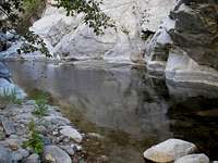
![Upper Bear Creek Narrows]() Narrows in Upper Bear Creek
Narrows in Upper Bear Creek![Trail Crossing, Bear Creek]() Trail Crossing
Trail CrossingThe second trip, on March 29th, was a river crossing training trip for my upcoming Pacific Crest Trail hike (PCT). It had been raining quite a lot and I expected the creek to give me some good, but easy, fording practice. I had my full pack and trekking poles, and was planning on crossing the creek wearing my lightweight hiking shoes, as I would be doing in the Sierras. I was greatly surprised to see how much more water there was in the creek since the last time, about 10 days earlier. I hadn't done much river crossing before, and was totally unprepared for the force of the water. It was no longer just a little creek!
I found that it was almost impossible to plant my trekking poles where I wanted to. The current would carry them downstream a couple of feet from where I tried to put them. On the fourth crossing, I reached a point about four feet from the far bank, and the force of the water was too great to continue. There was a sturdy looking root along the bank so I made a lunge for that and made it across. I was hiking alone, so I soon realized that it wasn't a smart idea to continue if it got any more difficult. The next crossing wasn't quite as bad, but number six was much worse, and I wisely decided that it was time to call it quits and turn around. I did find a little better place to cross number four, and made it back across all of them safely.
Return in the Fall
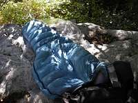
![Rock Top Camp, Bear Creek]() Rock Top Camp
Rock Top CampIn October, after finishing the PCT, I returned to do the hike for the third time, this time as an overnight backpacking trip. The water had gone down and I was able to make all the crossings as normal, without getting my feet wet. However, I still missed the boulder for the junction to the upper trail, and went too far. The top of the boulder is fairly flat, so I filled in some of the dips with sand and camped on top of the boulder. I also did another hike up to Smith Saddle, again arriving just after sunset, and then heading back down the same way. In the morning, I slept in, and waited for the sun to shine on me before getting up. That was a luxury that we didn't have on the PCT.
I have seen a bear on two different hikes along the lower trail, but no sign of one on any of these three hikes. Hopefully it wasn't the same bear that was causing problems a few years ago up at Little Jimmy Campground, which isn't too far away. That one had to be killed.


Comments
Post a Comment