East Fork of the San Gabriel River
My friend Frank and I a couple of months back had planned a hiking trip, but we weren't sure exactly where. Originally we had planned on Big Sur, but with the rapid spread of wildfires in that area and around the state, we decided something a bit closer to home (Los Angeles) would be better. I did some searching and found the East Fork of the San Gabriel River in a couple of locations, including here:
http://www.dankat.com/advents/eastfk.htm
It was also mentioned in a couple of other books I have on hiking in the Angeles National Forest and Southern California. I had wanted to do the hike in two days when I first looked into it, but my buddy preferred to knock the whole thing out in a day, so we decided on making the trip in one, long day.
Planning
We planned on doing the trip from north to south, leaving from Vincent Gap outside Wrightwood and traveling all the way to the East Fork Ranger Station outside Azusa's Highway 39. This, obviously, would require a car shuttle, which was one of the major problems in doing this hike in a day.
Coming from Pasadena, it would take at least 1hr to get up to the East Fork and drop off the first car, then another 1.5 hours to get to Vincent Gap. Then, when the hike was completed, we would have to drive the 1.5 hours back to Vincent Gap again, and then another 1.5 hours back to Pasadena.
In other words, on top of hiking roughly 17 miles, we were looking at nearly 5.5 hours driving time (2.5 hours from Pasaena to Vincent Gap and 3 hours from the East Fork to Vincent Gap and then back to Pasadena).
We decided a wake-up time of 4:30 would hopefully put us hiking around 7:30am. We packed light, each person with a 12-13pound pack, which included about 5pounds of water (2.5liters).
Vincent Gap to Big Horn Mine (accidentally)
We woke up at 4:20am and were on the road shortly before 5am. It was just turning 6am when we dropped off the first car at the East Fork Ranger Station.
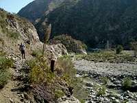
![eastforkfromeftrailhead]() Looking north up the East Fork - the morning of the hike
Looking north up the East Fork - the morning of the hike
We ended up getting to Vincent Gap around 7:45am and started hiking around 8:10am. We started hiking down the Mine Gulch Trail and began looking for the Vincent Gulch Trail. I remembered reading this trail broke away from the Mine Gulch Trail and head down the slope somewhat steeply. WEll, we kept walking.... and walking.... and walking.... until I saw this:
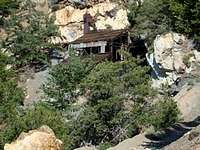
![Big Horn Mine]() Big Horn Mine
Big Horn Mine
A couple of cuss words later I explained to my friend we had missed the turn-off and promptly turned around. The main problem was time, which we didn't have a lot of in the first place. We had arrived at Big Horn, nearly 1.6 miles from the trailhead, at almost 9am. Not only did this put us almost an hour behind our already late schedule, but added nearly 2.5 to 3 miles to our already roughly 17mile trip.
Big Horn Mine to Mine Gulch Flat
We decided rather quickly we should take the scree slope that follows the drainage just south of the Vincent Gap Trail and make our way down to Mine Gulch Flats cross-country.
![ScreeSlope]() Scree Slope
Scree Slope
After about 45 minutes of sliding around later we finally got into the forest and began following the creek to the East Fork. Just when we reached the East Fork we met up with this guy decked out in camo, brandishing a rifle. He kind of chuckled when he mentioned someone had knocked down the trail sign for the Vincent Gap Trail, and how he always brings a gun when he hikes alone because he was tracked by a cougar once in the area....
We finally arrived at Mine Gulch Flats in the scorching sun around 10:45am, nearly an hour behind our scheduled time. Here we found the trail that headed off to Prairie Fork and the bluest swimming pool we were to see all day.
![Mine Gulch Flats]() Pool at Mine Gulch
Pool at Mine GulchMine Gulch/Prairie Fork Confluence to Fish Fork
We also encountered a pretty enormous mudslide, I believe coming out of Mine Gulch.
![Mine Gulch Mudslide]() mudslide at Mine Gulch
mudslide at Mine Gulch
Although most of it looked pretty solid from baking in the sun, I quickly found out some sections were a little loose.
![Mud Shoes]() mudfoot at Mine Gulch
mudfoot at Mine Gulch
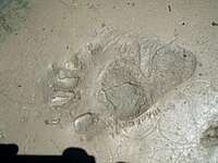
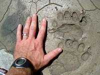
As we made our way from Mine Gulch, we were trying to track our position by identifying gullies to the east and west, most notably Alder Gulch. This proved to be the allusive gully of the day, and it wasn't until we reached Fish Fork at 2pm that we truly had an idea of how far we had gone.
Up until Fish Fork we encountered numerous animal tracks. By numerous, I mean that nearly every 10 or 20 yards we would some kind of signs of wildlife, although we didn't see any actual live animals - with the exception of one young buck who started running towards us, but then darted off into the woods. Here are a couple of the signs and tracks we saw:
Fish Fork to Iron Fork
South of Fish Fork we quickly identified the waterfall to the east (Falls Gulch), and we were on our way looking for Iron Fork. About an hour later we came to where Iron Fork meets up with the EAst Fork of the San Gabriel River.
Up until this point we had only seen two other people all day, but there were definite signs of activity here: pails, old mining equipment, shirts, sleeping bags, a lot of it tattered and left around.
Iron Fork to the Bridge to Nowhere
South of Iron Fork you enter what is called the "Narrows," which is by far the most interesting and beautiful part of the canyon. Much more rock scrambling here, instead of just hopping rock-to-rock. The walls close in around you, and you get more of a "canyon" feel, as opposed to being in a wide-open riverbed.
Just past the Narrows you take a series of trails on the right (west) side of the canyon which brings you out to the "Bridge to Nowhere."
I hadn't realized it before, but the bridge actually goes right into the canyon wall.... We arrived here at 4:40pm.
Bridge to Nowhere to Swan Rock
From here we thought it was going to be a rather easy task of trail walking back to the car, with the trail noted on the Tom Harrison Map, and the trail description indicating an easily followed trail. We figured it would take just over 2 hours to get back to the car.
WE quickly found out, however, most of the "trail," had been washed away. After the bridge, the trail leads high and to the left of the river bed.
We followed this until it got sketchy, and then almost out of nowhere it just ended, roughly 40 or 50 feet above the river bed. We had to downclimb a 3rdish class section of loose rock and dirt to regain the riverbed.
Swan Rock to East Fork Trailhead
We eventually got near Swan Rock and back to the car at 7:20pm, a full 11 hours and 10 minutes after starting. We got back to WRightwood around 9:20, had a burrito at Mountain Chulas - awesome by the way- picked up the car, and was back in Pasadena by 11:20pm.The East Fork of the San Gabriel River was a long and challenging hike. The upper parts were really hot, and nearly 80 percent of the hike was in the baking sun. My friend and I each drank roughly 9 liters of water on the way down, so filtering water is definitely necessary. Although certain sections of the hike were amazingly beautiful, I don't think I would this hike again, unless planning to explore the side canyon to some extent. I would strongly recommend overnight campers to use bearproof containers in the upper reaches (above Iron Fork) because of much bear activity. For someone looking for the "most scenic" part of the river, I would venture from the south to the Narrows and then return instead of doing the car shuttle like we did.
Ideas/Recommendations
At nearly 19 miles, with probably 16 or so being cross country, this was not an easy hike, despite the near 4700 feet of elevation loss. Much of the hike, probably 80% or so, was directly in the sun (the East Fork is almost directly south facing). I figured that much more of the day was going to be spent in the shade, but the truth is for most of the hike the riverbed is fairly wide and exposed.
The upper reaches of the East Fork - south of Mine Gulch to Fish Fork, are wild and give a feeling of remoteness. It was interesting to see many more animal tracks than human tracks for a change. Anyone venturing into this section of the trail and spending the night would probably want to bring along a bear canister. Many, many bear and cougar tracks were seen in the banks of the riverbed.
I wouldn't exactly classify this hike as "fun." It was really more arduous than anything. It wasn't until south of Iron Fork I really felt the trip was worth the effort. Up until that point you are more or less just boulder hopping in the scorching sun in a wide stream bed.
As for traveling down the East Fork, there are many use trails that dart all over the place. Forget about trying to find the "best" way and just keep moving and following the river, keeping your eye out for the major intersections of Fish and Iron Fork. Oh, and remember that the Vincent Gap Trail that leads down to Mine Gulch is relatively close to the trailhead! (Whoops!)
Other posters (previous to the hike) had warned as to the prevalence of rattlesnakes in the canyon. We only encountered one snake in the water, but there definitely plenty of places for snakes to hide in-and-about. As for bushwacking, there was very little and mostly due to just hopping along down the riverbed without looking to where we were going. Although there were occasional sections of poison oak, most of these parts were easily avoided.
I would say the most annoying part of the trip were the final ~2miles south of the Bridge to Nowwhere where we were expecting a well-defined trail. For most of this section there was an occasional trail to the left (east) of the river, but there were multiple points where the trail would simply end, washed out from rock slides and erosion. This path could not be counted on. Ultimately, you will still have to make your way down the riverbed, criss-crossing your way back-and-forth through the river all the way back to the trailhead. This section took nearly 3 hours, instead of the roughly 2 hours we thought it would.
After the hike, we had a serious case of waterlogged feet.
When I got home I realized I somehow ended up with a blister UNDER my big toenail on my left foot. I'm guessing this was from constantly hitting my toenail on the front of my shoe. I happened to pop it and for the past 2 days I've had blister ooze eminating from under my toenail.
????


Comments
Post a Comment