
-
 10328 Hits
-
 76.66% Score
-
 7 Votes
|
|
Area/Range |
|---|---|
|
|
37.62609°N / 109.86604°W |
|
|
Hiking, Mountaineering, Trad Climbing, Sport Climbing, Toprope, Bouldering, Ice Climbing, Aid Climbing, Big Wall, Mixed, Scrambling, Via Ferrata, Canyoneering, Skiing |
|
|
Spring, Summer, Fall, Winter |
|
|
9000 ft / 2743 m |
|
|
Overview
Bears Ears National Monument was designated on December 28, 2016 by President Barack Obama after years research, community meetings, plan proposals, failed legislation, and often heated political discourse. It encompasses 1.35 million acres of canyons, buttes, mountains, forests, and most importantly, Native American archaeological and sacred sites.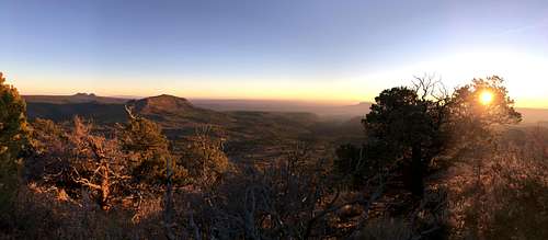
Bears Ears Mesa
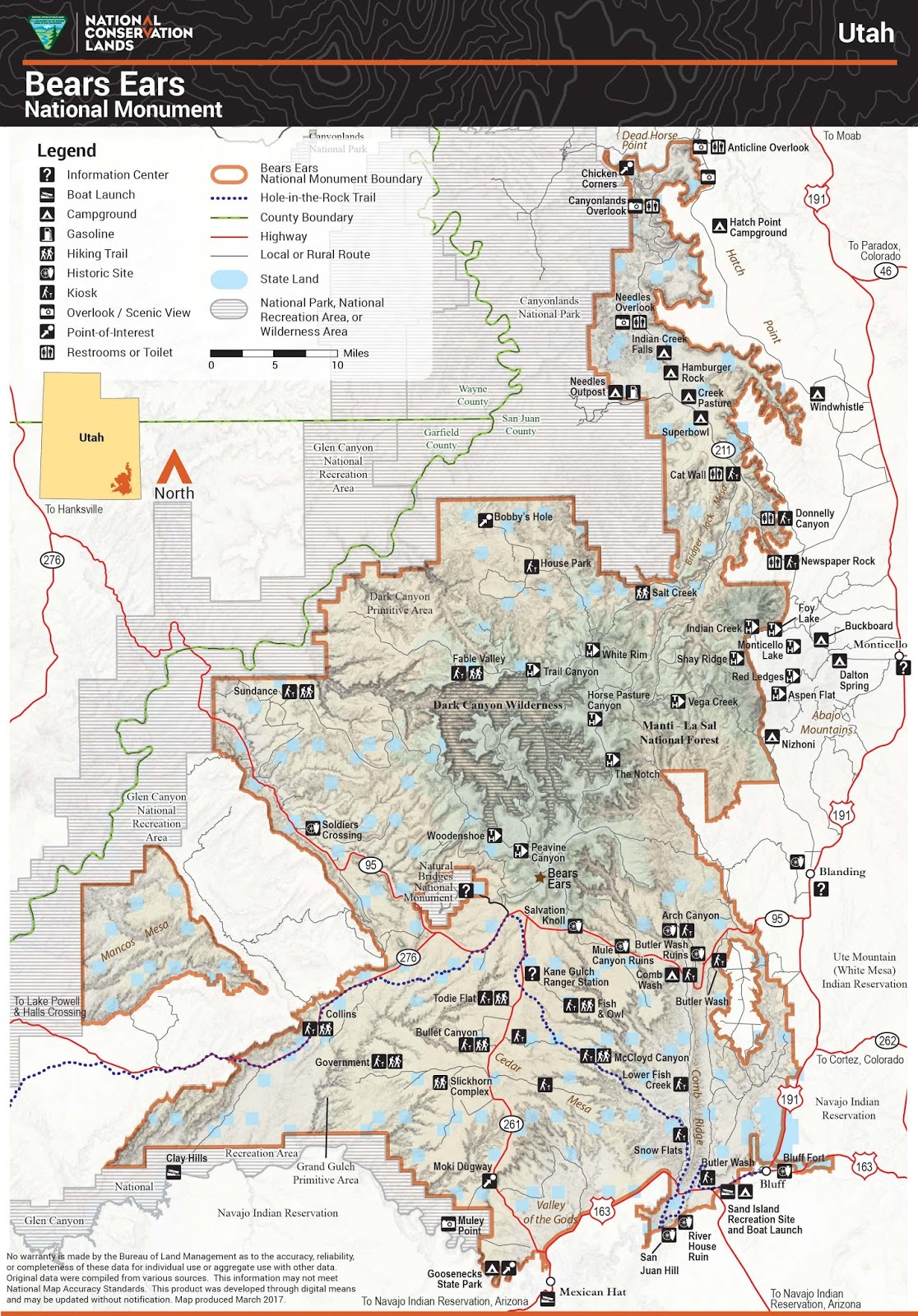
It is composed of several key sections.
Valley of the Gods - Towering desert sandstone towers rivaling those of Monument Valley to the south in height and number.
Cedar Mesa - An elevated expansive of endless canyons rimmed by pinon and juniper pines and chalked full of priceless archaeological sites belonging to a host of ancient Native Americans, most notably of which are the Anasazi.
Bears Ears Buttes - The iconic buttes sit atop a raised mesa covered in meadows and ponderosa forests. The Woodenshoe Buttes (The Toe and The Heel) are located 6 miles to the northwest on this mesa.
Dark Canyon - A remote labyrinth of canyons, mesas, and buttes that extends from the western slope of the Abajo Mountains to the Colorado River.
Indian Creek - Boasts the premier crack-climbing area of the entire world with thousands of cracks in Windgate Sandstone often over a hundred feet high. It is also home to the famous petroglyph mural known as Newspaper Rock.
Red Tape
Drilling, mining, fracking, and other extraction industries are banned within the monument. Hiking, climbing, cattle grazing, firewood cutting, herb gathering are all preserved as part of the cultural aspect of the area that deserves protection. The intricacies of the management plan continue to be ironed out.Climbing at Indian Creek does not require permits.
Hiking most of the Bears Ears doesn't require permits. However, depending on the canyon, a permit may be required, due to the priceless archaeological sites they often contain.
External Links
US Forest Service - Bears Ears National Monument
Utah Dine Bikeyah - A Native American-led "501(c)3 nonprofit organization that works toward healing of people and the Earth by supporting indigenous communities in protecting their culturally significant, ancestral lands."
Bears Ears Inter-tribal Coalition - "A historic consortium of sovereign tribal nations united in the effort to conserve the Bears Ears cultural landscape."
Human History
The following is from the Presidential Proclamation –Establishment of Bears Ears National Monument. It is one of the best summaries inexistence.
The area's human history is as vibrant and diverse as the ruggedly beautiful landscape. From the earliest occupation, native peoples left traces of their presence. Clovis people hunted among the cliffs and canyons of Cedar Mesa as early as 13,000 years ago, leaving behind tools and projectile points in places like the Lime Ridge Clovis Site, one of the oldest known archaeological sites in Utah. Archaeologists believe that these early people hunted mammoths, ground sloths,and other now-extinct mega fauna, a narrative echoed by native creation stories.Hunters and gatherers continued to live in this region in the Archaic Period,with sites dating as far back as 8,500 years ago.
Ancestral Puebloans followed, beginning to occupy the area at least 2,500 years ago, leaving behind items from their daily life such as baskets, pottery, and weapons. These early farmers of Basketmaker II, and III and builders of Pueblo I, II and III left their marks on the land. The remains of single family dwellings, granaries, kivas, towers, and large villages and roads linking them together reveal a complex cultural history. "Moki steps," hand and toe holds carved into steep canyon walls by the Ancestral Puebloans, illustrate the early people's ingenuity and perseverance and are still used today to access dwellings along cliff walls. Other, distinct cultures have thrived here as well-- the Fremont People, Numic- and Athabaskan-speaking hunter-gatherers, and Utes and Navajos. Resources such as the Doll House Ruin in Dark Canyon Wilderness Area and the Moon House Ruin on Cedar Mesa allow visitors to marvel at artistry and architecture that have withstood thousands of seasons in this harsh climate.
The landscape is a milieu of the accessible and observable together with the inaccessible and hidden. The area's petroglyphs and pictographs capture the imagination with images dating back at least 5,000 years and spanning a range of styles and traditions. From life-size ghost like figures that defy categorization, to the more literal depictions of bighorn sheep, birds, and lizards, these drawings enable us to feel the humanity of these ancient artists. The Indian Creek area contains spectacular rock art, including hundreds of petroglyphs at Newspaper Rock. Visitors to Bears Ears can also discover more recent rock art left by the Ute, Navajo, and Paiute peoples. It is also the less visible sites, however --those that supported the food gathering, subsistence and ceremony of daily life-- that tell the story of the people who lived here. Historic remnants of Native American sheep-herding and farming are scattered throughout the area, and pottery and Navajo hogans record the life ways of native peoples in the 19th and 20th centuries.
For thousands of years,humans have occupied and stewarded this land. With respect to most of these people, their contribution to the historical record is unknown, but some have played a more public role. Famed Navajo headman K'aayélii was born around 1800 near the twin Bears Ears buttes. His band used the area's remote canyons to elude capture by the U.S. Army and avoid the fate that befell many other Navajo bands: surrender, the Long Walk, and forced relocation to Bosque Redondo. Another renowned 19th century Navajo leader, "Hastiin Ch'ihaajin" Manuelito, was also born near the Bears Ears.
The area's cultural importance to Native American tribes continues to this day. As they have for generations, these tribes and their members come here for ceremonies and to visit sacred sites. Throughout the region, many landscape features, such as Comb Ridge, the San Juan River, and Cedar Mesa, are closely tied to native stories of creation, danger, protection, and healing. The towering spires in the Valley of the Gods are sacred to the Navajo, representing ancient Navajo warriors frozen in stone. Traditions of hunting, fishing, gathering, and woodcutting are still practiced by tribal members, as is collection of medicinal and ceremonial plants, edible herbs, and materials for crafting items like baskets and footwear. The traditional ecological knowledge amassed by the Native Americans whose ancestors inhabited this region, passed down from generation to generation, offers critical insight into the historic and scientific significance of the area. Such knowledge is, itself, a resource to be protected and used in understanding and managing this landscape sustainably for generations to come.
Euro-Americans first explored the Bears Ears area during the 18th century, and Mormon settlers followed in the late 19th century. The San Juan Mission expedition traversed this rugged country in 1880 on their journey to establish a new settlement in what is now Bluff, Utah. To ease the passage of wagons over the slick rock slopes and through the canyon lands, the settlers smoothed sections of the rock surface and constructed dugways and other features still visible along their route, known as the Hole-in-the-Rock Trail. Cabins, corrals, trails, and carved inscriptions in the rock reveal the lives of ranchers, prospectors, and early archaeologists. Cattle rustlers and other outlaws created a convoluted trail network known as the Outlaw Trail, said to be used by Butch Cassidy and the Sundance Kid. These outlaws took advantage of the area's network of canyons,including the aptly-named Hideout Canyon, to avoid detection.