
|
|
Mountain/Rock |
|---|---|
|
|
47.73562°N / 121.28165°W |
|
|
King |
|
|
Hiking, Mountaineering, Trad Climbing, Scrambling |
|
|
Spring, Summer, Fall, Winter |
|
|
5062 ft / 1543 m |
|
|
Overview
Beckler Peak is a mountain located in the southeastern region of Wild Sky Wilderness of Washington. The peak has both local historical importance and is the site of some peakbagging controversy. Although basically considered as a non-technical ascent, Beckler Peak also has terrain for technical mountaineers and rock climbers to enjoy.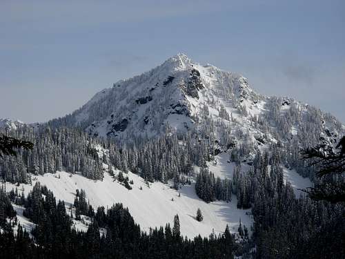 Mount Fernow (6190' elevation) as seen from Beckler Peak
Beckler Peak was named in honor of Elberdge H. Beckler, a railroad engineer who worked for the Great Northern Railway during the late 1800s. Beckler also helped extend the Milwaukee Railroad into the area. Beckler River, located west of the mountain, was also named in honor of Elberdge H. Beckler, in 1892. The mountain then became the site of a fire lookout during 1924, a 25' tall pole tower with a 6' x 6' log cabin, before the lookout was retired when it was detroyed in 1958. The fire lookout did not sit on any of Beckler Peak's several highpoints, but actually was stationed at 4950' elevation just below the west summit so it would have an optimal location to oversee the town of Skykomish and the Beckler River/Skykomish River confluence.
 Ascending Southeast Slope...
Beckler's Multiple Highpoints: Which Is Highest?
Beckler Peak is also the source of some local peakbagging controversy. The peak has at least four different highpoints, all nearly equal in elevation. The East Peak has one 5062' contour and the other three contenders (including the Middle Peak's definitely-shorter sub-peak) each have 40-foot contours for elevations between 5040'-5080'. That suggests there are possible vertical differences of less than 22' elevation between each of those possible "highest" points of the Beckler Peak ridgeline.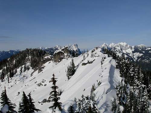 West Peak, Middle Peak, and snowy Middle Peak sub-peak
Most people claim a successful summit of Beckler Peak by virtue of only reaching the East Peak, not only because it is the easiest peak to summit but also because it is the named "Beckler Peak" location on official maps and where the USGS Benchmark has been located. Technical rock climbers placed a summit register on the highest of the two Middle Peaks years ago, although very few climbing parties have actually signed that register. The West Peak, near where the old lookout site was located, also has a summit register. The reality is that each highpoint along the Beckler Peak ridgeline is a worthy mountaineering objective. To each his or her own.
 Looking at the West Peak and its southern slopes...
During September 2011, Eric Willhite contributed to this page a 10-Foot Contour topography (LIDAR) map for Beckler Peak. That map shows the West Peak as being definitively lower than the Middle and East Peaks, although the Middle and East Peaks each have the same elevation within a 10-Foot Contour. Using that map as a reference, the Middle and East Peaks are the only true logical contenders for highest points. But their respective elevations are so similar that either might be truly higher than the other, or perhaps they are the same elevation.
 10-Foot Contour Map (Provided By Eric Willhite)
During 2013, one climbing party (Greg Slayden, Edward Earl) used a sight level which implied that the western of the two Middle Peaks is the highest point of the ridgeline by only a few feet in elevation. They referred to the higher western Middle Peak as a monolith while the eastern Middle Peak was referred to as a fin. As a result, the Peakbagger.com website added a "Beckler Peak Central" mountain to its database for this location.
If accurate, it begs the question of why the East Peak has always been the officially named highpoint. One logical reason might be because the East Peak looks higher from the south (i.e. populated areas), but no concise reason is known. Another reason is that rudimentary methods might have been used when compared to current technologies for determining elevation.
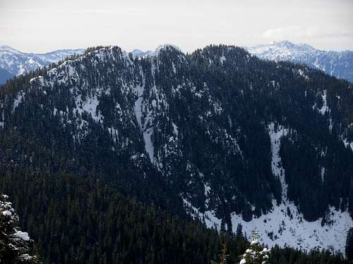 Beckler Peak, as seen from Alpine Baldy
Getting There
The standard routes for this summit, including driving directions, hiking directions, and parking areas, have changed multiple times during the years following the creation of Wild Sky Wilderness. The following directions have been updated, but if any other changes/revisions occur please notify the page administrator.From Skykomish, WA:
1) Drive east along Highway 2 for 3.1 miles.
2) Turn left onto FS-6066.
3) After 1.8 miles, the road splits. Take the right fork (uphill) to continue on Forest Road 6066.
4) Follow to the end of the road (6.7 miles total from Highway 2). This is the "Jennifer Dunn Trailhead" (~2700' elevation) for the Beckler Peak Trail.
------------
HIKING DIRECTIONS:
1) Begin hiking along the decommissioned sections of FS-6066, heading east.
2) Follow the overgrown logging road for 1.6 miles to a trail junction (~3600' elevation).
3) Turn onto the trail, and follow it for 2.1 miles to the East Peak summit. From the overgrown road, the trail angles uphill towards the saddle connecting Beckler Peak and Alpine Baldy, then follows the ridgetop westward to the summit.
4) For the Middle Peak, continue heading west on the upper south-facing slopes from the East Peak. Several rocky outcrops stand near the Middle Peak location, but the tallest one is a technical ascent and the use of rock climbing equipment (rope, harness, etc.) is strongly desired.
5) For the West Peak, head west and down-slope several hundred feet in elevation on the south-facing slopes below the Middle Peak, then after passing the Middle Peak rocky area begin ascending upslope to the forested West Peak, which is non-technical.
Hiking to the East Peak summit is approximately 7.4 miles roundtrip. Hiking time is typically between 4-6 hours roundtrip.
------------
PRIOR TO AN OFFICIAL TRAIL BEING IMPLEMENTED, HERE WAS THE FORMER ROUTE:
1) Begin hiking along the decommissioned sections of FS-6066, heading east.
2) Within 0.5 miles, at the first road fork intersection, the apparent main road sharply switchbacks left (northwest) while overgrown FS-6066 continues straight ahead. Take the left branch road that heads northwest. The road quickly becomes overgrown as it ascends northwest until reaching a stream/washout at approximately 3350' elevation.
3) Cross the stream, heading west and leaving the old road. Then steeply ascend northwest up thick forested slopes until reaching the eastern ridgetop of Beckler Peak at approximately 4400' elevation.
4) Once on/near the ridgetop, begin heading west to the East Peak (5062' elevation), which requires a steep final ascent but is non-technical.
Hiking the former route to the East Peak summit was approximately 5.0 miles roundtrip. This route is no longer recommended due to the implementation of an official trail, but is still described here for historical purposes.
Hiking time was typically between 4-6 hours roundtrip.
------------
There are other approaches for Beckler Peak, as well, such as via its southwest slopes or via an approach from its neighbor-peak Alpine Baldy. The southwest slopes are commonly used for summiting the West Peak and occasionally also the Middle Peak. Some climbing parties also carefully reach the Middle Peak(s) from the East Peak.
Red Tape
As of 2011, an official trail has been constructed for Beckler Peak. The trailhead is named "Jennifer Dunn Trailhead". Despite being an official trail, according to the U.S. Forest Service the use of a Northwest Forest Pass (parking permit) is not yet required (but recommended).Camping
Backcountry camping is allowed on Beckler Peak and within Wild Sky Wilderness.Please contact a local ranger station, such as Skykomish Ranger Station, for further details.