
-
 13521 Hits
-
 90.48% Score
-
 32 Votes
|
|
Mountain/Rock |
|---|---|
|
|
58.23293°N / 4.4165°W |
|
|
Sutherland |
|
|
Hiking |
|
|
3153 ft / 961 m |
|
|
Overview
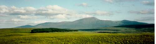
Ben Klibreck is one of the most isolated Munros/Murdos in Scotland, a sprawling mass sitting in the middle of Sutherland’s moorland. The name Ben Klibreck means the hill of the speckled stone and refers to the higher parts of the 12km ridge which arches between Lock Naver and Loch Choire. The summit ‘Meall nan Con’ stands at 961 meters above sea-level which currently places it at number 194 on the Munro list and 288 on the Murdos listIt has to be said that Ben Klibreck is one of the most featureless with no real variation on the theme of heath, whichever route you go. The western slopes are generally steep consisting of
 Little did my wife know, but when she took this picture I was practicing my lines for the biggest question in my life. Thankfully she said yes
For me this mountain is very special. I was conceived within its shadow, and proposed to my wife at its summit. On one occasion whilst sitting on the top eating our sandwiches we were joined by a couple of golden eagles who then soared effortlessly in the wind.
Below I have outlined the main routes, the books listed below and the website links supply further detail.
This is my first page on Summitpost so please feel free add your pictures and send any comments through. I will be adding more pictures as/when they are scanned.
 Fabulous views looking east from the Summit. Ben Hee to the right, Loch Shin in the distance. The routes from the Crask Inn and Vagestie can easily be traced. This pic was a gift from Mike and Kai the owners of The Crask Inn the day we got engaged on their mountain
Getting There
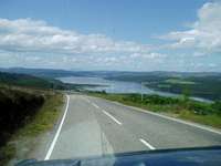 Ben Klibreck in the distance from the view point at Struie on the B9176
 Single track roads with passing places
 Road Map to Ben Klibreck
By Car/Bike: If traveling from the south follow the A9 north until Tain, once past Tain either turn left onto the A836 to Bonar Bridge, or continue on the A9 across the Dornoch bridge and then turn left onto the A949 to Bonar Bridge, there are ruins of an old mill at Spinningdale. For a less monotonous route with spectacular views take the B9176 to Bonar Bridge just northeast of Evanton. If the weather is good you will easily see Ben Klibreck from the viewing point on Struie Hill (see pic). At Bonar Bridge continue on the A863 to Lairg where there are shops and a Petrol station. There are very few Petrol stations in the region so if in doubt fill up here. Pass through Lairg following the signs to Altnaharra and Tongue. 10 miles north of Lairg is The Crask Inn where there is accommodation and from where the first route starts.
Please note that 3 miles north of Lairg the roads are single track with passing places. Remember to let traffic behind you pass too, the locals will not take it kindly if you don’t! There are deep ditches at the sides and some large drops. I once had to tow a group of Chezchs out before I could get home which earned me a very nice bottle of their white wine. En-route you will note a lot of tree felling, if in a 4x4 some of forest roads were open for exploration, although strict adherence to the safety notices and the use of a 1:25000 map is paramount, Sat Nav doesn’t work!
If traveling from the north there are three routes. From Loch Eribol, take the unclassified road at the north end of Loch Hope to Altnaharra, a very spectacular route and one from which Ben Hope can be climbed. From Tongue take the A863 south to Altnaharra; look out for the Canada geese on Loch Lloyal. From Bettyhill follow the A836 for ~2 miles then turn left onto the A871 to Syre, at Syre, (the Chapel with white walls and the red roof), continue straight onto the B873 signposted Altnaharra. The Caravan Club site at Grummore is 9 miles along this road. Continue to Altnaharra. Between Altnaharra and The Crask Inn are a number opportunities to park and take a route up Ben Klibreck.
By Train: the nearest Train Station is Lairg station, which is situated 2 miles outside of Lairg itself and not surprisingly there is no taxi rank. If you need a taxi there are local firms, however pre-booking is essential. Once in Lairg there is a Post bus which can drop you off en-route, but check the times as when I was last there it only ran 3 days a week.
By Helicopter: It is possible to arrive at the Altnaharra Hotel by helicopter although pre arrangement is necessary as parking places are limited.
OS Grid: NC 569 351
Lat: N 58.16.55
Lon: W 004.26.26
Nat Grid: 256 935
Routes
Do not underestimate the remoteness of this mountain, it is recommended that you do not travel on your own, although there are mobile phone masts, one above Altnaharra the other on The Crask hill the signal is sporadic. There are no known local rescue teams and certainly no local air rescue.Most routes are climbed and then reversed as the circular routes tend to be very long. The paths in general are not well defined and in most cases simply do not exist. Therefore a map and compass are essential.
All times quoted are approximate and should only be used as a guide. The actual times will vary considerably due to weather, ground conditions and the ability of the group etc.
To make it a full day why not include Ben Loyal and/or Ben Hope.
 The Ridge of Ben Klibreck with the summit Meall nan Con in the middle
From Grummore Caravan Club Site – NC610367 – About 5 hours – Not in any of the books!
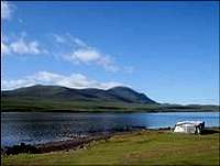 Looking across to Ben Klibreck from the Grummore caravan site
Sail/Canoe/Row/Swim across Loch Naver, (outboards are not permitted), there are a number of possible landings some sandy, the most convenient is to the SE side of the Broch NC605355 and will be the easiest to find on the way back. Whilst there why not pay a visit to an iconic symbol of Scottish history. There are no paths this side until you reach the ridge and the ground is extremely uneven with hidden burns (streams). Once across head SSE towards NC621319 the saddle between Meall Leathad na Craoibhe (The Whip) and Meall Allein. This takes a lot longer than expected as what looks like a gentle rising hill has a long shallow dip before rising steeply and the terrain is hard going. An easier and less arduous route is to follow the stream from NC613359 to the hut circles and then up onto Round Hill, then onto the ridge via Ceann na beinnie Bige or straight onto Meall Leathad na Craoibhe, although this stream is dangerous when in spate. Once at the saddle follow the clearly defined ridge to the top. The ridge from Meall Meadhonach can look quite imposing in the mist. Decent is a matter of reversing the route up or a more direct route heading straight for the Broch is possible. My favourite and you will not find it in any of the guide books!
 Looking across Loch Naver to the Ben Klibreck ridge
From Vagastie – NC546304 – The most common and possibly
 The waterfall at Vagestie
There are various starting points for this one indicated by several small rough parking places along the A836. The one I did starts from the small conical shaped mound which hides a beautiful waterfall behind it. Cross the river and head East to the south end of Loch na Glas-choille NC558302, follow the fence line to the outflow of Loch nan Uan NC568297. You are now at the steep grassy face of Ben Klibreck. The easiest route is to head ESE onto the main ridge NC5763292. Once up continue up the ridge to the summit Meall nan Con. A common alternative is to start from NC537289, cross the river and head E to the south of Loch Bad an Loch, then slightly North of E to the south of Loch nan Uan NC566289 and climb onto the ridge as before. Decent is commonly a matter of reversing the same route.
 Looking across Vagestie to the Ben Klibreck Ridge
From the Crask Inn – NC533247 – Long circular
 The Crask Inn
There are almost any combination of routes starting from the Crask Inn,one of them follows a long slowly rising ridge the other follows the 25 mile route to Kimbrace through Srath a’ Chraisg to Loch a’ Bhealaich and/or onto the shores of Loch Choire. From the Crask Inn head down the road for 200 meters until you see a boggy track to your left NC524246. For the ridge route (shortest) head NE to the cairns on Cnoc Sgriodain NC552271 from there head ENE onto Creag an Lochain NC576281 and then along the clearly defined ridge to the summit. The alternative route(s) and by far the longest. Head E along a boggy but clearly defined track through Srath a’ Chraisg and onto/through Bealach Easach NC578252, where you will be greeted by a fabulous view through the valley and over Loch a’ Bhealaich and if not too misty Loch Choire is visible in the distance. The path to Kimbrace continues to the NW side of the Loch and onto Loch Choire. There are numerous options to choose on when/where to start climbing Klibreck. One suggestion is to continue through to Loch Choire NC627285 and then head NNW to the monument at NC619305, from here head NW to Meall Ailen and then follow the ridge SW to the summit. Popular circular options are to descend the ridge to the Cairn on Cnoc Sgriodain and then either onto Vagestie Bridge or directly to the Crask Inn.
From Vagastie Bridge NC532270 – Easiest ~
 View from Vagestie Bridge
 On the way to Cnoc Sgriodain
From the Crask Inn travel up the hill, round the top and descend until you see the bridge over Vagestie. 200m beforehand on the LHS you will notice a small area for parking cars. Cross the road and head E across long grassy slopes to the cairn on Cnoc Sgriodain NC552271. The last time I did this route there was a track made by a vehicle, which made walking through the grasses much easier. From the Cairn follow the ridge down and then up onto Creagan Lochain NC576281. The ridge then heads north dropping slightly and then turns NE to climb to the summit. Decent is usually the reverse.
From Klibreck Farm – Extract from ”The Northwest Highlands” by D.J. Bennet & T.Strang (SMC)
(I myself have not done this one so have taken the extract from the Scottish Mountaineering Club District Guide)
“As one approaches Altnaharra turn east down the rough motor road sign posted “Klibreck Farm’. This can be followed for one and a half kilometers along the south shore of Loch Naver to the farm buildings, whence a path is followed across a ford just past the shepherd’s house. This is indistinct to start with, but the line soon becomes well marked, and a good track leads directly up steep heathery slopes onto the flat summit of Meall Ailein (724m), on the north-east end of the ridge. A monument is found at the end of the spur which goes out in a south-easterly direction towards Loch Choire; a memorial to crashed airmen. The traverse of the ridge now develops into a pleasant walk along broad, richly vegetated slopes, with a stiffer pull onto the summit. Just below the trigpoint a substantially built stone shelter is found rather unexpectedly on the south-east side of the ridge. From this point the broad central spur of Ben Klibreck pushes out south-eastwards towards Loch a’Bhealaich, terminating in Meall an Eoin (774m). From the Munro top, the main ridge continues for another 2km onto Creag an Lochain (808m). From there, it is best to return to the saddle leading back to Meall nan Con and pick a way down the heathery western slopes to Loch nan Uan. A faint path can be followed back to Klibreck Farm to complete a fine 15km circuit” pp327/8
From Loch Choire Lodge – NC652304
I have heard it is possible to start from The Lodge at the NE end of Loch Choire, although I do not know what the accessibility rights for this is so check beforehand.
The route starts by following the track over the loch outflow and then onto the boggy track until about half way round the NW side. Head NW to the monument at NC619305, from here head NW to Meall Ailen and then follow the ridge SW to the summit. A should be possible to make this a circular route through Bealach Easach NC578252 and then follow the path to the NW of Loch a’ Bhealaich and onto Loch Choire
Wee beasties and the weather
Midge and his army. If you are in anyway allergic to the bites of Midges, then do not climb when there is no wind or during the months of July and August when they are at their best. Midges would appear to be immune to most repellents, although folk law has it that they hate the smell of rum, which I am told exudes from the pours of your skin after being drunk (not recommended!). It would also appear that they are attracted to dark clothing.Clegs. Even if you are immune to the effects of the midge, then you will certainly suffer at the proboscis of the Cleg. These are winged scorpians, you will not be aware of them landing on you even though they are around 15mm long, however you will certainly be notified of their presence when they bite. These rude beasties do not have the cunning to have an anaesthetic in their saliva and so you will know when they have had a drink.
If crossing Loch Naver check the forecast for wind as I have seen 4 foot swells develop very quickly which makes the crossing very difficult and potentially hazardous. Thunder Storms can develop very quickly and the wind whips up the loch from Altnaharra.
Ben Klibreck readily holds the cloud for the whole day even when the rest of the surrounding area is completely clear.
Maps and Books
OS Explorer 443OS Explorer 447/8 (If approaching from the North)
Munro and Corbet Chart by Harvey Map services Ltd
The Northwest highlands by D.J Bennet and T.Strange
The Munros edited by D.Bennet
The Munros: Scotland's Highest Mountains by Cameron McNeish
Accommodation
The Crask Inn - Crask:To do it properly you have to stay at the Crask Inn. Owned and run by Mike and Kai it's situated 10 miles north of Lairg on the A836, pre booking is recommended. There is B&B accommodation as well as a self catering bunkhouse with 12 beds. Food is fabulous, all local and freshly cooked, fabulous atmosphere and very friendly! A good traditional rustic Inn, which in my opinion is a must for all Munroists. At least stay for a pint.
The Altnaharra Hotel - Altnaharra:
For the more affluent and those requiring creature comforts or the true Scottish game experience there is the Altnaharra Hotel.
Camping and Caravaning
There is a Caravan Club site at Grummore (members only and doesn’t take tents)
There is the Dunroamin Caravan & Camping Park just outside Lairg
A number of other private campsites, holiday homes etc are available in the locality.
External Links
http://www.touristnetuk.com/sc/nwhighlands/accommodation/ac-camp/lairg.htmhttp://www.caravanclub.co.uk/Planning+Your+trip/UK+Trips/Site+Search+and+Book/Club+Sites/Site+Detail.htm?csid=GRUMMORE
http://www.letsgonorth.com/scripts/view.pl?27
Walkers accounts and routes
http://www.jbutler.org.uk/e2e/csw/w9/index.shtml
http://www.inspiration-kelso.co.uk/tr/ben_kilbreck/