
-
 3455 Hits
-
 74.92% Score
-
 5 Votes
|
|
Route |
|---|---|
|
|
46.44161°N / 12.64338°E |
|
|
Hiking, Scrambling |
|
|
Spring, Summer, Fall |
|
|
Half a day |
|
|
medium hard hike up |
|
|
Rating The Tour (By Hiking Standards)
Gear (in dry seasons): Only good shoes and poles. For the road (1 h on foot) from Casera di Razzo to Casera Chiansaveit a bike is recommended.
1. Effort. 800 m, 3 h (from Casera Chiansaveit 2 h).
2. Power. 1 - no difficulties, only walk-up.
3. Psyche. 3 - medium.
4. Orientation. 1 - no difficulties (all the time good marked paths).
The grading system for hiking and scrambling routes is here.
Overview
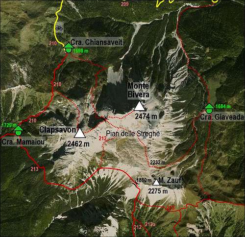
A very nice route on one of the most panoramic summits of Southern Carnic Alps. Due to the high starting point the tour is short and can be done in half of a day. It is highly recommended to combine the summits of Monte Bivera and Clapsavon in one round tour.Getting There
See the main page of Monte Bivera and its parent pages how to get to Casera di Razzo!Route Description
From Casera di Razzo we walk some 1 h to Casera Chiansaveit. By bike it can take considerably less.From the hut of Chiansaveit we go by the path No. 212 a bit further towards the SE, till the end of the meadow. There a good path enters the larch forrest and soon starts crossing the northern slopes of Monte Bivera towards the East. It ascends only slowly. Only when reaching the northern ridge of Monte Bivera, which comes down on the bump of Monte Rigoladis, 1738 m, the path turns right and ascends more and more steeply towards the south. On the left we first see down on the big scree slopes (Sabbie Bianche), then we ascend through one or two passages between interesting bumps and reach the grassy slopes, which end above in the high valley between Monte Bivera and Clapsavon.
 Above Casera Chiansaveit |  Monte Bivera N slopes |  A short rest half way up |

The scree valley below Forcella del Bivera

Towards the summit
The path below the western ridge is at first quite steep, we scramble a little, taking care to choose the best passages. From the altitude of 2345 m the marked path continues crossing the southern slopes, but it is more advisible to ascend left up and gain the main ridge. In both cases we have to scramble a bit. Later it gets easier and on a small, grassy col both variants join. We are just below the summit rocks. We keep a bit right and in a short and easy climb/scramble (UIAA I-) we are soon on the top.