
-
 10531 Hits
-
 74.92% Score
-
 5 Votes
|
|
Route |
|---|---|
|
|
35.93097°N / 115.04319°W |
|
|
Hiking |
|
|
Spring, Summer, Fall, Winter |
|
|
Half a day |
|
|
Overview
 Elevation Profile
Getting There
1. From Las Vegas drive South on I-15.2. Take exit 34 onto 215 East toward McCarran Airport.
3. Drive 5.7 Miles to the Eastern Ave. Exit (Exit 5)
4. Take Eastern Ave. South for approximately 3.0 miles
5. Merge left onto Anthem Pkwy for 2.4 miles
6. Take a left onto Atchley Dr.
7. Drive for 0.4 miles Atchley Dr. and then turn left onto
Shadow Canyon Dr.
8. Drive for 0.6 miles on Shadow Canyon Dr. Just past the 2200 Block
you will pass Lewiston Pl. on your left then after the 1st house you
will see a small parking area for about 6 vehicles. This is where
you park.
Waypoints
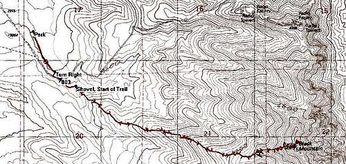 GPS Trace
WPT 1 35°56'42.7"N, 115°4'53.3"W
WPT 2 35°56'25.4"N, 115°4'42.6"W
WPT 3 35°56'22.0"N, 115°4'39.6"W
WPT 4 35°56'19.0"N, 115°4'31.8"W
WPT 5 35°55'51.6"N, 115°2'38.6"W
Descriptions
WPT 1 Park
WPT 2 Turn Right up the road - 0.39 miles, 3,040 feet
WPT 3 Trail - (short dirt trail before more cement) - 0.51 miles, 3,090 feet
WPT 4 Shovel, start of main Trail - 0.67 miles, 3,090 feet
WPT 5 Summit, 3.00 miles, 5,092 feet
Route Description
From the Parking area start Hiking South along the pavement. (Elevation 2982 feet). Hike for about 0.39 miles and you will see a little road to your right off of the one you are walking on. Turn right up this road and follow it around to the short dirt trail that starts. Then after the dirt ends back up on the cement again, turn left and go down a short distance until you see the shovel marking WPT 4, the start of the main trail up the NW ridge to the summit. |  |  |  |  |
From the shovel it is a nice maintained class 2 trail all the way to the summit. It gets steep towards the end. In the spring there is a variety of vegetaion. Towards the end it gets steep.
The route covers 3 miles and about 2100 feet of elevation gain.
To return retrace your steps.
lasvegaswraith - Feb 8, 2010 9:34 pm - Hasn't voted
UpdateQuick update to the trailhead location Jan 2010, with all the building in Anthem. The 6 spot parking lot is still there. The road is now a paved multiuse trail that carries throughout the neighborhood. Stay on the paved trail as indicated in the description towards the concrete stepped retention basin that is visible to the east. Make your way behind the building at its edge and around the south and east edge of the retention basin to the new marked trailhead.