
-
 2831 Hits
-
 70.59% Score
-
 1 Votes
|
|
Route |
|---|---|
|
|
47.97710°N / 6.99000°E |
|
|
Hike |
|
|
Most of a day |
|
|
Walk-up |
|
|
Overview
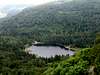
This nice walk leads you on 3 over 1300 meters peaks of the Vosges, the Rainkopf, the Rothenbachkopf and the Batteriekopf. You discover also the lonely and quiet Blanchemer Lake and the wild peat-bogs of the Machais Pond
 |  |
Approach
The Blanchemer Lake can be reached from La Bresse or Le Collet with the road D34d. At Pont de Blanchemer, take the Chemin de Blanchemer (forest trail). Park just before the lake.
Route Description
Follow the lake's north bank, pass near the shelter hut and take the path marked with blue triangles. Turn left and use the Chemin du Grand Bougre. After 500 m, climb right to the crest.
Follow the crest in southern direction and climb on the top of the Rainkopf. From here you can admire your target, the Rothenbachkopf in the south with his steep east face. The climb follows the crest but you must first walk down to the point 1205 m near the Route des Crêtes.
Continue your crest walk to the summit of Batteriekopf. 300 meters after this summit, turn blutly to the right and walk back to the Rothenbachkopf collar with the path below the crest on the west face.
Follow the red-white-red marks until you reach the path cross. Turn left and use the path with blue rectangle marks to the Col de l'Etang (pond collar). Here, turn right (red triangles) to the Etang de Machais (pond between peat-bogs). Cross the forest road. The red triangles along the Chemin des Italiens will conduct you back to the Blanchemer Lake.
 |  |  |  |
Essential Gear
No gear is necessary
Red Tape
Machais Pond is a natural reserve.