
|
|
Mountain/Rock |
|---|---|
|
|
47.51378°N / 121.72423°W |
|
|
King |
|
|
Hiking, Mountaineering |
|
|
Spring, Winter |
|
|
4593 ft / 1400 m |
|
|
Overview
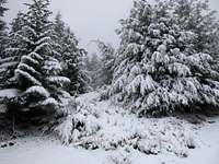 Forested Slopes On Blowdown Mountain
Blowdown Mountain is a seldom visited summit found along the same ridge as Mount Si and Mount Teneriffe, in Washington State. Although located between Mount Si and Mount Teneriffe, Blowdown Mountain is often overlooked and underappreciated. By being centrally located between Mount Si and Mount Teneriffe, Blowdown Mountain offers a unique vantage point of those peaks. The west side of the mountain is heavily forested, while the east side of the mountain is sporadically forested (perhaps giving "Blowdown" its name). An evergreen forest surrounding the summit partially obstructs views, but the upper slopes on the east and south sides of the mountain provide great viewpoints of peaks both near and faraway. The dense evergreen forest on the peak helps give the mountain its special charm on the ridge when compared with forests on neighboring peaks. However, the lack of 360° views (or even 180° views) from any one place at the summit area makes this purely a peakbagger's peak; nothing more, nothing less.
 Southeast Slopes
As a result of underbrush growing thick on the peak during most of the year, Blowdown Mountain is typically best traversed during winter months and other periods of snowcover. Summiting Blowdown Mountain does not require a technical climb. However, finding the true summit of Blowdown Mountain can be difficult due to a semi-flat top, especially when snow drifts cover much of the mountaintop.
Blowdown Mountain is also known as Point 4560+ or Peak 4560+, as its official summit elevation has been debated as ranging between 4560' and 4600' (i.e. 40' closed-contour). However, while at the summit on March 4, 2009, I reviewed the "TOPO U.S. - West Coast & Hawaii" microSD map for my Garmin "eTrex Vista Cx" GPS device, and then took several readings using my altimeter. Both the map and altimeter showed the summit area as 4593' elevation, which will be used for the purposes of this SummitPost page until/unless more official information to the contrary can be provided later.
There are two main options for reaching the summit:
For the first option, the "Fire Road" (Mount Teneriffe Road-Trail), originating at the "School Bus Turnaround" parking area, provides the most direct option for summiting Blowdown Mountain. At approximately 4000' elevation along the "Fire Road", the road turns sharply north. Near this location, an abandoned logging road heads northwest, ending due south of the summit at approximately 4420' elevation.
Total distance from the "School Bus Turnaround" parking area to the Blowdown Mountain summit is approximately 6.0 miles, one-way.
For the second option, the Southwestern Ridge Approach, originating from the Mount Si Trail, provides a shorter but more difficult option for summiting Blowdown Mountain. Follow the Mount Si Trail to the Haystack Scramble. Continue following the trail heading east from the Haystack Scramble, for 0.5 miles (approximately 3900' elevation). Near this location, the trail begins descending (eventually intersecting the "Fire Road"). Shortly after heading downhill, turn to hiker's left (north), enter the dense forest, and follow the ridge northeast. Once the steep southwestern slope of Blowdown Mountain is reached, begin climbing steeply uphill, through a dense evergreen forest, until the summit is attained.
Total distance from the Mount Si Trail parking area to the Blowdown Mountain summit, via the Southwestern Ridge Approach, is approximately 5.25 miles, one-way.
Getting There
VIA FROM I-90:Take Exit 32. Go north one mile where the road intersects North Bend Way. Make a left (west) on North Bend Way towards North Bend. After driving about a 1/4-mile, take a right on the Mount Si Road. From this road, use driving instructions for desired summit approach:
FOR "FIRE ROAD" APPROACH:
Take the Mount Si Road approximately 1 1/4 mile past the Mount Si trailhead (The New Trail) to the school bus turnaround area. On your left is a blocked fire road. Park here but make sure not to block entrance. Also make sure not to park here during school days until after 5:00 PM.
FOR MOUNT SI TRAIL APPROACH:
Park at the Mount Si Trail parking lot.
Red Tape
Beginning during 2011, parking areas and trailheads within and for the Mount Si Natural Resources Conservation Area (NRCA) require a Discover Pass to be in each vehicle during the visit. Failure to have a Discover Pass visible within a parked vehicle at these locations can result in a substantial fine. For more information regarding the Discover Pass, please visit the official website.Parking at the "School Bus Turnaround" area is not allowed on school days between 8:00 AM and 5:00 PM.