Background
Because I'm moving out of the east coast in a month, I wanted to finally hit the famous presidential traverse - what many consider an epic and maybe most scenic hike of the northeast - despite not doing it in the tough season (ie winter). On board were my girlfriend Ali, and friends Tudor (big bald Romanian) and his wife Raluca (aka Laluca monea).
Trip
So, as is most common, we did the traverse North to South. This does get the nastiest stuff out of the way earlier in the trip (total elevation change in the traverse is around 9,000 ft), though don't despair! There are plenty of boulders to walk over after Mt. Washington as well!
We were lucky to have just beautiful weather but you should never count on this. We had mild conditions (at night including) and had just enough to be comfortable. If it had been colder it would have been uncomfortable.
Saturday, July 21
4AM - Tudor and Raluca pick up me and Ali in Boston and we hit the road, leaving ourselves plenty of time to get the 8AM
AMC Hiker Shuttle, 603-466-2727, $14/person (which is quite handy if you do not have 2 cars) from Highland Center in Crawford Notch (where we leave our car) to Valley Way/ Appalachian Trailhead at Mt. Madison
![Leaving Madison Hut and Going up Mt. Adams]() Up Adams...
Up Adams...
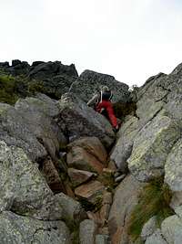
At 10AM, the Hiker Shuttle drops us off and we're heading up Mt. Madison. Despite complete lack of continuity between printed maps from the GPS device software, and signs we read along the way (this problem is commoon to other areas we well) all goes nicely and we relax our top our first president of the trip. It's a tough climb, and more boulderous than one would prefer, telling of what's to come hiking in the northeast. But the views are clear and the sky is blue, with scattered clouds.
We take the short-ish decent down to Madison hut where we fill up on water and relax a moment. Mt. Adams is next, which starts to beat us up a little. Raluca not liking the ascents, whereas the descent starts to really hurt the knees of me and ali.
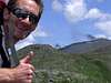
![Topping out on Mt. Adams]() Mt. Adams
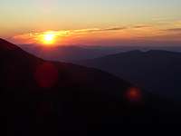
Mt. Adams Since we want to do an early alpine start Sunday, we decide to relax a little and eat dinner early and get some sleep. The sun is mostly blocked by Jefferson, but nevertheless lights up the mountains in color.
Sunday, July 22
Tudor wakes up at 3am, apparently does little more than yell for about an hour as is his nature, then comes to our tent to wake us. We all pack up, snack a little for breakfast, and hit the road by 5AM using headlamps only for the very beginning. A beautiful sunrise soon lights the way.
Tudor heads up and over Jefferson, whereas the rest of us decide, with all the elevation change to come, to bypass this peak and give our legs some break. We meet up on the otherside and continue on. There's no point in skipping Clay because it barely descends at all before you start heading up to Mt. Washington.
![Tudor descending Mt. Jefferson]() Mt. Jefferson
Mt. Jefferson
The many appalling features of Mt. Washington are apparent well before you hit it's actual slopes. Coming south from Madison, Adams and Jefferson, you can see the thick road slashed into the side. As soon as people wake up and start handing over money, you begin to hear the annoying whistle/horn of the train. I'm not sure why they find the need to announce their presence in sound in addition to black smoke but it's done apparently. And of course, there's the number of towers and buildings on the summit, including museum, snack bar, gift shop etc...
![*Industrial Park* on Mt. Washington]() *&$^#(!
*&$^#(!
Raluca, having conquered the tougher half of the traverse, decides to call it quits on Washington and head down via hiker shuttles. After studying the map, Ali and I decide it shouldn't be as bad as the first half (true) and to continue on. Since we made relatively good time to Washington, we figured even though there was lots of down climbing ahead (that was the toughest on the knees), we'd do fine for time.
![Tracks on Washington]() Raluca's way down
Raluca's way down
The weather is still exceptional and we climb down the boulders of Mt. Washington the 1.6 miles to Lake of the Clouds. The knees don't like boulders and they like Tudor even less when he lying says it's an hour later than it was, and that of the two routes on the sign, ours was the 10.5 mile one. Haha tudor very funny. He laughs at me and Ali and says 6.5 miles to go until Crawford notch. Not too bad, especially considering there's some nice level-ish parts coming up.
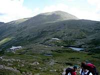
First though, we head up Mt. Monroe, which has cool views of Lake of the Clouds and Mt. Washington as you ascend it.
A little bump on the way down from Monroe is Franklin (~5000 ft). Then there's more or less steady subtle decline to Eisenhower. I vote for going around Eisenhower because I dread any downclimbing at this point, but Ali wants to go up so we do.
We find Tudor "hanging out" with some cool kids at the top, who he has nothing but nice things to say about, asides from "I'll beat my child if she turns out like these kids." We emphatically swallow down essentially the major remains of our food and have some liquids as well. I don't remember needing quite so much food and drink in a trip in a while. That's a good sign that we were doing some tough work.
![Finishing southern end of Presidential Range]() Southern End...
Southern End...
Tudor begins the descent of Eisenhower with Ali and me, but as we're slowing him down, he then takes off at a quicker pace, as he's been doig much of the trip. We say go ahead as it's easy enough to meet at the bottom. Tudor touches the top of Pierce but Ali and I are hurting pretty good and decide to just start the 3 miles downhill. We make really good time at points, but the trail is more of a creek at various points and that slows you down. Wasn't as steep as I was expecting though which is nice. (Didn't have to use our hands at all.)
We all meet up at the bottom and head to Lincoln for our post-hike meal at the Common Man (HIGHLY recommend for the after-meal). Perfect cokes and hearty meals and mudpies. Great way to end a great trip. Now if my knees would just accept my apology all will be well...
Comments
No comments posted yet.