Presidential Traverse
This year’s entry of my annual trek with pal, Flanders, takes us back to the great states of New Hampshire and Maine. As you may recall from a couple previous reports (
Summitfest 1 and
Summitfest 2) this is one of my favorite spots and I still say it is THE place to be in autumn. On this trip, we wanted to hit all of the things we didn’t get to do during our first New England trip. Our objectives were to do the
Presidential Traverse and then the
Knife Edge on Katahdin (which an approaching storm in 2002 made us turn back on).
After flying to Providence, driving to the local REI and heading north, Flanders and I spent a comfortable night in Woodstock, NH with friends of his. The next morning we made our way to Crawford Notch and parked in the lot across the road from the AMC hut. It was dry and cool on this September morning but the clouds covering the summits looked like wet times were ahead of us.
Thankfully, after doing this sort of thing for about 10 years now, we’ve stopped putting extra underwear, books, shaving kits, etc in our packs and we’ve gotten it down to being able to get by for several days in a smaller pack under 30 pounds. We set off in good spirits and made our way quickly up to Mitzpah Hut where it started to drizzle. The hut was crowded and we just had a quick bite before tramping off (and up).
From the hut up to the summit of Mt. Pierce, the trail gets rockier and steeper and in our case, wetter and windier as well. By the time we hit the summit (after a couple false ones), we had to don pack covers and rain gear. Views did not appear to be in our future this day either.
![]()
Pierce is pretty low but already the winds were picking up. From Pierce to Eisenhower, it was one of those heads-down, leaning into the wind treks. It’s funny, looking at the pages for these two on SP, with photos taken from sunny days, it is a completely different mountain that what I imagined in my head. All I could see were my feet below me at the time and a few rocks ahead.
![]()
Awesome views at the summit of Eisenhower
We didn’t waste any time at the summit here. One thing we wanted to do this time in New Hampshire was to experience the huts on the peaks. We had arranged to bunk at the Lakes in the Cloud Hut between Monroe and Washington and we trudged on towards it.
The wind was pretty wild now and the rain was stinging my face. We were leaning into the wind to stay upright and somewhere between Eisenhower and Franklin, I reached back and no longer felt my pack cover over my backpack. Flanders was maybe 30 yards behind me and when he caught up, I asked if it was still there and he said no. This thing was cinched tight last time I checked on Pierce and I just imagined it being whipped silently off my pack and disappearing into the gloom to the west. Somewhere far below there is a nice REI backpack cover for someone to find now.
Nothing more to do but keep going. I can understand now why people question whether Franklin should be included in the Traverse because we totally did not notice there was a peak there until we passed it and I spotted the trail back to it. (The weather also had a little something to do with that though.) Flanders went on towards Monroe, not caring about backtracking to tag a summit, and I ran back up the path to Franklin.
After coming back down from Ben’s peak, I could not spot Flanders. Monroe is pretty close and on a clear day I would imagine everything could be seen. I crossed the short saddle and then took a left on the trail up to Monroe. Although it is a short climb up, I was really getting thrown around by the wind now. The trail then ended in a small rockfield and I picked my way up.
The wind was just getting crazy now. I would stop to catch my balance or grab a rock every few seconds. I made my way up to what appeared to be the summit. Then, the weirdest feeling came over me. I could feel myself getting lifted up by the wind. I immediately dropped to the ground and grabbed a boulder. I was maybe 30 feet from the summit and was wondering how bad it would be once I crested this ridge. I crawled those last 30 feet wondering if I should have just turned tail and headed down. The strongest wind I had ever been in was on Hood and that had been measured at 70 mph. This was easily worse, maybe somewhere around 90, maybe 100 mph? All I knew was that it was scary wind.
![]()
I eased myself over the top and the wind was not that bad on the other side. Whew! But, then I also came to the realization that this was NOT the summit, only a false one. I followed the path to the north again and sometimes could maybe make out a dark rise ahead. At least the wind did not seem that bad here but there was no sign of Flanders. I looked over the west edge, nothing below. It was useless to yell here so I just checked everything out. Nothing. Had he been flung over the edge?
I decided to continue on. Maybe he made a beeline for the hut, maybe he decided to not do the loop and tag Monroe due to the winds. Either way, he was not here. I headed into the gloom to the north and soon did the climb to the real summit. There was a nice cleft between rocks there and I got a quick bite to eat out of the wind.
There was an ominous sound coming from the north though. A low growl that came and went. Sometimes it was really loud but then trailed off but it always came back. The only thing I could think of was that it was the wind howling over the ridge.
I hiked down from the summit towards the sound. My imagination was going wild. It sounded like some wind dragon that was going to whip around the corner and eat me like that evil thing that came out of the Arc of the Covenant in Raiders of the Lost Ark. As I descended though, it was nowhere to be seen. What the hell was this thing?
Then, as I got down to somewhat flat ground I could see it. It was a device on top of the hut used to measure wind speed! Gusts would send it flying around in a blur and that was when the growl came. At last, I was at the hut, but still no Flanders.
I got in the door and could see everyone was already eating. One of the hut workers came over to me, told me where my bunk was and that they would get a plate for me. I then saw Flanders at one of the tables eating. He had gotten there, noticed dinner was being served and made sure they knew I was coming and needed food (they were about to close the kitchen). Sweet! Hot food!
I dropped my dripping pack near the bunk and went out to eat. There was some soup that warmed me up and the hot meal did wonders for my outlook. The bunkhouse is nice but thank God they sell the earplugs at the counter there because we had the snorers in our room. Didn’t get much sleep that night and I think Flanders got less.
Morning came early and breakfast was oatmeal and I forget what else. There was some skit put on by the hut workers about folding your blankets and packing out your garbage. I still wanted to tag Washington but while the wind was not as bad this morning, the rain was heavier. Flanders decided to forego Washington as we had both summitted it via Tuckerman’s years before. We decided to meet up where the Gulfside Trail and the Westside Trail meet and I set out about 45 minutes before he did.
![]()
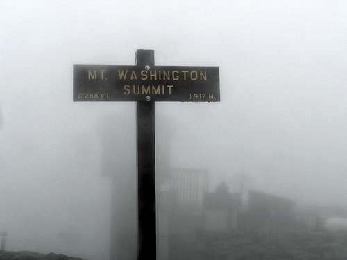
The hike up to Washington was quick but wet and cold. The usual zoo was at top. Tons of Japanese tourists smoking clogged the way into the building. I did take a photo of the summit sign, much different than years before when we had great weather. Tried to dry off as much as I could, got a quick power bar in me and then headed down. Shortly after I crossed over the cog railway a train was coming up it and I got caught in a black cloud of its smoke. Blech! I worked my way down and heard a familiar voice yelling below me. It was Flanders and he had bunkered down behind a rock near the junction of the trails but he had been there a while and was cold.
We did not waste time hanging around but hit the trail to Clay. Again, it was pretty viewless and I just remember some mounds, the next one being higher than the first. We did find the summit and just kept going. The trail drops down and was wet and slippery. We carefully scrambled down to the saddle between it and Jefferson.
On through the clouds and rain we went, more of a moonscape than trail. We found the loop up to Jefferson and hiked up that pretty quickly. After tagging the summit, I had to pee so Flanders stayed back at the base of the summit mound. I did my business and heard him call my name. I yelled back “What?” but didn’t hear anything. When I finished, I turned around and saw nothing but fog. I yelled for him again but could hear my words just fall in the mist like I was talking to a wall.
I walked around calling out but nothing. The summit is a junction of 4 trails (and one of those also splits into another one shortly below the summit on the east side. I double-checked the map to make sure I had the right one in the pea soup and headed down, thinking he must have taken off before me.
Half an hour later, still descending, I was still alone. My voice was getting hoarse from yelling so I decided to head down to the next junction of trails on our way to Adams and the Madison Hut. I got down and waited. And waited. And waited for about 45 minutes. Nothing. Thinking he must have gone down the wrong trail (because I typically hike a little faster than him and would have caught up to him), I waited until I thought he would have come down and gotten to that point.
Now I had a decision to make. Had he actually gone faster than me on the right trail, or slower than normal on the wrong trail? I had no way of knowing and now I was getting pretty chilled and wet. The only thing I knew for sure was that our main objective of the day was to get to Madison Hut where we were going to camp in the nearest tent area.
I decided the best thing to do would be to head to Mt. Adams as planned and then do a loop down the back side to Madison Hut and if I had not found Flanders by then, I could circle back down this trail to Jefferson again. I booked my way to Adams and up the side loop to its summit. Again, it was cold, very windy and pelting me with rain. The summit sign looked wrong to me in the near white-out pointing to a trail that looked like it went the wrong way. Double-checking my map did not help but I decided to trust the sign and headed down what I thought was southeast. It was the right thing to do, trusting the sign, as I did get down to the Air Line Trail (it was actually on a mostly northern heading, I was just all turned around in the unfamiliar viewless gloom) back to the Gulfside Trail which led to the hut.
![]()
Summit marker on Adams
I hurried up and found the hut but still, no Flanders. I was soaked and hadn’t eaten much in my hurry so I warmed up and had some food. I asked the rangers/hut workers if they had seen my friend and they had not. There was something on the radio though about other rangers finding another party that was lost in the weather so now I was kind of getting worried. There were two hours until sundown and I told the ranger girls I would head out for one hour and then come back and that if he showed up to tell him to stay there until I got back.
I put on my jacket and headed out into the rain back along the Gulfside Trail. I got about 10 minutes back up the trail when I ran into 3 people, one of them Flanders. He had joined up with two other hikers who had lost the rest of their party too. We headed back in the hut and I got the scoop on what happened nearly 5 hours earlier.
When I had yelled out “What?” to Flanders, the wind had carried the sound around and to Flanders, it sounded like I was calling out behind him, down the northwest side of the mountain and the Castle Trail. He headed down, thinking I had somehow gotten around him. Ten or fifteen minutes down the trail, he realized something was wrong and then he headed back up to the summit again. He looked for me and went down the correct Jefferson Loop Trail but not finding me again, ascended back up the summit. Finally, he did the same thing I did and headed for the one sure objective we had that day, the Madison Hut. He had not gone up Adams but somewhere along the line, hooked up with the other two climbers and hiked with them until he found me, shortly before the hut.
So, soaked and tired, we decided not to camp but to stay at the hut and luckily, there was still room. Dinner was great and afterwards, four AT thru-hikers got up in front of everyone and talked about their adventures coming up from the south. I crashed shortly afterwards, listening to the rain hit the window by my face.
The morning was weird. For one thing, the sky was mostly blue and there was no rain sound!?!? I could see a rocky mountain next to me instead of fog whipping around. Breakfast was again the same oatmeal deal and again, we got a skit about folding blankets. The last peak on our agenda was Madison which would be a quick up and back hike to the summit from the hut so we could leave our packs and go light.
The trail starts right from the side of the hut and scrambles up boulders most of the way. It did not take long and we were in the warm sunshine. In no time we were on the summit ridge following more giant cairns to the top. I think we took a little extra time at this summit to enjoy a few things we had not had on this trip: sunshine and views.
![]()
But, we also knew there was a shuttle we had to catch to get back to the car on the south end of the Presidentials. We went back down to the hut, retrieved our backpacks and headed down. I was traveling a bit faster so I went on ahead to make sure to catch the bus but really didn’t need to. We were there in plenty of time and laid our socks in the sun on some boulders there while waiting as they were still cold and wet from the soaking over the previous days. We did run into one of the AT thru-hikers at the shuttle stop and chatted with him. He ended up wanting to hitch-hike and it took him all of about 3 minutes before he caught a ride to where he was going. We waited a bit and then were the only ones on the shuttle back to our car.
The Knife Edge on Katahdin
The rest of that day was a drive day to Katahdin. We stayed in a motel somewhere in Maine so we could dry out clothes, our tent we had carried with us, etc. I gorged on Cheetohs but threw the large bag of cheesy goodness away about halfway through it as I got sick of having so much of it. The next morning, after raiding the continental breakfast for all it was worth at the motel, we headed up to Katahdin. I instantly loved this mountain when I first visited it 4 years prior. We had wanted to do the Knife Edge but once on the summit, we had to bail due to an oncoming storm. I always wanted to come back and do that route and had made the required Baxter reservations months before. Now it was time!
Well, almost, even though I am the maintainer of the Katahdin page, I ended up navigating us through town and into the country, missing the correct turnoff to the park. Oh well, something new to add to the Getting There section, I guess.
Once we were there, we changed into hiking clothes and headed to Chimney Pond where we had reservations in a lean-to. The hike in was quick and uneventful, save for Flanders coming to the realization he had forgotten the lighter for the stove. We were almost to the pond so I told him we’d find someone to borrow one from there. Once we got there, he found that he actually did pack it so we were good for a nice rehydrated dinner beneath the stars.
Clouds had been coming in and out since we got there and we wondered if we would have views. The forecast indicated we were in a small window of nice weather for the next day or two and we were hoping to avoid any of the crap we had just hiked through.
In the morning, we got a decent start across the Chimney Pond area to the start of the Dudley Trail. Soon we were scrambling up the steep forest by boulder and tree root. The trail goes pretty much just up over large boulders, under trees, around trees, over slabs, etc. After maybe half an hour to an hour, you break through into just large boulders. Fun scrambling and easy to follow the route as there are paint streaks everywhere. The clouds were still hanging on the tops of the ridges near the summit. No sign of Baxter Peak yet.
![]()
After a couple hours, we came to Index Rock, a large angular slab of granite pointing skyward. Quite the waypoint. It was at about this point, we noticed the skies were clearing to our right and the summit was OUT! Sweet! We grabbed a snack and the continued the scramble upwards.
The trail gradually tapers off into more of a trail amid small bushes and smaller boulders. Then, the Pamola Peak sign comes into view and we were there, on the start of the Knife Edge. The wind was a bit more at this point and there were a lot more people (they came up Abol Trail). We found someone to take a snapshot of us, the annual Brian and Brian photo.
Then it was time to face the crux. I think Flanders had some trepidation about this section but we went over, looked down and I could see it was going to be cake. There are one or two spots of some exposure on the Class 3 scramble down to the Notch. It’s all of about 40 feet but I can also see where those who don’t do this much could waver. Actually, once I was down I could see a walking trail someone had worked into the ridge on the right but, not knowing anything about that, I didn’t say anything.
![]()
The Notch
A guy and his mom scrambled down ahead of Flanders and then he worked his way down without problem. The other side of the Notch is the same thing in reverse. A Class 3 scramble up about 40 feet. There is also one exposed part on this that you don’t want to lose your grip on but it’s easy.
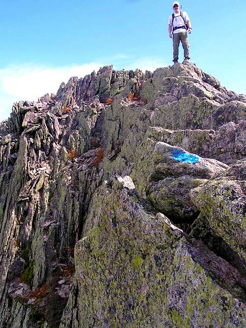
Now we could see the whole of the Knife Edge ahead of us. And it did not look bad, just fun. We tried to stay on the Edge as much as possible. I am not sure why this is considered so dangerous, the outside edge is a pretty gentle slope. There are parts on the inside you would not want to fall on but the worse is easily avoided, there are many options to go around problems and barring weather and wind, I don’t think anyone would have much trouble with this route.
![]()
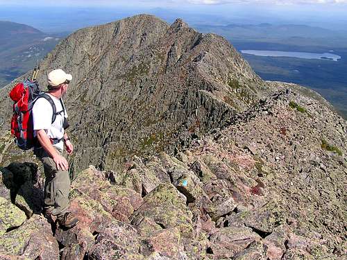
But it is just a fun walk and scramble. Great views, you know you are working at it, and it gradually steepens in front of you. As it steepens though, the “knife” edge becomes a soft ridge. For a good hour or so we were on the Edge though. As you near South Peak, the rock turns worse and loose and you work your way up to the top. From there, it is an easy ridge walk over to Baxter Peak and the summit.
![]()
We ate some at the summit and then headed down to the saddle and the Saddle Trail back. It was a most enjoyable return to Katahdin and again, I hope to go back someday to maybe tackle some of the technical routes up the rock face below Baxter Peak.
When we got back to the lean-to and found our stuff still there (happy!), it was then an easy hike back to the car and Roaring Brook campground where we stayed that night and Flanders pulled out the back of Cheetohs he had rescued from certain destruction from the motel room. Good man! Bravo!
We had to make a decision that night whether to stay in Baxter and hit the other peaks around or make our way down through Maine seeing what we could find. We decided on the latter as the rest of the peaks looked pretty much the same and, after doing Katahdin, you really can’t get too worked up about a small mound on its flank.
We spent the next day as an off day driving south in the fog and clouds (Thank you Katahdin for holding off the weather while we climbed!) and from a book Flanders has, we picked out Mt. Megunticook as an objective. Looked like it had some ocean views and a nice trail. We stayed that afternoon in the state park at its base and walked down to the ocean on the trails there. We made a feeble attempt at a fire that night but, not wanting to spend money for firewood from the camp hosts, we did not have much luck with the wet and freshly cut wood we found.
In the morning we headed back to a trailhead on the other side of the peak from where we camped and I am glad we did as that trail turned out to be a great way to cap off Maine. Megunticook is a really popular little peak on the coast of mid Maine with some big payoffs. Shortly after you start up, you reach a cliff overlooking a lake with some huge old plantation-like homes on it. After that, we jumped into the sun on a ridge and followed some open rocky paths for a ways before back into the woods and up to the summit.
Although the summit has no views, it’s a short distance to probably some of the best views in Maine at the ocean viewpoint. These are some cliffs facing south and east overlooking, obviously, the ocean but also Mount Battie and the town of Camden which was quite picturesque with a small harbor filled with sailboats and the prerequisite New England big ass church and steeple. We hung out in the sun for a while and then went back down. This was a cool little peak with enough different trails to keep you from getting bored while getting your workout in.
![]()
After Megunticook, we headed back to Massachusetts to Flanders home and the next day ran up his workout route in the Blue Hills of Massachusetts. Nice views of Boston from there and a fun boulder to play on. It was close enough we were back at his house in time for opening day of football too! Another successful New England Summitfest for us and although the weather did not cooperate on the first half of it, we ticked off all the peaks we aimed for.
Now, on to planning next year’s trip….


Comments
Post a Comment