
-
 20990 Hits
-
 82.48% Score
-
 15 Votes
|
|
Route |
|---|---|
|
|
46.16380°N / 10.89280°E |
|
|
Via Ferrata |
|
|
Half a day |
|
|
medium via ferrata |
|
|
Characteristcs
this is I think the best and most panoramic hike of the whole group not the hardest !In fine weather days in july and august here you can find a lot of people and have (for it) some troubles on the sentiero Benini De Stanchina and sentiero Figari where the ledge in some points is very narrow.
The Bocchette Centrali is made of 4 different paths :
starting point : Rif. Pedrotti - mt 2491
ending point : Rif. Alimonta - mt 2580
top point : eastern edge of Torre di Brenta - mt 2770
time requested : 3h 30'
signs : 318 - 305
difficulty : low-medium
hardness : low
exposure : high
snow on the track : Bocchetta del Campanil Basso
 |  |  |  |
Approach
3 different starting-ending points :Rifugio Pedrotti
you can get it starting
on foot : path 317 - to Rif. Casinei, then path 318 : 2 h walk from Vallesinella you get the Rif.Brentei and, in 1 more hour, along the path to the Bocca di Brenta you can get the Rif.Pedrotti
using a two person standup lift to Rifugio La Montanara (1525m)
walking along the Val delle Seghe to Rifugio Croz dell'Altissimo, then follow for Rifugio Selvata (1663m) and with a confortable walk (a little steep in the final part, to Rif. Pedrotti (4h 30' from La Montanara)
Rifugio Alimonta
you can get it starting from Madonna di Campiglio (1515 m)
by car or taxi-service to Rifugio Valsinella (1513 m).
on foot : path 317 - to Rif. Casinei, path 318, 2 h walk to Brentei
then 1 more hour to reach the Alimonta Hut
Rifugio Brentei
the best for this hike - you can choose where to start from and amuse the trip all round the Sfulmini chain and, if weather is fine, use a very light backpack leaving in the refuge all that you don't need :)))
Route Description
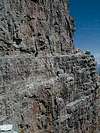
from Rifugio Pedrotti follow the path to Bocca di Brenta (between Brenta Bassa and Brenta Alta).Go down about half-hundred metres (red marks on stones on the right) till you see a metal stair on the right (Brenta Alta wall) that leads to the big ledge where sentiero Gottstein runs.
Few meters to the right you can find a fantastic fountain coming down directly out of the rock !
Follow the easy (exposed) ledge till it turns to the N side of Brenta Alta (wonderful view of Campanile Basso SW face),
 ..
.. 
Some short stair and an easy scramble leads you to the Bocchetta del Campanile Basso where the metal rope can be hidden by the snow (careful !)
After crossing the Bocchetta you get the east side of the Sfulmini chain.
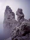
Some scramble to get the Sentinella (fantastic Belvedere on the East face of Campanile Basso and North-East face of Brenta Alta.
Then, along a very long system of ledges (some very very exposed) you pass under the Sfulmini and the southern side of Torre di Brenta arriving about a hundred meters above the Bocca degli Armi.
A system of metallic stairs leads you down to the bocchetta and, along the Vedretta degli Armi (keep the right side) you arrive to the Rifugio Alimonta
fot other pics give a glance to this section of Dolomiti di Brenta page
 |  |
Essential Gear
Usually hikers use a complete set for via ferrata, but I think it can be very faster using a single rope for hiking (8mm).Very experienced hikers and climbers can do it without gear.
Only one danger point in case of snow or ice : the west side of the Bocchetta del Campanil Basso .