
-
 12710 Hits
-
 79.78% Score
-
 11 Votes
|
|
Mountain/Rock |
|---|---|
|
|
46.74220°N / 12.81140°E |
|
|
8526 ft / 2599 m |
|
|
Overview
Geographical Classification: Eastern Alps > Gailtal Alps > Lienz Dolomites > Böses Weibele (Rosenköpfl)
Böses Weibele is a twin peaked mountain in the east of the Lienz Dolomites (themselves part of the Gailtal Alps) in southern Austria. It is located to the south of the city of Lienz and so is very close to the other SP summit across the river Drau – Böses Weibl. To make matters even more complicated there is a third mountain of the name in the Deferegger Mountains (also north of Lienz) which has a second name: strickkofl. Except for the names and, three mountains so close to each other couldn’t be more different. Both the Böses Weibls to the north are part of Hohe Tauern, a range mostly composed of Gneis Rock. The star of the page you are reading, Böses Weibele, is a typical dolomite summit composed of limestone with vertical walls and large scree fields at its base. Both mountains have second names, probably because otherwise the inhabitants of Lienz themselves would have been confused.
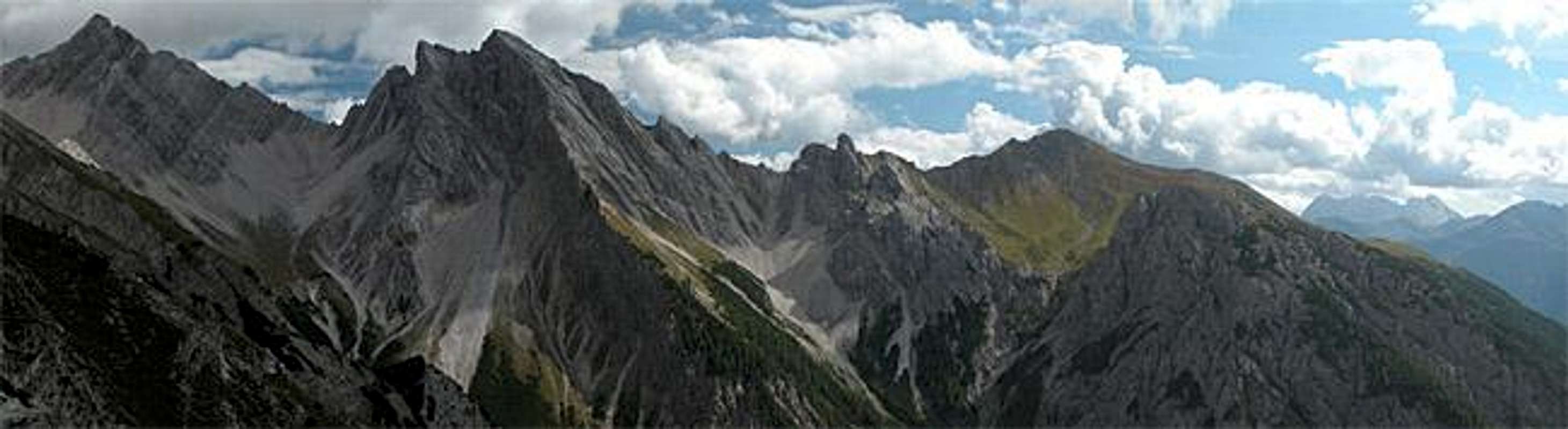
As said above, Böses Weibele is a twin summit. Both summits are only 10m apart vertically and some 100m apart laterally. It is a good showcase for the geology of the region. The Drau and Gail Valleys to the north and south of the Lienz Dolomites resp. are located directly on the Peradriatic Fault, the division between the European and African tectonic plates. Thus they were the arena in which the building of the Alps was most dramatic. The area was covered by seas in the Orovicicum and Trias ages. Thus much of the rock is sedimentary in nature. You will be able to see the various layers beautifully on any mountain of the region. In between the two “sea ages” a first mountain building set in, when the African plate started pushing into the European one. Erosion did away with much of the mountains but after the second sea – the Thethys Sea, which also created the Dolomites – had left its sediments, the massive build-up of the Alps began. Due to the location of the fault right in this region the results are quite chaotic. Look at the large and signature pictures and you’ll see that the layering of Grubenspitze to the right differs significantly from the one of Böses Weibele in the centre. And if you look close you can see the “circular layering” near the top of Böses Weibele (also at the right base) which was created by collapses during the Alps build-up. In fact these “faults” are the explanation for the second name – Rosenköpfl (= Rose Head) since you can see them on all sides of the mountain.
And speaking of names: we have already discussed this topic for the other Böses Weibl. The name means “Evil Woman” or “Witch” and is typical for the mysticism of the middle ages when these mountains seemed inaccessible and claimed many a life. On my first day in the Lienz Dolomites I got another notion why this particular mountain had been called that way. A permanent nasty, foggy gumbo was boiling in the cauldron of the Wildensenderbach Valley to the west of the mountain. The summit itself was invisible but the flanks appeared now and then out of this mess. We had planned to climb this mountain but turned back because of the weather. A very unwise decision since two hours after we had started to descend the weather cleared and all the summits – even Böses Weibele became visible.
Climbing the mountain is far from easy. Follow one of the routes to Riebenkofel (will be put up soon) and from there follow the ridge to the base of Böses Weibele. From there follow the southern ridge to the lower south-western summit (2589m), always keeping on the western side of the ridge. The traverse to the main north-eastern summit (2599m) is lofty. Though the trails in no places exceed UIAA I grade they are very exposed in places and you have to ascent on steep gravel ridges. Nothing, you would like to do in foggy conditions.
 |  |  |  |
Getting There
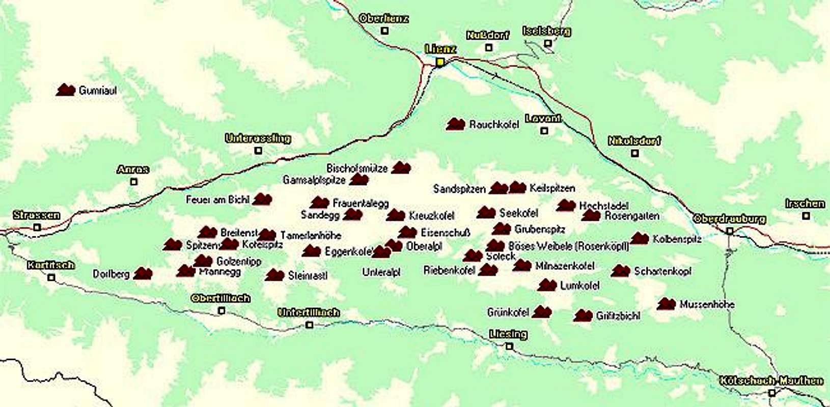
The best starting points for an ascent of Böses Weibele are the hamlets of Assing (north of Liesing) and Tuffbad (north of St. Lorenzen). Both trailheads are located to the south of the Lienz Dolomites in the Lesachtal Valley. The valley is rather remote but getting there is far from complicated (though lengthy).
From the West (Brenner Motorway A22)
Leave the Brenner Motorway near Brixen / Bressanone and follow SS49 to the east through Pustertal / Val Pusteria. To the east of Innichen / San Candido you cross the Austro-Italian border and follow the road (now B100) to Tassenbach. Turn right (south-east) here onto B111, which you follow to St. Lorenzen or Liesing, depending on your preferred trailhead. In either of the two villages turn left. You’ll reach Tuffbad from St. Lorenzen by an asphalt forest road through the Wildensenderbach Valley. Assing can be reached by another narrow road from Liesing.
From the North
There are two possible roads:
- From Kitzbühel over B108 through the Felbertauern Tunnel to Lienz, then southeast to Oberdrauburg and Kötschach-Mauthen (B110), where you turn on to B111 west into Lesachtal.
- From Salzburg along motorway A10 to Spittal. Turn west on B100 to Oberdrauburg, there south to Kötschach-Mauthen were you turn east on B111.
From the South (Udine)
Take Motorway A23 to the exit Camia Tolmezzo. Follow SS52 north to Tolmezzo where you turn onto SS52 bis. This leads to Plöckenpass, where it crosses the Austro-Italian border. In Austria the road turns into B100 and at Kötschach-Mauthen you have to turn east on B111 into Lesachtal Valley.
 |  |  |  |
Red Tape

No red tape to be found here. In some places in the north of the Lienz Dolomites you are asked to keep your dogs on leash because of grazing sheep. But apart from this regulation I didn’t find anything else.
When To Climb
The season runs from late June through September. Sometimes even October can turn out some warm days and these are the best days for hiking anywhere in the Alps. Very clear and crisp with great far reaching views. The ascents to Riebenkofel or Lumkofel to the south of Böses Weibele are possible with skis but Böses Weibele is out of the question for winter. You won’t find much ski action anyway (except for cross country), since there is only one small ski lift in the whole Lesachtal Valley!
 |  |  |  |
Accommodation
In most of the villages of the area there is a small campground, which in most cases is associated with an inn or hotel. If you are looking for hotel rooms or apartments follow one of the links below
- Lesachtal official site
- Lienz City official site
- Kötschach/Mauthen official site
- Lesachtal lodging (tiscover.at)
- Kötschach Mauthen lodging (tiscover.at)
- Lienz Dolomites lodging (tiscover.at)
- Hochpustertal lodging (tiscover.at)
 |  |
Weather Conditions
In general the weather in south-eastern Austria is much better than in the northern and western parts of the country. Europe mostly is covered by western winds and the clouds from the Atlantic have to climb over the Alpine Main Ridge before they reach Osttirol or Kärnten. So much of the humidity is left somewhere else… For up to date weather information (city of Lienz) follow the link below.
For Webcams try one of the below:
 |  |  |  |
Mountain Huts and Refuges
There is no hut in the direct vicinity of Böses Weibele. The nearest is Hochstadelhaus, some three hours away from the base of the mountain. The table shows all mountain huts in the Lienz Dolomites.
| Rifugio / Hut | Height | Open | Tel. |
| Hochstadelhaus | 1780m | mid June - end Sept. | +43 4710 2778 |
| Karlsbader Hütte | 2261m | mid June - end Sept. | +43 4876 8323 / +43 664 9759998 |
| Kerschbaumer Sutzhütte | 1902m | mid June - end Sept. | +43 4852 63374 |
| Lienzer Dolomiten Hütte | 1616m | all year (except mid Nov - mid Dec.) | +43 664 2253782 |
Maps 'n' Books
Maps
I have been using a map by Kompass Verlag, which is very good for the hiking trails though it does not show ALL the relevant summits of the area.
- Lienzer Dolomiten / Lesachtal
1:50000
Kompass Map WK47
Kompass Verlag
ISBN: 3-85491-053-3
Books
You’ll probably not be able to find anything on the Lienz Dolomites in a language other than German. The books I used are (both describe the ascents of Riebenkofel but the remaining 300m of elevation to Böses Weibele are not covered):
- Hiking and Trecking
Osttirol Süd
W. Mair
Rother Verlag
ISBN: 3-7633-4132-3
Good descriptions with maps covering: Defregger Berge, Villgrater Berge, Carnic Alps, Lienz Dolomites
- Gailtal – Lesachtal – Karnischer Höhenweg
Kompass Wanderbuch 982
Kompass Verlag
ISBN: 3-85491-500-4
Good Descriptions with maps and elevation profiles covering: Carnic Alps, Southern Lienz Dolomites, Gailtal Alps