
|
|
Mountain/Rock |
|---|---|
|
|
37.89703°N / 107.62392°W |
|
|
13286 ft / 4050 m |
|
|
Overview

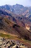
West face, Bonita is the peak with a flat top on the left

North face of Bonita

SW face of Bonita
The summit of Bonita
Like many other ghost towns in the San Juan Mountains of southwest Colorado, the ghost town of Gladstone did have its fair share of glory days. The town was established in 1878 and was named after the Prime Minister of Great Britain. It thrived on mineral riches that were brought into it from the multitude of mines that surrounded it. The most profitable of these mines were the Gold king and Upper Gold King Mines that were located on the slopes of Bonita Peak.
Gladstone sits at the bottom of the valley of Cement Creek at an elevation of 10617 ft. To the east of it, a string of 13er peaks make a formidable wall. North to south, these peaks include: Bonita Peak 13286 ft, Emery Peak 13310 ft, Peak 13330 ft, Peak 13229 ft, Velocity Peak 13325 ft and Storm Peak 13487 ft. To the north and west, Gladstone is bound by the slopes of Red Mountain #1, 12592 ft and Red Mountain #3, 12890 ft (The Red Mountains are not visible from Gladstone).
A hike to the summit of Bonita Peak takes you through Minnehaha Basin, a high valley above timberline that sits at an elevation of 11700 to 11900 ft below the summit of Emery Peak. The boggy floor of the basin houses a beautiful wetland. A craggy reddish/brown mountain rises very abruptly above the basin to an elevation of 12601 ft creating a very impressive site.
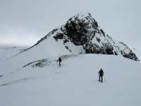
Compared to the jagged summits of Storm and Velocity Peaks, Bonita looks very benign. From Gladstone, it appears as a steep slope that leads to a long and narrow summit. Close up, the upper slopes prove to be grassy but very steep. The last 200 ft is made of steep crumbly rock that can be climbed using hands and feet without technical expertise. The very top is a dizzying narrow ledge.
From the summit, you get a unique view of the Red Mountains to the west. Beyond these, you can identify the giant pyramid of Mt. Sneffels (14150 ft) to the northwest. A continuous chain of 13er peaks stretches south of sneffels to Vermilion Peak (13894 ft) to the southwest. To the east, the almost vertical slopes of Bonita drop into Eureka Valley 1000-1500 ft below. This makes you feel like you are flying over the valley. The roar of an occasional 4 wheel drive vehicle struggling up the Eureka Gulch Road can be heard from the top. With keen eyes, you can identify the former site of Lake Emma in upper Eureka Valley. A two mile long tunnel used to bore through the mountain connecting Mogul Mine to the west of Bonita to Sunnyside Mine to the east near Lake Emma. On Sunday June 4, 1978, the roof of a tunnel that was being excavated under Lake Emma collapsed causing the lake to drain into the tunnel creating a massive flood that exited the west end of the tunnel above Gladstone. Fortunately, no one was killed.
Bonita Peak is rarely climbed. You can have the whole mountain to yourself.
 |  |  |  |  |
Getting There & Route via Minnehaha Basin
Take Route 550 to Silverton (elevation 9318 ft), drive to the east end of town and turn left on Route 110 heading north (If you turn right on 110, you will end up in Howardsville). Route 110 is a well-graded dirt road that is passable by any car. Follow it 8 miles along the banks of Cement Creek to the ghost town of Gladstone (10617 ft). Go to the end of the 2 wheel drive road near a mill that seems to be still operational. This is your trailhead.Trailhead Elevation: 10617 ft
One way distance per my GPS: 2.9 miles (1.9 miles on a moderately rough 4WD road that can be driven to shorten the hike to 1 mile)
Approximate Hiking Time: 3 hours (one way uphill)
Maps: US Geological Survey, Colorado "Handies Peak" grid
At the trailhead, you will find two 4 wheel drive roads: one heading north and one south. The north road is signed as San Juan County Route 53. Hike 53 about 100 ft till you reach Route 51 to the right. Turn right on this road and follow it up a couple of switchbacks through a Pine forest till you reach the junction of a nameless 4 wheel drive road on the left below the Minnehaha Basin (11500 ft). Turn left on this road and follow it up into the left (north) side of Minnehaha Basin where you reach an abandoned mine/mill (11850 ft). At this point, you have come 1.9 miles from Gladstone. You could have driven to here on the road which is classified as moderately rough.
At the mine/mill, the road makes a switchback and goes around a ridge on the north side of Minnehaha Basin to enter a drainage below the summit of Bonita Peak. The road here is much rougher but it is easy to hike. You will find a few abandoned shacks on the ridge. Once below the summit (12300 ft), you should leave the road and head straight up the very steep grassy slopes (the road eventually dead ends at Upper Gold King Mine). I approached the rocky summit of Bonita from the southwest where I was able to climb it without any difficulties.