
|
|
Mountain/Rock |
|---|---|
|
|
47.97900°N / 121.25245°W |
|
|
Snohomish |
|
|
5727 ft / 1746 m |
|
|
Overview
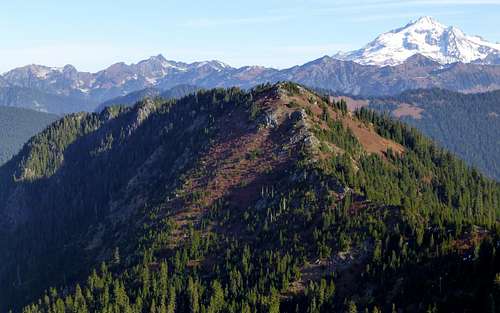
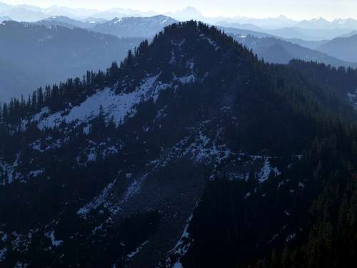
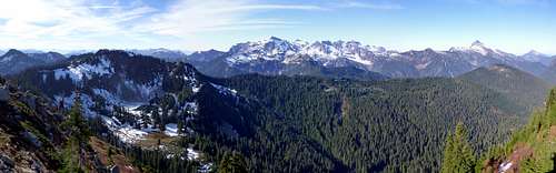
North Bowser Butte and Glacier Peak from South Bowser Butte
North and South Bowser Buttes (unofficial names) are 5727' and 5721' (respectively) peaks located four miles east of the Monte Cristo subrange, and one mile north of Bald Eagle Mountain. While USGS cartographers did not see fit to provide names for either peak, they are the highest points on the ridge that is bound on the north by Sloan Creek, and on the south by the North Fork Skykomish River. Additionally, North Bowser Butte is the most prominent point on the ridge (947'), and provides the best views of all the high points. While there are a number of ways these peaks can be approached, most parties will elect to approach via Curry Gap.
Getting There
Curry Gap can be approached from the north via the Bald Eagle Trail (FS #650), or from the south via the Quartz Creek Trail (FS #1050).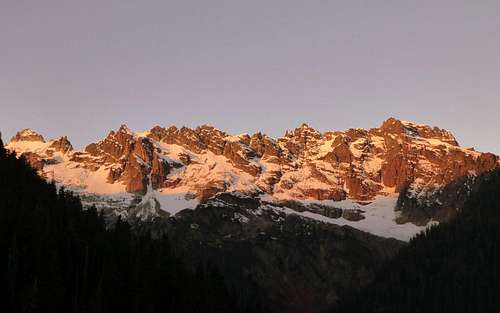
Early morning sunrise on the Monte Cristo peaks. Taken from the Bald Eagle trail below Curry Gap.
For those approaching from Marysville and points north (recommended):
(Copied from USFS) Access 1: From the Verlot Public Service Center (11 miles east of Granite Falls, WA), drive east along Mt. Loop Highway 27 miles and turn right onto Sloan Creek Road (Forest Service road 49). Follow it for 9.5 miles, passing Sloan Creek Campground at 6.5 miles to the trailhead a half mile past the stock unloading ramp and toilet. Access 2: From the Darrington Ranger District office, take Mt. Loop Highway 20 along the west side of the Sauk River. Drive 16.3 miles to the Sloan Creek Road (Forest Service road 49) and turn left.
Follow the Bald Eagle Trail south for about 4.2 miles to Curry Gap. The first 2.5 miles will be old road bed that has been converted to trail.
For those approaching from Everett and points south (recommended):
(Copied from USFS) Drive US Highway 2 to just west of milepost 50 (located between the town of Skykomish and the Skykomish Ranger Station). Turn north onto Beckler Road #65, toward Beckler River Campground. From US Highway 2 on Forest Service Road #65, drive 15 miles and turn right on Forest Service Road #63. Continue 4.2 miles to the trailhead, on the north side of the parking lot.
Follow the Quartz Creek Trail north for about 4.0 miles to Curry Gap.
Route
From Curry Gap, continue southeast on the Bald Eagle Trail, which will begin a steep climb towards the top of the ridge. At a point approximately 1.2 miles from Curry Gap, you will arrive at a saddle in the ridge, which is located northwest of South Bowser Butte's summit. If it is your intention to only climb North Bowser Butte, this would probably be the best place to start your off trail scramble. Make a near level traverse to the east towards the Bowser Lake Basin - you can expect a few moves of class 3 scrambling shortly after leaving the saddle. In no case should you descend below 5000' before reaching the basin, as you will encounter cliffs if you do. Upon reaching Bowser Lake Basin, simply head northeast towards North Bowser Butte's summit (easy scrambling, mostly class 2).If it is your intention to also scramble South Bowser Butte and/or Bald Eagle Mountain, continue on the Bald Eagle Trail to the next point the trail reaches the ridge crest (about 2.0 miles from Curry Gap, south of South Bowser Butte's summit). From here, scramble the ridge crest 0.5 miles to South Bowser Butte's summit (mostly class 2).
Bowser buttes from the north side of Bald Eagle Mountain - South Bowser Butte on the left, North Bowser Butte on the right.
Views from South Bowser Butte's summit will be fairly good, but not as good as the north peak. According to the USGS map, this peak is six feet lower than the north peak, which my GPS seemed to confirm (although to my untrained eyes, the north peak appeared lower).
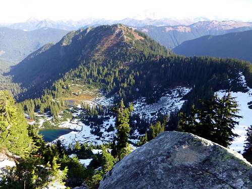
North Bowser Butte and Bowser Lake from South Bowser Butte
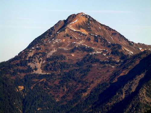
Bald Eagle Mountain from South Bowser Butte
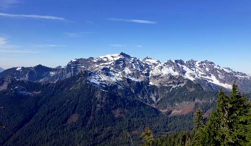
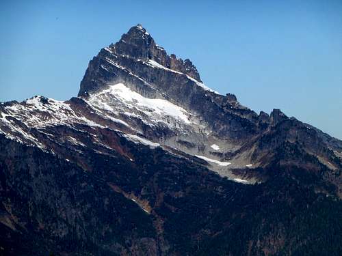
Monte Cristo peaks from South Bowser Butte. Kyes Peak (highest of the Monte Cristo peaks) shows off its impressive east side in the center of this photo.
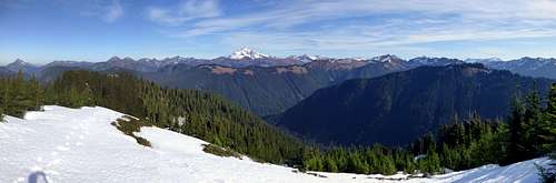
To continue to North Bowser Butte, simply follow the connecting ridge northeast, then north, for 0.8 miles to the summit. The scrambling is surprisingly easy, and the timber is fairly open between the two peaks. The final scramble to the summit will be class 2. Views from the north peak are quite nice, particularly looking west towards Sloan Peak and the Monte Cristo peaks.
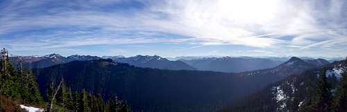
North Bowser Butte pano - northeast through south
North Bowser Butte pano - northwest through east
North Bowser Butte pano - south through northwest
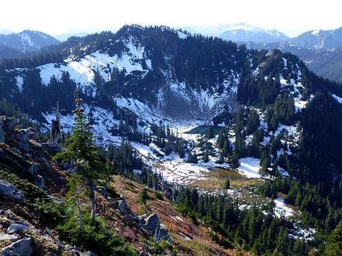
South Bowser Butte and Bowser Lake from North Bowser Butte
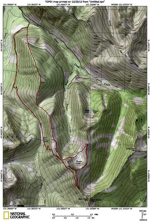
Bowser Buttes and vicinity. Red line shows the track for my hike/scramble (I wanted to summit Point 5003 as well). I approached from the south side of South Bowser Butte (convenient when making a side trip to Bald Eagle Mountain), followed the ridge to North Bowser Butte, then returned to the saddle northwest of South Bowser Butte via Bowser Lake.
Here are links (used with permission) from a 2012 trip that was fairly similar to my own, except that the approach was made from Quartz Creek (great photos):