
-
 18053 Hits
-
 82.48% Score
-
 15 Votes
|
|
Mountain/Rock |
|---|---|
|
|
48.07445°N / 121.25365°W |
|
|
Snohomish |
|
|
Hiking, Mountaineering |
|
|
Spring, Summer, Fall, Winter |
|
|
6975 ft / 2126 m |
|
|
Overview
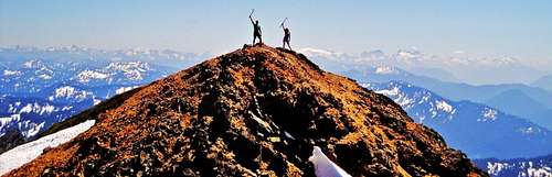
On The Summit, July 2010

Starting Elevation:2100 feet
Summit Elevation: 6975 feet
Total Gain: 4875 feet
Round Trip Distance: 8 miles
Originally named "Ska-hala-bats" by the American natives of the area, the translation means painted. The mountain was renamed Red Mountain by Sam Strom and a prospecting party which has caused some confusion over the years. Painted Mountain is one of the higher summits in the immediate area surrounding Glacier Peak and was probably first climbed in 1897 by members of the U.S. Geological Survey. It was once the location of one of the fire lookouts that used to be frequent in north Cascades. The lookout which was constructed in 1936 was not located on the summit but rather along the southwest ridge in proximity to the Pride Basin overlook. The lookout was short-lived for it was destroyed in 1967.
The Route
Beginning at the North Fork Sauk trail, proceed 50 yards to the beginning of the old trail on the left. The sign reads "Painted Mountain Lookout trail 1 mile". Don't be confused. This doesn't mean one mile to the beginning of the trail. The official trail is only mile long and does not continue beyond. If you are looking at the Green Trails map you will noticed only part of the route is shown. Passing some very large trees, after a quarter of mile there is a nice overview of Pride Basin. At 3100 feet, the reason for the end of the official trail becomes apparent. Novices should not continue beyond this obstacle. Steep rock covered with dirt and moss block the way. Fortunately a series of ledges switch back and forth up the rock face for about 70 vertical feet. Although the ledges are exposed, they could only be considered a class 3 scramble in a few spots.
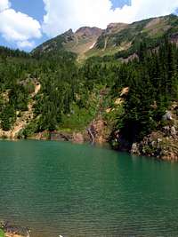
Above the ledges there is a faint boot path with occasional pieces of pink ribbon tied to branches and tree roots to mark the way. Rising steeply without switchbacks, the path stays on or near the top of the southwest ridge all the way to the summit. At 4200 feet the path runs along the south side of a massive eroded ravine. Beware of the possible collapse of rocks along the edge. At 5800 feet there is an overlook and possible bushwhack down to Ruby Lake which is a great destination for swimming in the heat of summer. Above the lake overlook, the boot path ends. Infrequent travel is not enough to scar the bushy slopes which are covered in wildflowers during the summer. There is one steep section that lasts for 300 vertical feet just after the path ends. It might be easier to ascend up through the vegetation just to the right of the ridge top rather than directly on top of it. At 6700 feet, after squeezing through some small trees marked with pink ribbon, there is no more ground cover vegetation and for the last several hundred feet the ridge consists of loose scree and rocks.
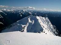
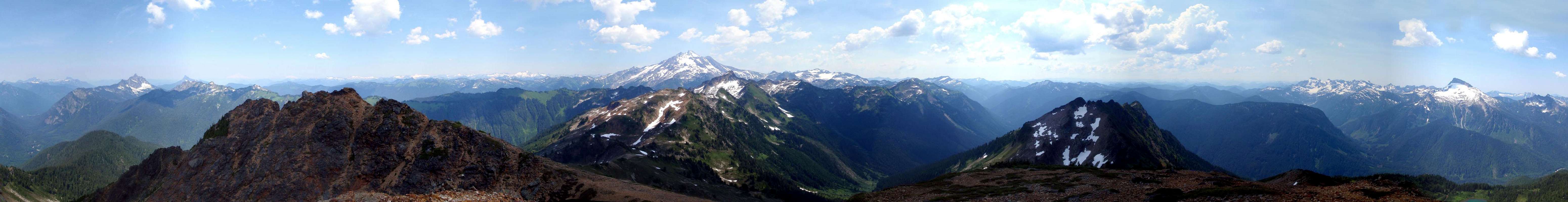
The Summit
Getting There
 | From Darrington drive south on the mountain loop highway 16 miles to the North Fork Sauk River Road number 308. This road may now be marked as Forest Road 49. It will be the second road on the left about a mile or two past the Mount Pugh trail head road. Turn left onto the road and drive 7.4 miles to the Sloan Creek Campground and North Fork Sauk trail head. As an alternative driving from the south end of the Mountain Loop Highway through Granite Falls is an option although I’m not sure about the mileage between Granite Falls and the turn off. This will add considerably to the amount of rough rode to be traveled. Watch for killer potholes either way. |  |
Red Tape
Remember to display your Northwest Forrest Pass when you park.External Links
Bryan's Trip Report of our 2009 experience2010 Trip Report of a winter ascent
Current Road Conditions
Darrington Ranger Station
1405 Emens Avenue North
Darrington, WA 98241
(360) 436-1155
Special thanks to Redwic for his help in gathering accurate information to build this page.