

-
 10013 Hits
-
 81.84% Score
-
 14 Votes
|
|
Route |
|---|---|
|
|
46.35605°N / 14.58650°E |
|
|
Download GPX » View Route on Map |
|
|
Hiking, Via Ferrata |
|
|
Summer, Fall |
|
|
Half a day |
|
|
Hike and Scramble |
|
|
Overview
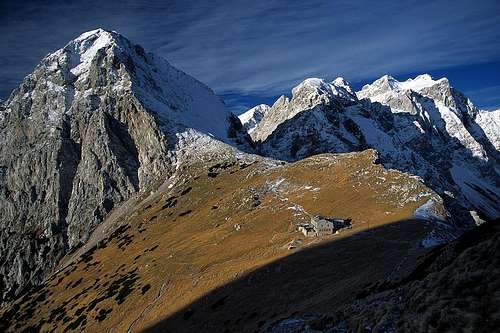 Kamniško sedlo with Brana Turska gora, Skuta and Rinke
The normal route to Brana usually is considered to be the rather demanding one hour hike and scramble from Kamniško sedlo to the summit. In the saddle you find Kamniska koca na Kamniskem sedlu, the closest mountain hut serving the area. On this page, however, I want to present the wholeascent from the north. It starts in Logarska Dolina at an elevation of 900 - 1000m and ends at the Brana summit 1200m higher. The ascent can be easily done in about 3 - 4h and thus makes Brana the easiest mountain to reach in the whole Kamnik Alps Range.
However, this des not mean the route is easy. While there are no reall difficulties, some sections between Frischaufov Dom and Kamniško sedlo are very exposed. Protection helps across the worst parts but still there are some slabs which have to negotiated without and can turn into traps in wet and slippery conditions. Rockfall is a constant danger in the upper traverse to the saddle, especially early in the year after the snow melted. The topmost part between Kamniško sedlo and Brana is less dangerous: a scree field traverse through the north face and a moderately exposed hike of the rather broad north-west ridge.
Early in the year, iin snow and ice, you need full mountaineering equipment. Snow remains on the north face deep into May / June and slipping will be fatal. There is a significant danger of avalanches on the traverse to Kamniško sedlo. Last but not least, in foggy conditions orientation on this traverse will become tricky. The path is marked but on the slab section there are several option some of which lead onto ledges above huge drops.
Getting There
  |
The route starts at the parking lot at the end of Logarska dolina. The Brana main page details how to get there.
Route Description
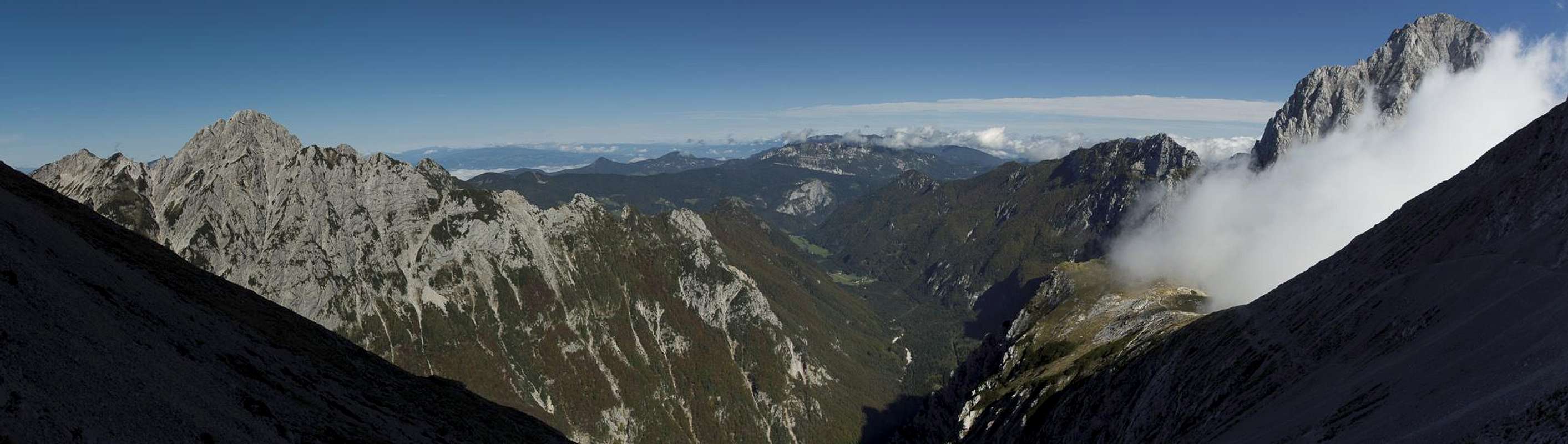
 Planjava above Kamniško sedlo, seen from the upper Brana north-west ridge
- General:
- Start altitude: 1000m
- Summit altitude: 2253m
- Prevailing exposure: N
- Type: Hike and Scramble
- Protection: Protected in the exposed sections
- Start altitude: 1000m
- Effort: 3 - Elevation gain: 1260m
- Power: 3 - Very Strenuous
- Psyche: 3 - Severe Exposure in some crux sections
- Difficulty: 3 - Steep hike and scramble
- Orientation: 2 - Marked and easy, a bit ambiguous on the slab traverse
From the parking lot follow the signposts which lead to Frischaufov dom, the mountain hut which is located at the mouth of the Okreslj Cirque. After a few minutes you reach the Rinka Waterfall (Slap Rinka), which is passed to the south. A zigzagging path leads across the step towards the top of the fall, where the Savinja Creek is crossed twice (protection). The path now leads southwards through a beech forest and after an hour reaches Frischaufov dom.
 Brana Brana |  Slap Rinka Slap Rinka |  Rinke Rinke |
Passing the hut the path still leads southwards towards a gully, which separates Turska gora from Brana. As it reaches the gully, the path turns shaprly left (marks have been lost here so pay attention), heading out onto a ledge. The lowest part of the ledge has broken away and there are at least two possible ways to reach it. Anyway, you have to breach a gap of about 2m here. The ledge quickly gets steeper and runs out onto a protected staircase cut into the rock, which steeply climbs through the lower Brana North Face. Above the stairs the path remains very steep and runs through the face in several protected switchbacks. Finally you reach a sort of sloped plateau.
 Staircase Staircase |  Staircase Staircase |  Ferrata Ferrata |
Here the rockfall (and avalanche) prone part of the hike starts. The path runs eastward across the plateau, heading for Kamniško sedlo. Several steep sections have to be negotiated, some across polished slabs, some with, some without protection. Finally you reach the elevation of Kamniško sedlo, to which you hike across a karst-like area.
 Planjava Planjava |  Logarska dolina Logarska dolina |  Signpost Signpost |
Even before you reach the saddle you get to the intersection with the Brana normal route. A signpost points westward across the upper Brana North Face. It leads to a scree field after the traverse of which another intersection is reached. The right hand path leads towards the difficult ferrata to Turska gora, the left hand path leads to Brana.
 |
Following the latter we soon turn left onto the upper north-west ridge with the help of some prootection (pegs and cables). There are impressve drops to both sides of the ridge, which, however, after a while turns wider and shallower. Finally, a short walk takes us towards the Brana summit.
 On the NW ridge On the NW ridge |  Last meters Last meters |  Gully View Gully View |