

-
 23751 Hits
-
 93.58% Score
-
 43 Votes
|
|
Mountain/Rock |
|---|---|
|
|
46.35419°N / 14.58834°E |
|
|
Hiking, Mountaineering, Trad Climbing, Ice Climbing, Mixed, Scrambling |
|
|
Spring, Summer, Fall, Winter |
|
|
7391 ft / 2253 m |
|
|
Overview
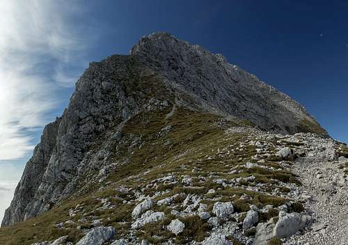 Brana seen from Kamniško Sedlo Brana seen from Kamniško Sedlo |
At 2253 m Brana is often considered to be only a secondary peak among the Kamnik Alps. embedded centrally in the range it pales in height against its more famous brethren Grintovec, Kočna or Skuta. However, it holds a centrall position on the ridge which separates Logarska Dolina from Kamniška Bistrica with tremendous drops on either side. In the south Brana drops with its immense face of Kaptan into Kamniška Bistrica valley. It is covered abundantly with vegetation and provides a difficult scrambling ascent to the mountain. Above Kaptan's top a broad and easy south ridge takes you to the summit.
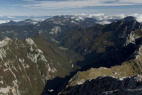
To the north you find Logarska Dolina valley, one of the highlights of the Kamnik Alps from which the mountain and its neighbours rises in several steep and giant steps. The easiest ascent, the normal route, negotiates these steps towards Kamniško sedlo, the saddle which separates Brana from its eastern neighbour, Planjava. From there one hour of hiking along a steep, exposed but protected trail takes you to the top of the mountain. It is considered one of the easiest and shortest ascents in the Kamnik Alps, which can be easily done on a long day from the valley floor. In unstable weather, in foggy, wet or snowy conditions the whole route can become a trap. In rainy conditions the lower slopes attract rockfall from the Brana North Face, while some of the polished slabs right beneath Kamniško sedlo can become downright slippery. In snow conditions the upper ridge traverse can only be done with proper equipment. Due to the many vertical sections a false step can prove lethal.
 |
 |
 |
To the west of Brana the Kotliči notch separates it from Turska gora and the western part of the Kamnik Alps. The traverse of both mountains is a popular means of accessing Brana. Even more deserving, froman alpinistic view, is the complete traverse of the west-east ridge from Kočna across Grintovec, Skuta, Turska Gora, Brana, Planjava and Ojstrica.
By borut:
Brana has three faces:
- The tall, steep and awesome west face drops from Blek, the summital basin, into the Kotliški Graben ravine.
- The east face, a confusion of pillars and gullies rises above the Pastirji meadow.
- Unfortunately statistically shadowed, the Brana north face quite expressly drops upon the Okrešelj meadow.
 |
 |
 |
- Alpinistic ascents are most popular on the east face (for instance the upper pillars, or the Bos gully).
- The west face offers very attractive, but difficult routes.
- The southern slopes (Kaptan) are mainly done along a summer scramble (tricky orientation), or the often avalanchous Bobnar gully in winter.
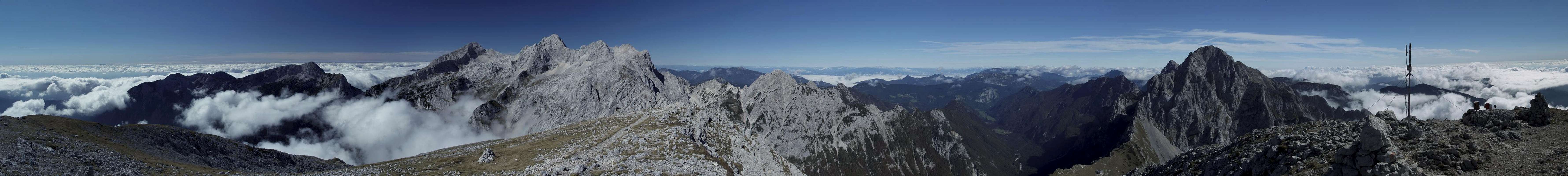
360° Summit Panorama
Getting There
 Logarska Dolina and Kamniško Sedlo
Logarska Dolina
- From Kamnik
- Take road 225 to Krivčevo.
- Switch to 924 north to Luče.
- Switch to 428 direction Paulitschsattel / Pavličevo sedlo.
- At Setstre Logar drive into Logarska dolina until its end.
- From Bad Eisenkappel (Austria)
- Take B82 to Bad Vellach
- After the resort turn left onto the narrow road to Paulitschsattel / Pavličevo sedlo
- Cross the Slovenian border onto 428 direction Luče
- At Setstre Logar drive into Logarska Dolina until its end.
Kamniška Bistrica
- From Kamnik
- Take 225 to Stahovica.
- Turn onto 923 into Kamniška Bistrica and drive to its very end
Red Tape
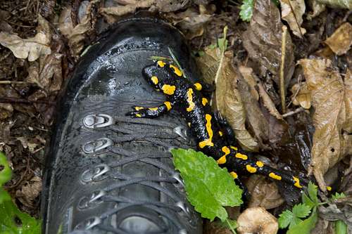 Fire Salamander stubbornly climbing my boot
- Unless signalized (barrier, signpost), and upon your own responsibility, you can use forest roads which are visible on maps (these roads are mainly maintained for lumbering and hut cable station access purposes).
- Fishing & hunting is regulated.
- Wild camping and open fires are not allowed.
- The Kamnik-Savinja Alps are part of the Natura 2000 program.
- The Logar valley (Logarska dolina) is a Landscape Parc and there is a reasonable fee for the road up the valley, in the summer months during the daytime.
Accommodation
The genral place to look for accommodation in Slovenia is www.slovenia.info. However, accommodation is a bit tricky to find there as accommodation is sorted by regions, three of which touch in the Kamnik Alps region (Central Slovenia, Savinjska and Gorenjska).
Camping
Weather Conditions
Maps & Books
Maps
- Grintovici
PZS: Planinska Zveza Slovenije
1:25000
Shop - Kamniško - Savinjske Alpe
PZS: Planinska Zveza Slovenije
1:50000
Shop - Klopeiner See / Karawanken Ost / Steiner Alpen
Kompass Map WK65
1:50000
ISBN: 978-3-85491-073-2
Books
- Vodnik Kamniško-Savinjske Alpe
V. Habjan, J. Drab, A. Poljanec, A. Stritar
PLANINSKI VODNIKI - Slovenija
ISBN: 978-9-61615-652-3 - Mountaineering in Slovenia
Tine Mihelič
Sidarta Guides
ISBN: 961-6027-36-0 - Karawanken und Steiner Alpen
Helmut Lang
Rother Verlag
ISBN: 978-3-7633-4424-6 - Klettersteige Julische Alpen, Steiner Alpen, Karawanken, Karnischer Hauptkamm
Hanns Heindl
Rother Verlag
ISBN: 3-7633-3372-x
External Links
Brana east face page (alpine climbs)