
-
 14484 Hits
-
 85.87% Score
-
 21 Votes
|
|
Route |
|---|---|
|
|
46.12575°N / 7.74583°E |
|
|
Mountaineering |
|
|
Summer, Fall |
|
|
Most of a day |
|
|
Moderate glacier hike |
|
|
Overview
 Brunegghorn high above Zermatt valley (14-08-2002)
If you drive up Zermatt valley you will get a glimpse of a very high and bold looking summit around the village of Sankt Niklaus. This is the summit of Brunegghorn, showing rockfaces and steep slopes of about 2000 meters of altitude difference.
But Brunegghorn “only” has a hight of 3.833 m and with its neighbours, Walliser Weißhornand “the easiest 4000 m summit” Bishorn, “little” Brunegghorn - being under the magic hight of 4000 m - is a rather forgotten mountain.
This has some advantages !
1. you will never find too many people on the top
2. it is an excellent and easy accessible mountain for acclimatisation and preparation for the “big Wallisians”
3. there are some interesting traverses, an interesting arete and a glacier involved
4. Brunegghorn is an EXCELLENT viewpoint for the Wallis mountains which includes a tremendous view of Weißhorn.
Four points to not forget this interesting mountain.
Brunegghorn has several "normal routes", two of which are described here.
Starting point for these two routes is the end of Turtmann valley, a southern side valley of the huge Rhone main valley.
 Brunegghorn as seen from Schöllihorn route (16-08-2004)
Getting There
 View from Holustei ascent to Turtmannhütte (11-08-2002)
Valley trailhead
The trailhead for the here described Brunegghorn routes is the lovely Turtmannhütte, high above Turtmanntal
For Turtmannhütte leave route number 9 in the Rhone valley at the village of Turtmann, located between Visp (east) and Sion / Sierre (west).
Follow the road up to Unterems and Oberems. The sometimes very narrow road continues to the south into Turtmann valley. The road ends some 3 km south of Gruben at “Sänntum”, there are parking areas and the trailhead for Turtmannhütte.
Ascents to Turtmannhütte
At the parking area follow the forest road up to the water reservoir at the end of Turtmann valley. You get there, too, by using a trail following closely the Turtmänna creek on its eastern side, crossing the creek and gaining the forest road at about half distance to the water reservoir.
The road follows the west rim of the reservoir, uses a natural dam to cross the valley and ends there. A trail starts to ascend the lower west slopes of Stellihorn, Barrhörner and Pipjitälli and zigzags up to the hut.
A nice variation is the above mentioned trail following the creek. Some 300 m from the parking area there is a trail junction. Use the left trail which ascends to the Holustei, a mountain farm hut, climbs up to a height of 2343 m and traverses the slopes of Amser Schafalpu. At Pipjitälli the Holustei trail joins the trail coming up from the water reservoir. Turtmannhütte is soon reached then.
Route Description
 Dramatic Weißhorn view from Brunegghorn ascent (16-08-2004)
Normal Summit Routes
Get started
I recommend to check the beginning of the trail on the evening before summiting, as you start your hike early in the morning, normally when it is still dark.
Follow the good trail from the hut to the south. You soon reach a shallow chute with some easy rocks, called “Gässi”. After Gässi follow the route which is marked with cairns on the ridge of a moraine. At your right there is Brunegg glacier, at your left there is a little valley. When the moraine ridge ends and you reach the little valleys bottom you have two possibilities to go on:
Glacier Route
Cross on moraine scree to the right until you easily reach Brunegg glacier. Ascend on the glacier keeping close on its east (orographic right) side until you are directly under Bruneggjoch. Ascend then directly to the south in the direction of Bisjoch between two crevasse zones. When you are above the upper crevasse zone turn back to the left and ascend the steeper west and nordwest slope of Brunegghorn where you join the
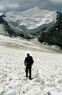 On the glacier route to Brunegghorn (16-08-2004)
Schöllihorn route
Follow the scree trail, marked with cairns, at the end of the moraine ridge. The trail steeply leads up to Schöllijoch between Üssers Barrhorn and Schöllihorn. Ascend the easy north ridge of Schöllihorn up to the summit (3499 m).
When the weather or the conditions are not good you can easily finish your ascend with a nice summit in the pocket.
For Brunegghorn descend the south ridge of Schöllihorn to Bruneggjoch. At Bruneggjoch traverse the steep west slope of Brunegghorn by entering the uppermost part of the glacier. You soon join the track of the glacier route. Ascend a col in the west ridge of Brunegghorn between the belays 3671 m in the west and 3699 m in the east. Follow the west / southwest ridge up to the yet visible summit with its breathtaking views.
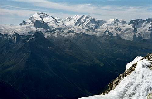 Summit view: Monte Rosa group (16-08-2004)
Traverses
Traverse 1
A great traverse which is now possible after the reopening of Topalihütte is the Brunegghorn traverse:
Turtmannhütte - glacier route - Schöllihorn route to Schöllijoch - via ferrata - Schölli glacier - Topalihütte (or vice versa).
Traverse 2
This traverse requires four to five days.
Jungu - Wasulicke - Topalihütte (first day)
Topalihütte - Schöllijoch - Schöllihorn - Brunegghorn - glacier route - Turtmannhütte (second day)
Turtmannhütte - traverse of lower Brunegg glacier to Turtmann glacier - Les Diablons - Cabane de Tracuit (third day)
Caband de Tracuit - Bishorn - Cabane de Tracuit - Zinal or
Bishorn - Bisjoch - Brunegg glacier - Turtmannhütte (fourth day)
Essential Gear & Mountain Conditions
 Brunegghorn summit ridge (16-08-2004)
Brunegghorn normal routes are normally done in summer and autumn. If it is a ski mountain in spring, too, I don´t know. Maybe some swiss SP folks can give some additions and comments to that topic.
Brunegghorn normal routes from Turtmannhütte require both basic glacier experience and full glacier gear with rope, ice axe and crampons.
Brunegghorn normal routes are a long days hike and a good hike to test your strength and get accustomed to the height before trying the "big summits" of Wallis.
Accomodations
 Turtmannhütte high above Brunegg and Turtmann glacier (15-08-2004)
Mountain Huts
Turtmannhütte
Topalihütte
Valley Accomodations
There are many possibilities to stay overnight in this region. The links to the closest villages are:
Turtmanntal
Sankt Niklaus
Randa
Maps & Guide Books
 Mischabel group with Dom and Nadelhorn as seen from Schöllihorn route (16-08-2004)
Maps
If you use the excellent Swiss topo maps 1 : 25.000 which are recommended for all high mountain activities, you unfortunately need three different maps to cover the area of Brunegghorn:
Map number 1328, Randa
Map number 1307, Vissoie
Map number 1308, Sankt Niklaus
Landeskarte der Schweiz, 1 : 25.000, Bundesamt für Landestopographie, 3084 Wabern
But map Randa for instance coveres the main parts of Mischabel group from Allalinhorn to Nadelgrat, too, so I think it is a good investment.
 Turtmannhütte (12-08-2002)
Guide Books
I only know the main guide books in german language:
Schweizer Clubführer
Walliser Alpen 5
Vom Strahlhorn zum Simplon
Schweizer Alpen Club, 1993
und
Walliser Alpen 3
Vom Col Collon zum Thedulpass
Schweizer Alpen Club, 2007
Michael Waeber
Walliser Alpen - Gebietsführer
Bergverlag Rudolf Rother, München