
|
|
Mountain/Rock |
|---|---|
|
|
49.48742°N / 123.19717°W |
|
|
5856 ft / 1785 m |
|
|
Overview
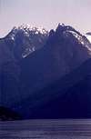
Brunswick Mountain is located within the confines of 3000Ha Cypress Provincial Park, located just above the suburb of West Vancouver. Brunswick is the highest peak in the group of peaks just to the north of Vancouver known as the North Shore Mountains. Brunswick like many of the peaks around Howe Sound was named after the ship captained by John Harvey, the HMS Brunswick. Brunswick's summit is steep and exposed, with precipitous drop offs on either side... marking this peak as more than simply an afternoon hiking destination. Even in July the snow near the top can be steeply corniced so take this peak seriously. Also there is plenty of loose, weathered rock so tread with caution when hiking along the summit ridge.
Prior to the 1980's access to Brunswick and its neighbouring peaks involved a lot of challenging and at times dangerous bushwacking until Halor Lunden created access to the peaks from Lion's Bay. With help from friends and volunteers he created the trail in the early eighties providing outodoors enthusiasts even further access to the beauty of the North Shore Mountains.
Cypress Provincial Park is located on the eastern shore of Howe Sound, a coastal fjord, it is a popular place for outdoor enthusiasts featuring downhill skiing, cross country skiing and plenty of hiking trails for the nearby mountains. The park was logged in the late 1870's by Moodyville lumberjacks for the tremendous stands of fir, hemlock and cedar that once grew there. Fortunately this practice was halted but not before most of all monarchs had been cut down.
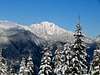
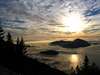
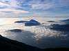
The view from the summit is breathtaking. Visible are steep rock faces, hauntingly isolated boulder filled valleys, remote jagged peaks, glaciers and many of the neighbouring islands including: Gambier, Keats and Bowen. It is a challenging 14.5km trail to the summit that takes from 7-10 hours depending on one's level of fitness.
 |  |  |  |  |
Getting There
Brunswick is located 40km north of downtown Vancouver. To get there head north on Highway 99 to Lions bay. Once you reach Lion's Bay turn right on Oceanview drive and then left on Cross Creek Rd. Continue on the road across harvey Creek until you reach Centre Rd. where you will take a right. From there take a left on Bayview followed by another left onto Mountain Dr. Again turn left on Sunset where you will come across the gate that marks the trailhead and bars further progress.
***Additional parking can be found at Lions Bay Elementary School 1km back along the road.
This is one of the most demanding hike in the Vancouver area so please don't underestimate it. You are asked to climb 1550m (5100ft) in around 7-10 hours so this is by no means a walk in the park.
Take the old logging road from the gate for 15 minutes or so until you reach a fork. From here follow to the right for an additional 45 minutes until you reach the next fork where you will take a left (the trail is marked with orange and pink markers). From there the road crosses magnesia Creek and the trail begins to steepen. At around 1000m the raod stops and turns into a winding trail. You will soon come to another fork, take the right trail, the trail steepens again here, but the view starts to open up. The trail follows several swithcbacks through the trees until you reach Brunswick's shoulder. You can look out over Howe Sound and see the Sechelt Peninsula as well as the coastal islands.
Head east on the trail, as previously mentioned the final 1.2km to the summit is steep and exposed (even in summer it is advisable to bring an ice axe). The trail stays just to the right of the crest, before moving to the left and avoiding a steep, dangerous scree slope. As you near the summit take the trail to the left for the best views and to reach the summit proper.
 |  |  |  |  |
Red Tape
There are no permits or user fees. The parking lot at the trailhead is small but no pass is needed, while the parking lot at Cypress Bowl has a lot more room but once again no pass is needed and there are no user fees. Recently fees have been added for parking which are set at $5 a day or $50 for a year long pass.
Conservation is of course encouraged, you are simply asked to leave the local animals and vegetaion alone and try to keep all impact to a minimum.
Numbers for Cypress Park
summer
1 604 926 6001
winter
1 604 928 0825
When To Climb
The best time of year to climb is from late May to mid October. In the winter it is possible, but snowfall in the North Shore Mountains is measured in the meters and any trip into the backcountry should only be made after talking to experienced members of the park staff.
The climb isn't much more difficult but getting there could be a real hazard as Vancouver can go for weeks at a time without seeing the sun and because of the egregious amounts of snow (as previously mentioned
 |  |  |  |  |
Camping
As far as camping goes there are designated campsites along the Howe Sound Crest Trail, a 29km trail that starts at Cypress Provincial Park and provides access to 9 summits in the north Shore Mountains. Other than that camping is restricted, Brunswick is a day hiking destination so camping is frowned upon by park staff unless there is an emergency.
Numbers for Cypress Park
summer
1 604 926 6001
winter
1 604 928 0825
Mountain Conditions
The best way to check the weather is to check the weather at the Cypress Bowl ski resort, or failing that check the weather (the weathernetwork.com) for the city of Vancouver or its suburbs of North and West Vancouver.
Check www.compusmart.ab.ca. I found this on a page entitled extensive moutnain weather forecasts. I checked it out and it has forecasts for all of the parks. Straightforward to navigate as well.
ClimberMan420 - Feb 18, 2009 1:47 am - Hasn't voted
Winter + campingThere are no designated camping spots on the Howe Sound Crest trail. The best campspots though, are along the trail 1 km (as the crow flies)to the south in Magnesia Meadows where there is a new emergency shelter and always some form of water or 1 km (as the crow flies) to the north on Brunswick Lake where there e is also a new (2009) emergency shelter. The Cypress Bowl Ski area would not be used unless hiking the entire Howe Sound Crest trail which is a very long 30km often done in 3-4 days. In winter there is usually one steep 20m slope on the trail as trees begin to thin out towards subalpine about 150m after crossing the Howe Sound Crest trail(well signed)that usually requires ice axe and crampons and can be exposed. Snow shoes are usually prefered as trail is not great for skis. Summit ridge is exposed requiring careful ice axe protectioning and parties often do not continue past 1 peak (50m lower than highest peak) Great page!