
-
 3329 Hits
-
 73.06% Score
-
 3 Votes
|
|
Route |
|---|---|
|
|
46.70220°N / 12.19482°E |
|
|
Hiking, Skiing |
|
|
Spring, Summer, Fall, Winter |
|
|
Half a day |
|
|
Hike |
|
|
Overview
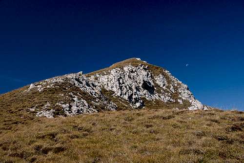 The Sarlkofel western summit The Sarlkofel western summit |
Sarlkofel is a substitute summit when neighbouring Dürrenstein / Picco di Vallandro is not an option, for instance when the higher summit is in clouds. In that case Sarlkofel and neighbouring Lungkofel often are climbed by either one of two routes, starting from Bad Altprags / Bagni di Braies. The more popular route is the northern one, which leads through the Buchsenriedel Saddle to Sarlsattel, which separates the two mountains. From there a narrow path leads along protected ledges towards the Sarlkofel summit.
Though there are two or three short protected sections, the ascent to Sarlkofel is an easy hike. In its first two sections (up to Sarlsattel) the hike runs through dense forests and only occasionaly views open up to the north. This abruptly changes when getting close to the saddle when the path nrrows and exposure gets more than average. The final part is a very scenic panorama hike with the Sexten / Sesto- and Prags / Braies- Dolomites as a backdrop.
Getting There
The starting point is Bad Altprags / Bagni di Braies to the south of Pustertal Valley / Val Pusteria. You can reach it by a short southward dash from Toblach / Dobiaco.Route Description
- Start altitude: 1379m
- Summit altitude: 2380m
- Prevailing exposure: North, later south
- Type: Steep hike, exposed in the upper section
- Protection: Several short (5m) cables in the upper section
The hike starts at the end of the road in Bad Altprags / Bagni di Braies, directly beside the small ski lift. There a dirt road (marked no. 15) leads in the direction of Niederdorf / Villabassa (signs), crosssing the ski slope meadows. It soon enters the forest, where it starts ascending steeply along the south slopes of Allwartstein / Sasso di Pozzo (also a possible summit destination, 1954m). After a while the trail leaves the road and very steeply climbs towards the Buchsenriedel Saddle (1803m).
 Putzalm Putzalm |  Roßkopf Group Roßkopf Group |
On the eastern side of the saddle (signs) trail no 16 leads downward towards the Putzalm Pasture (1743m). Turn sharply right after the Alm, following the signs to Sarlkofel and Suesskopf. Soon the two trails split with the right branch running southward directly towards the north face of Sarlkofel. At abouut 2000m you reach the timberline from where a steep scree path leads you to the second saddle, Sarlsattel.
 On the Sarlkofel south slopes
Sarlkofel / Monte Serla
In the saddle turn left (following the signs to Sarlkofel. The trail soon leaves the saddle and heads through the south-west face of the westernmost summit of the mountain. Here a few cable protections guide you to the Sarlkofel south slopes (more protection). The trail heads for a saddle between the western and central summit, then passes the latter to the south to finally head up to it from the south-east.
Lungkofel / Monte Lungo
In the saddle, turn right and follow the ridge for a while. The path heads down into a dell, where the Lungkofel ascent route turns off to the left. The path is not marked but obvious and takes you steeply up to the summit.